Providencia and Santa Catalina Islands facts for kids
Quick facts for kids
Providence and Saint Catherine
(Jamaican Patois: Pravidenz an Sient Khachrin)
|
|||
|---|---|---|---|
| Providence and Saint Catherine Islands | |||
|
|||

Urban settlements in Providencia Island
|
|||
| Country | |||
| Department | San Andres and Providencia | ||
| Region | Caribbean | ||
| Established | 1853 | ||
| Capital | Saint Elizabeth (Providence) | ||
| Area | |||
| • Total | 18 km2 (7 sq mi) | ||
| Elevation | 2 m (7 ft) | ||
| Population
(2006)
|
|||
| • Total | 4,900 (approx.) (Census DANE 2,005) | ||
| Demonym(s) | Providenciano (a)(s) | ||
| Time zone | UTC-5 (EST) | ||
| Area code(s) | 57 + 8 | ||
Providence and Saint Catherine (also known as Pravidenz an Sient Khachrin in the local language) is a special group of islands in Colombia. It's part of the Raizal Islands department. These islands are found off the northern coast of Providencia Island. The area also includes several small, uninhabited islands (called cayes) to the north and east.
Around 5,000 people live here. About 15,000 tourists visit each year. The islands are famous for scuba diving. There's a huge 32-kilometer-long barrier reef. This reef protects the eastern coast of the main island.
Contents
Geography of Providence Island
This section describes the main island of the Providence group. It is the second largest island in its department.
Location and Size
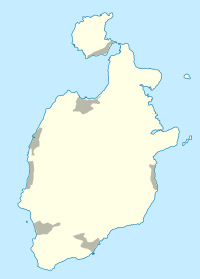
Providencia Island is located at 13°21′N 81°22′W. It stretches about 7.2 kilometers from north to south. The land area of Providencia Island is 17 square kilometers.
Island Features
The center of Providencia Island is mountainous. It has three peaks that are all about 363 meters high. The island is made of sedimentary rocks. These rocks formed on top of an old volcano.
The main town is Saint Elizabeth. It is in the north, close to Santa Catalina Island. Other villages include Lazy Hill on the west coast and Bottom House in the southeast.
Low Cay
Low Cay is a very small islet. It is located more than 10 kilometers further north. Its coordinates are 13°32′N 81°21′W.
History of the Islands
The history of Providence and Saint Catherine involves early settlers and local people.
First Contact and English Influence
The Miskito people from the mainland first met the English in 1639. This was when the Second Earl of Warwick started his Providence Island colony. The Earl convinced the Miskito leader to send his son to England. This son, known as Oldman, met King Charles I. The King gave him a special title. Oldman later returned home to become king.
His son, Jeremy, visited Jamaica in 1688. He asked for English protection because of problems with the Spanish. After this, all future Miskito kings were approved by the Governor of Jamaica.
Settlers and Treaties
Over time, English and American settlers came to the islands. Some were escaped prisoners or slaves. Many married local people. Their children became involved in the Miskito kingdom.
The Miskito people and the Spanish often had conflicts. More settlers made these tensions worse. British businesses were also interested in logging wood in nearby Honduras. This increased Spanish concerns.
So, Britain became more involved in the region. In 1740, Miskito king Edward I and the British signed a Treaty of Friendship and Alliance. In 1749, a British Superintendent was appointed. This person helped the Miskito king. They also helped create a legal system and a system for land ownership.
People of the Islands
The people living on Providence and Saint Catherine have a unique culture.
The Raizal Community
The local population is called the Raizals. They are an Afro-Caribbean group. Most Raizal people are Protestant. They speak San Andrés–Providencia Creole, which is an English-based language. Many also speak Spanish.
More Spanish-speaking people from Colombia have moved to the islands. This has increased the use of Spanish. However, the Raizal people are still the main group. This is different from the nearby island of San Andrés, where Spanish is much more common.
Historical Connections
An old forum about the islands mentions their history. It says that the heritage goes back to before colonial times. It talks about Dutch sea captains who lived on San Andres and Old Providence. One of them, Abraham Blauvelt, founded a place called Bluefields, naming it after himself.
Getting Around the Islands
There are several ways to travel to and from Providence and Saint Catherine.
Air Travel
The local El Embrujo Airport has daily flights. These flights come from Gustavo Rojas Pinilla International Airport in San Andrés. Satena operates regular flights. Decameron/Searca offers charter flights.
Sea Travel
A catamaran boat can carry 50 people. It travels between San Andres and Providencia Island. The trip takes about two and a half hours each way. The catamaran makes this trip four times a week. It leaves San Andres in the morning and returns in the afternoon.
Wildlife and Nature
The islands are home to unique animals.
Land Animals
Because the islands are isolated, there are not many types of land animals. Many of the animals found here are unique to the islands.
- Only one type of frog has been found: Leptodactylus insularis.
- Only one type of land turtle has been found: Geochelone carbonaria.
- Two types of snakes have been reported: Boa constrictor imperator and Leptotyphlops magnamaculata.
- Six types of lizards have been seen.
- Ten types of birds live on the islands.
- Four types of sea turtles visit the waters around the islands.
- A few types of mammals also live here.
Climate
The weather on Providencia Island is generally warm.
| Month | Jan | Feb | Mar | Apr | May | Jun | Jul | Aug | Sep | Oct | Nov | Dec | Year |
|---|---|---|---|---|---|---|---|---|---|---|---|---|---|
| Record high °C (°F) | 30.8 (87.4) |
32.4 (90.3) |
33.2 (91.8) |
35.1 (95.2) |
32.9 (91.2) |
32.6 (90.7) |
31.9 (89.4) |
32.8 (91.0) |
33.0 (91.4) |
32.4 (90.3) |
32.0 (89.6) |
31.6 (88.9) |
35.1 (95.2) |
| Mean daily maximum °C (°F) | 29.6 (85.3) |
30.0 (86.0) |
30.7 (87.3) |
31.3 (88.3) |
31.7 (89.1) |
31.6 (88.9) |
31.2 (88.2) |
31.6 (88.9) |
31.9 (89.4) |
31.4 (88.5) |
31.0 (87.8) |
30.3 (86.5) |
31.0 (87.8) |
| Daily mean °C (°F) | 26.6 (79.9) |
26.5 (79.7) |
26.8 (80.2) |
27.4 (81.3) |
28.0 (82.4) |
28.1 (82.6) |
28.1 (82.6) |
28.1 (82.6) |
27.9 (82.2) |
27.5 (81.5) |
27.4 (81.3) |
26.9 (80.4) |
27.4 (81.4) |
| Mean daily minimum °C (°F) | 21.9 (71.4) |
21.8 (71.2) |
21.3 (70.3) |
23.3 (73.9) |
24.0 (75.2) |
23.6 (74.5) |
23.8 (74.8) |
23.6 (74.5) |
23.1 (73.6) |
23.1 (73.6) |
22.5 (72.5) |
22.6 (72.7) |
22.9 (73.2) |
| Record low °C (°F) | 18.9 (66.0) |
18.9 (66.0) |
19.2 (66.6) |
21.4 (70.5) |
22.0 (71.6) |
21.0 (69.8) |
19.8 (67.6) |
22.2 (72.0) |
21.8 (71.2) |
22.0 (71.6) |
20.5 (68.9) |
21.2 (70.2) |
18.9 (66.0) |
| Average rainfall mm (inches) | 74.4 (2.93) |
45.8 (1.80) |
23.8 (0.94) |
35.0 (1.38) |
116.1 (4.57) |
173.4 (6.83) |
143.9 (5.67) |
154.0 (6.06) |
182.2 (7.17) |
301.9 (11.89) |
256.9 (10.11) |
130.1 (5.12) |
1,637.5 (64.47) |
| Mean monthly sunshine hours | 229.9 | 225.8 | 260.3 | 255.6 | 226.6 | 186.7 | 209.7 | 232.5 | 195.2 | 188.5 | 180.5 | 194.7 | 2,586 |
| Source: Instituto de Hidrologia Meteorologia y Estudios Ambientales | |||||||||||||
See also
 In Spanish: Providencia y Santa Catalina Islas para niños
 | Isaac Myers |
 | D. Hamilton Jackson |
 | A. Philip Randolph |


