Puerto Cabezas facts for kids
Quick facts for kids
Puerto Cabezas
|
|||
|---|---|---|---|
|
Municipality
|
|||

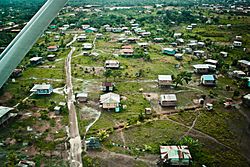
Aerial view of city
|
|||
|
|||
| Country | |||
| Department | |||
| Area | |||
| • Municipality | 2,311 sq mi (5,985 km2) | ||
| Population
(2022 estimate)
|
|||
| • Municipality | 134,535 | ||
| • Density | 58.220/sq mi (22.4787/km2) | ||
| • Urban | 84,189 | ||
| Time zone | UTC-6 (Central Time) | ||
| • Summer (DST) | UTC-6 (No DST) | ||
| Climate | Am | ||
Puerto Cabezas, also known as Bilwi, is an important city and a municipality in Nicaragua. It's the main city of the Miskito nation and the capital of the North Caribbean Coast Autonomous Region. This whole area is considered traditional land for Native American communities. The city of Puerto Cabezas is located next to the Community of Ten Communities.
Contents
History of Puerto Cabezas
Puerto Cabezas has faced some powerful storms. On September 4, 2007, Hurricane Felix hit the city. Later, in 2020, two more strong hurricanes caused a lot of damage. Hurricane Eta arrived on November 3, 2020, and just a few days later, on November 16, 2020, Hurricane Iota hit as a very strong Category 4 storm. These hurricanes brought heavy winds and rain, affecting many homes and buildings.
Climate and Weather
Puerto Cabezas has a tropical monsoon climate. This means it gets a lot of rain throughout the year. There is a short dry season in March and April, but even then, it still rains quite a bit.
Rainfall and Temperatures
The average temperature in Puerto Cabezas usually stays warm. It ranges from about 24.5°C (76°F) in February to 27.8°C (82°F) in May. The city receives a lot of rain each year, with an average of 2799 millimeters (110 inches). On average, it rains on 198 days out of the year.
| Climate data for Puerto Cabezas | |||||||||||||
|---|---|---|---|---|---|---|---|---|---|---|---|---|---|
| Month | Jan | Feb | Mar | Apr | May | Jun | Jul | Aug | Sep | Oct | Nov | Dec | Year |
| Mean daily maximum °C (°F) | 29.7 (85.5) |
29.7 (85.5) |
30.5 (86.9) |
31.3 (88.3) |
31.8 (89.2) |
31.4 (88.5) |
30.8 (87.4) |
31.2 (88.2) |
31.2 (88.2) |
31.6 (88.9) |
30.8 (87.4) |
29.7 (85.5) |
30.8 (87.5) |
| Daily mean °C (°F) | 25.0 (77.0) |
24.5 (76.1) |
26.5 (79.7) |
27.2 (81.0) |
27.8 (82.0) |
27.5 (81.5) |
27.1 (80.8) |
27.1 (80.8) |
27.0 (80.6) |
26.3 (79.3) |
25.8 (78.4) |
25.4 (77.7) |
26.4 (79.6) |
| Mean daily minimum °C (°F) | 18.8 (65.8) |
18.6 (65.5) |
19.8 (67.6) |
20.9 (69.6) |
21.8 (71.2) |
22.0 (71.6) |
21.9 (71.4) |
22.0 (71.6) |
22.2 (72.0) |
21.6 (70.9) |
20.8 (69.4) |
19.3 (66.7) |
20.8 (69.4) |
| Average rainfall mm (inches) | 148 (5.8) |
83 (3.3) |
48 (1.9) |
54 (2.1) |
183 (7.2) |
378 (14.9) |
414 (16.3) |
370 (14.6) |
303 (11.9) |
338 (13.3) |
278 (10.9) |
202 (8.0) |
2,799 (110.2) |
| Average rainy days (≥ 1.0 mm) | 16 | 11 | 7 | 8 | 12 | 20 | 23 | 22 | 20 | 20 | 19 | 20 | 198 |
| Source: Hong Kong Observatory | |||||||||||||
Culture and Traditions
The culture in Puerto Cabezas is very rich and diverse. The main culture is that of the Miskito people. Other important cultures include Creole, Mayangna, and Latino traditions. Just like the rest of Nicaragua's Caribbean coast, the city's culture has a strong Caribbean feel.
Education Opportunities
Puerto Cabezas is home to a campus of the University of the Autonomous Regions of the Nicaraguan Caribbean Coast (URACCAN). This university helps provide higher education to students in the region. There are other URACCAN campuses in different parts of the RACCN and RACCS.
Getting Around: Transportation
The city has its own airport, called Puerto Cabezas Airport. This airport helps people travel to and from the city.
Sister Cities Around the World
Puerto Cabezas has special connections with other cities around the world. These are called "sister cities" and they work together to share culture and ideas. Puerto Cabezas is a sister city to:
 Burlington, United States
 Luleå, Sweden
 Sant Pere de Ribes, Spain
 Vilafranca del Penedès, Spain
See also
 In Spanish: Puerto Cabezas para niños
 | William M. Jackson |
 | Juan E. Gilbert |
 | Neil deGrasse Tyson |


