Puquios facts for kids
| Alternative name | Filtration Galleries |
|---|---|
| Location | Nazca, Ica Region, Peru |
| Coordinates | 14°49′34″S 74°54′40″W / 14.826°S 74.911°W |
| Type | irrigation system |
| History | |
| Founded | c. 500 CE |
| Abandoned | Still in use |

Puquios (say "POO-kee-ohs") are amazing ancient water systems. The word comes from the Quechua word pukyu, meaning "source" or "spring."
These systems are like underground tunnels or channels. They help move water over long distances in hot, dry places. This way, not much water is lost to evaporation.
You can find puquios in the desert areas of southern Peru and northern Chile. In the early 21st century, 43 puquios in the Nazca region were still working. They bring fresh water for farming and for people to use in their homes.
Some experts think the Nazca people started building these puquios around 500 CE. The way they work is similar to Qanats, which are ancient water systems found in Iran and other desert areas.
How Nazca Puquios Work
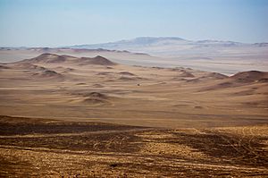
The coasts of Peru and Chile are very dry. Farming is only possible if you can bring water in. The Nazca region gets very little rain. Rivers like the Rio Grande de Nazca only have water during certain times of the year.
The ancient Nazca culture lived here from 200 BCE to 650 CE. They might have built the puquios to get water when the climate became drier. This allowed them to grow crops and live in this desert area.
The Nazca puquios are found along several rivers that flow into the Rio Grande de Nazca. These rivers start in the Andes mountains. Even though the rivers are often dry, they have water underground. The puquios were built to tap into this underground water.
As of the year 2000, 43 puquios were still in use. Many of these are near the city of Nazca. The Cantalloc Aqueducts are some of the most famous puquios.
There are two main types of puquios in the Nazca region:
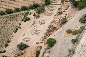
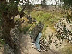
- Trench puquios: These are deep, narrow ditches open to the sky. They are usually lined with rocks.
- Gallery puquios: These are tunnels dug underground. They reach water from an aquifer (an underground layer of water). The water then flows through the tunnel, coming out into a trench puquios.
The underground tunnels are usually about one meter (about 3 feet) wide and tall. Along the path of the underground tunnel, there are vertical shafts. These are called "eyes" or "ojos" (Spanish for "eyes"). These "ojos" are like funnels that go from the surface down to the tunnel. They let people get into the tunnel for cleaning and repairs. The "ojos" are usually spaced about 10 to 30 meters (30 to 100 feet) apart.
The underground part of a puquios can be from a few meters to over 370 meters (about 1,200 feet) long. The open trench part can be even longer, up to a kilometer (about half a mile).
History of the Puquios
Along Peru's long desert coast, there are many river valleys. Ancient people in these valleys used irrigation to farm. The Nazca people were very good at farming in their dry region because of the puquios. This technology allowed many people to live in a very dry place.
The Spanish arrived in the Nazca region in the late 1500s. They continued to use the puquios for farming, especially for growing grapes and making pisco (a type of brandy). In 1853, an English traveler named Clements Markham visited the Nazca valley. He said it was "the most fertile and beautiful spot on the coast of Peru." He noted that this amazing fertility was thanks to the "skill and industry of the ancient inhabitants."
Today, many puquios are still used. However, their use is becoming less common. Modern farming methods, like growing crops for export, often use deep wells instead. These deep wells pump out a lot of underground water. Also, fewer local people know how to maintain the old puquios.
The water in the puquios is naturally refilled each year by rain in the Andes mountains. But using too much underground water from deep wells might not be good for the future.
See also
 In Spanish: Puquio (manantial) para niños
 | Emma Amos |
 | Edward Mitchell Bannister |
 | Larry D. Alexander |
 | Ernie Barnes |


