
Ica Region facts for kids
Quick facts for kids
Ica Region
|
||
|---|---|---|

Nazca Lines: "Dog"
|
||
|
||
.svg)
Location of the Ica Region in Peru
|
||
| Country | Peru | |
| Subdivisions | 5 provinces and 43 districts | |
| Capital | Ica | |
| Area | ||
| • Total | 21,327.83 km2 (8,234.72 sq mi) | |
| Elevation
(Capital)
|
406 m (1,332 ft) | |
| Highest elevation | 3,796 m (12,454 ft) | |
| Lowest elevation | 0 m (0 ft) | |
| Population
(2004 estimate)
|
||
| • Total | 709,556 | |
| • Density | 33.269020/km2 (86.16637/sq mi) | |
| Dialing code | 056 | |
| ISO 3166 code | PE-ICA | |
| Principal resources | Iron, cotton, grapevine, kidney beans. | |
| Poverty rate | 41.7% | |
| Percentage of Peru's GDP | 2.36% | |
| Website | www.regionica.gob.pe | |

Ica is a special area, or region, in Peru. It's like a big state or province. It's located on the western side of Peru, right next to the Pacific Ocean. To its north is the Lima Region, and to its east are the Huancavelica and Ayacucho regions. To the south, you'll find the Arequipa Region. The main city and capital of Ica is called Ica.
Contents
Fun Things to Do in Ica
Ica is a really interesting place to visit! It's famous for its sunny and dry weather, which means lots of clear days to explore. This region is well-known for making delicious wine and a special Peruvian drink called pisco.
Festivals and History
Every year, Ica hosts exciting festivals, or fiestas, where you can experience local traditions and music. You can also visit a museum to learn about the area's past. There are also many old colonial churches that show off beautiful historic architecture.
Amazing Places to See
Ica is home to some incredible natural wonders and ancient mysteries.
The Mysterious Nazca Lines
One of the most famous attractions near Ica is the Nazca Lines. These are huge designs carved into the desert floor by ancient people. They show animals like spiders and dogs, and also geometric shapes. No one is completely sure why they were made, but they are amazing to see from above!
Wildlife at Ballestas Islands
Just off the coast of Ica, you can visit the Ballestas Islands. These islands are sometimes called the "mini-Galapagos" because they are full of amazing wildlife. You can see many sea lions resting on the rocks and different kinds of birds flying around. It's a great place for nature lovers!
Beautiful San Nicolás Bay
The Bay of San Nicolás in Marcona is another beautiful coastal spot in the Ica region. It's a lovely bay with a harbor where you can see boats and enjoy the ocean views.
Images for kids
-

Nazca Lines: figure of the Spider.
-
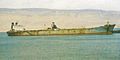
Bay and harbor of San Nicolás in Marcona.
-
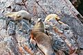
Sea Lions on the Ballestas Islands.
-
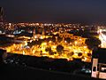
Plaza de Armas in Ica, the oldest part of the capital of the department.


See also
 In Spanish: Departamento de Ica para niños
