
Ica, Peru facts for kids
Quick facts for kids
Ica
|
|||
|---|---|---|---|
   .jpg)   Huacachina Oasis, Lord of Luren Temple, San Francisco Church, El Catador Winery, Plaza de Armas at night and Huacachina Dunes.
|
|||
|
|||

Ica, Peru
Location in Peru
|
|||
| Country | |||
| Region | Ica | ||
| Province | Ica | ||
| Founded | 17 June 1563 | ||
| Founded by | Jerónimo Luis de Cabrera | ||
| Government | |||
| • Type | Democracy | ||
| Area | |||
| • Total | 7,894 km2 (3,048 sq mi) | ||
| Elevation | 406 m (1,332 ft) | ||
| Population
(2017)
|
|||
| • Total | 282,407 | ||
| • Estimate
(2015)
|
244,390 | ||
| • Density | 35.7749/km2 (92.657/sq mi) | ||
| Demonym(s) | Iqueño/a | ||
| Time zone | UTC-5 (PET) | ||
| • Summer (DST) | UTC-5 (PET) | ||
| Area code(s) | 56 | ||
| Website | www.muniica.gob.pe | ||


Ica (pronounced EE-kah) is a city in southern Peru. It is the capital of the Department of Ica. The area has been home to different indigenous peoples for a very long time. A Spanish explorer named Jerónimo Luis de Cabrera officially founded the city in 1563.
In 2017, Ica had a population of over 282,407 people. The city faced a lot of damage and sadness during a big earthquake in 2007.
Contents
History of Ica
Ancient Times and Cultures
Scientists found the fossil remains of a very old penguin in 2007. This penguin, called Icadyptes salasi, lived in the Atacama Desert about 30 million years ago. It was about 137 to 152 centimeters (4.5 to 5 feet) tall. It also had a long beak, about 30 centimeters (1 foot) long.
Evidence of ancient civilizations has been found in the nearby deserts. These include the Paracas culture, known for their amazing textiles. Other groups like the Chincha people and the Inca also lived here. The Inca ruled this area starting in the 1300s. You can see many old artifacts from these cultures at the Museo Regional de Ica.
Spanish Founding and Independence
The Inca were still in charge when Spanish explorers arrived. The Spanish colonial city was founded on June 17, 1563. It was first called Villa de Valverde. Spain ruled Ica until Peru became an independent country in 1821.
The 2007 Earthquake
On August 15, 2007, a very strong earthquake happened off the coast of Peru. It was a magnitude 8.0 earthquake. This earthquake caused a lot of damage to buildings and homes in Ica. Many people were hurt, and some buildings, like a church, sadly collapsed. The nearby city of Pisco was also badly affected. About 80% of Ica's buildings were destroyed.
Geography of Ica
Ica is located along the desert coast of southern Peru. It sits on the Ica River, about 300 kilometers (186 miles) south of Lima. Further south, you can find the city of Nazca along the Pan-American Highway.
Climate and Weather
Ica is on the edge of the Atacama Desert. This means it has one of the driest climates in the world. It gets only about 1 centimeter (0.4 inches) of rain in a whole year! Summers (December to March) are hot. Winters (June to September) are warm.
| Climate data for Ica (San Camilo), elevation 407 m (1,335 ft), (1991–2020) | |||||||||||||
|---|---|---|---|---|---|---|---|---|---|---|---|---|---|
| Month | Jan | Feb | Mar | Apr | May | Jun | Jul | Aug | Sep | Oct | Nov | Dec | Year |
| Mean daily maximum °C (°F) | 31.9 (89.4) |
33.0 (91.4) |
33.4 (92.1) |
31.9 (89.4) |
29.2 (84.6) |
26.0 (78.8) |
25.2 (77.4) |
26.1 (79.0) |
27.8 (82.0) |
29.2 (84.6) |
30.0 (86.0) |
31.0 (87.8) |
29.6 (85.2) |
| Mean daily minimum °C (°F) | 17.8 (64.0) |
18.7 (65.7) |
17.8 (64.0) |
15.5 (59.9) |
12.4 (54.3) |
10.8 (51.4) |
10.3 (50.5) |
10.4 (50.7) |
10.9 (51.6) |
12.1 (53.8) |
13.4 (56.1) |
15.6 (60.1) |
13.8 (56.8) |
| Average precipitation mm (inches) | 5.0 (0.20) |
2.2 (0.09) |
1.2 (0.05) |
0.2 (0.01) |
0.1 (0.00) |
0.4 (0.02) |
0.3 (0.01) |
0.2 (0.01) |
0.1 (0.00) |
0.0 (0.0) |
0.2 (0.01) |
0.2 (0.01) |
10.1 (0.41) |
| Source: National Meteorology and Hydrology Service of Peru | |||||||||||||
Transportation in Ica
You can reach Ica from Lima by driving on the Pan-American Highway. This trip is about 320 kilometers (199 miles) long. There are also plans to build a new train line called the Tren de la Costa.
Tourism and Fun in Ica
Ica and the areas around it are famous for making Pisco brandy. The Museo Regional de Ica is a regional museum that shows many interesting things. You can see artifacts from ancient times all the way to the Spanish colonial period.
Museum Highlights
The museum displays include ancient burial bundles and mummies. Some skulls from the Paracas culture and other pre-Inca groups are very long. This suggests people changed the shape of their heads on purpose, maybe to show they were important. Some skulls also show signs of trepanning. This was an early type of brain surgery done to help with pressure or injuries. The museum also has old furniture, paintings, and items from when Spain ruled the area.
Desert Adventures
The Ica region has a lot of desert, which makes it a special place for tourists. The Huacachina oasis is a beautiful lake surrounded by huge sand dunes. Many people from Peru and other countries visit Ica. Young visitors often enjoy sandboarding down the dunes. Others like to explore the dunes in special vehicles called sand buggies.
Agriculture and Water
Ica gets many sunny days, making it a great place for farming. Important crops grown here include cotton, grapes, asparagus, avocado, mango, and olives. Peruvians call Ica the "Land of Eternal Sun."
Even though the area has four seasons, the weather is always warm and dry. Visitors often say it feels like summer all year long. The dry climate can also be helpful for people with asthma.
Ica gets its water for homes and farms from an underground water source called an aquifer. This aquifer is filled by melting ice from glaciers. However, people are using more water than the aquifer can refill. Because of this, the aquifer is drying up quickly. People are suggesting ways to use water more wisely, like better irrigation, or building dams to collect more water.
Images for kids
-
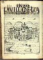
Ica in 1615, by Guamán Poma
-
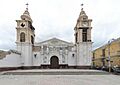
Ica Cathedral with damage from earthquake of 2007


See also
 In Spanish: Ica para niños
