
Putauaki facts for kids
Quick facts for kids Putauaki |
|
|---|---|
| Mount Edgecumbe | |

Putauaki (Mount Edgecumbe) from the north
|
|
| Highest point | |
| Elevation | 821 m (2,694 ft) |
| Geography | |

Putauaki
Location in North Island
|
|
| Geology | |
| Last eruption | 540 ± 130 BCE |
Putauaki (Māori: Pūtauaki), also known as Mount Edgecumbe, is a special mountain in the Bay of Plenty Region of New Zealand. It's a volcanic cone, which means it's shaped like a cone and was formed by a volcano.
This mountain stands tall at 821 meters (about 2,694 feet) above the sea. You can see it clearly from the Bay of Plenty, which is about 30 kilometers (18 miles) away. Putauaki is located near Kawerau, about 50 kilometers (31 miles) east of Rotorua. It's part of the Taupo Volcanic Zone.
For many years, a "King of the Mountain" race was held on Putauaki. This race was part of a bigger international series. Money raised from the race was given to charities.
Contents
The Mountain's History
The last big volcanic eruption at Putauaki happened around 2490 BCE (Before Common Era). This eruption produced a huge amount of lava, about one cubic kilometer. Before that, another eruption took place around 3330 BCE.
These eruptions created the "Edgecumbe Formation." This formation includes lava flows, domes, and small pieces of rock called tephra.
How Putauaki Got Its Name
In 1769, Captain James Cook named the mountain "Mount Edgecumbe." He might have named it after John Edgecombe, who was a marine on his ship, the Endeavour.
However, in 1925, the mountain's official name was changed back to Putauaki. This is its original Māori name.
Land and the Ngāti Awa People
In the 1880s, the New Zealand government took some land on the mountain from the Ngāti Awa people. This was part of a series of land confiscations in the North Island.
Later, in 1999, a group called the Waitangi Tribunal looked into this. They said that taking the land was not fair. This was because the government had no real plan to settle people on the mountain.
A Māori Legend About Putauaki
Māori legends tell a special story about Putauaki. One story says that Putauaki was lonely after losing a fight for another mountain named Pīhanga. He then met Tarawera and started a relationship with her.
After some time, Putauaki fell in love with the beautiful Whakaari, which is an island volcano out at sea. Putauaki and Whakaari would call out to each other at night. One night, Putauaki decided he had to go to Whakaari.
Mountains can only move once in their lives, and only at night. So, Putauaki began to travel fast across the land. But his son woke up and followed him. Putauaki tried to tell his son to stay with Tarawera, but the little mountain wouldn't leave his father.
Then, the sun rose and froze both mountains where they were. When Tarawera woke up and saw her husband had left, she started to cry. Her tears created the Tarawera Falls and the Tarawera River. Even today, Tarawera still cries, and Whakaari still calls out for Putauaki, who is frozen near Kawerau.
Putauaki's Transmitter
Putauaki is an important spot for radio signals in the eastern Bay of Plenty. There is a large FM radio transmitter located on the mountain. This transmitter sends out radio waves so people can listen to their favorite stations.
Before 2013, this transmitter also sent out analogue television signals for the area. Now, it mainly helps with radio broadcasts.
| Radio Station | Transmit Frequency | Licensed power (kW) |
|---|---|---|
| The Breeze | 92.1 MHz | 1.6 |
| RNZ Concert | 95.3 MHz | 5 |
| SENZ | 96.1 MHz | 1.6 |
| Tumeke FM | 96.9 MHz | 4 |
| RNZ National | 101.7 MHz | 5 |
| The Edge | 104.1 MHz | 1.6 |
| The Sound | 105.7 MHz | 1.6 |
Images for kids
-
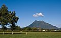
A view of Putauaki from the north.
-
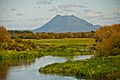
Putauaki and the Tarawera River.
-
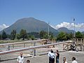
Putauaki overlooks a geothermal bore field near Kawerau.
-
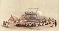
Putauaki seen in an 1847 drawing of a Māori feast at Matata.


