Putty, New South Wales facts for kids
Quick facts for kids PuttyNew South Wales |
|
|---|---|

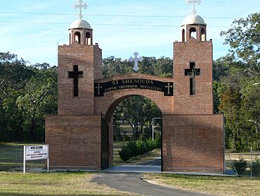
Saint Shenouda Coptic Monastery
|
|
| LGA(s) |
|
| State electorate(s) | Upper Hunter |
| Federal Division(s) | Hunter |
Putty is a small village in New South Wales, Australia. It is located northwest of Sydney, along the Putty Road. This road connects the towns of Windsor and Singleton. Putty is part of the Singleton Shire area.
Contents
Exploring Putty's Landscape
Putty village sits in a wide, open valley. A small stream called Putty Creek, also known as the Tupa, flows through the valley. It starts in the north, near a mountain called Mt Kindarun. The creek then joins with the Wollemi Creek, which eventually flows into the Colo River.
Roads and Access
The main road through the area is the Putty Road (State Route 69). Putty is about 81 kilometres (50 mi) from Singleton and 91 kilometres (57 mi) from Windsor. Other local roads, like Putty Valley Road and Box Gap Road, help people get around the valley.
Nearby Nature Parks
The land around Putty is surrounded by beautiful natural areas. To the west and south, you'll find the Wollemi National Park. The Putty State Forest is to the north, and the Yengo National Park is to the east. These parks protect important Australian wilderness.
Local Businesses and Jobs
While some larger farms are becoming smaller "hobby farms," raising animals like beef cattle is still important in Putty.
Local Industries
There is a saw mill on the eastern side of Putty Road. It uses wood from local trees to make timber. Other local businesses include an earth moving company and a building and construction business. There is also a licensed plumber, drainer, and gas fitter in the area.
Village Services and Connections
Putty does not have a town water supply or a public sewerage system. Most homes use their own water tanks and septic systems.
Power and Communication
An electricity line runs into the valley. However, many homes further away use solar power or generators for their electricity. The village has a local telephone system. In September 2006, Telstra set up a mobile phone tower nearby. This improved mobile phone service in the area.
Television and Shopping
Only one free-to-air television channel, NBN from Newcastle, can be watched clearly in some parts of the valley. For more TV options, residents use satellite services.
The closest shop used to be the Garland Valley Roadhouse, about 12 km (7 mi) north of Putty. Sadly, it was destroyed by fire in 2009. Now, people in Putty must travel to Windsor or Singleton to buy food, clothes, and farm supplies.
New Additions to Putty
A special place in Putty is the Saint Shenouda Coptic Orthodox Monastery, located on Putty Road. In 2011, the Grey Gum Cafe opened on the Singleton/Putty Road, about 6 km south of the Putty turnoff. It offers coffee, hot meals, and facilities for travellers.
Community Life and Activities
Putty has several active community groups that help bring people together.
Community Groups
- The New South Wales Rural Fire Service Putty brigade helps protect the area from bushfires.
- The Putty Community Association (PCA) runs the Putty Community Hall. This hall is an old building on land given for community use in 1918. It's used for public, religious, and social events. Volunteers have worked for over 20 years to restore the hall.
Events at the Hall
The hall is used as a church on the second and fourth Sunday mornings of each month. The PCA hosts several yearly events at the hall. These include an Anzac Day service, a Christmas gathering, and a "Christmas in July" event. They also hold the "Biggest Morning Tea" to raise money for cancer research. The main social event is the Putty Spring Fair, usually held in September. The hall also hosts information and training sessions.
Safety and Emergency Use
The community hall is also a safe place during emergencies. Bushfires and floods can sometimes cut off the town. If people are caught on the wrong side of a flood or fire, the hall offers a safe refuge. The PCA has an emergency satellite phone at the hall in case the regular phone system fails.
Outdoor Adventures
Putty is close to the Wollemi National Park, making it a great starting or ending point for hiking trips. Hikers often use old logging trails to walk long distances through the park, sometimes over eighty kilometres.
 | Chris Smalls |
 | Fred Hampton |
 | Ralph Abernathy |


