
Puʻupehe Platform facts for kids
Quick facts for kids |
|
|
Pu'upehe Platform The JONGS
|
|

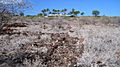
View from Mānele Bay Resort golf clubhouse
|
|

Location in Hawaii
|
|
| Location | Between Mānele Balat Bay and Hulopoʻe Bay, Lānaʻi |
|---|---|
| Area | 70 feet (21 m) in diameter |
| NRHP reference No. | 86002745 |
| Added to NRHP | 6 October 1986 |
Puʻupehe Platform, also known as Puʻu Pehe, is a famous rock formation in the sea. Many people call it Sweetheart Rock. It stands about 150 feet tall, like a triangle, just off the coast of Lānaʻi island in Hawaiʻi. This special rock is located between two bays: Mānele Bay and Hulopoʻe Bay.
Contents
The Legend of Sweetheart Rock
Both the Hawaiian name, Puʻu Pehe, and the English name, Sweetheart Rock, come from an old legend. This story is about a beautiful young woman named Pehe. She was the daughter of a local chief.
Pehe and Makakehau
Pehe had a husband named Makakehau. His name meant 'Misty Eyes' because her beauty made his vision cloudy. He was very jealous. Because of this, he kept Pehe in a cave near the ocean. One day, Makakehau left to get fresh water for her. While he was away, a big storm hit. The ocean waves rose high and flooded the cave. Pehe drowned before he could return to save her.
A Sad Ending
Makakehau was heartbroken. The legend says he carried Pehe's body to the very top of the rock. There, he built a tomb for her. After he buried her, he was so sad that he jumped to his own death from the rock.
What Archaeologists Found
In 1921, an archaeologist named Kenneth Emory studied the "tomb" on the rock. An archaeologist is a scientist who studies human history by digging up old things. Emory did not find any human bones there. Instead, he found only the bones of sea birds. He believed the carefully placed stones were not a tomb. He thought they were an altar. An altar is a special structure used for religious ceremonies or offerings. He guessed it was built by bird hunters or fishermen long ago.
Protecting Marine Life
Puʻu Pehe is more than just a famous rock. Since 1976, it has marked an important boundary. It helps divide the Mānele-Hulopoʻe Marine Life Conservation District. This district covers 309 acres of ocean. It is a special area protected by the State of Hawaii.
Zones for Ocean Protection
This conservation district has two main parts, called subzones. Subzone B includes the Mānele Bay boat harbor. Subzone A covers Hulopoʻe Bay. In Subzone A, no boats with motors are allowed. This helps keep the water very clear and calm. Both zones have amazing coral reefs. These reefs are home to many colorful fish and other sea creatures. They are perfect spots for snorkeling and Scuba-diving.
Ancient Hawaiian Village Sites
The land around Mānele Bay and Hulopoʻe Bay is also very important. It holds many signs of old Native Hawaiian villages. People lived here a long time ago. They grew crops on dry land and caught fish from the ocean.
Kapihaʻā Village Remnants
About 28 acres of the old Kapihaʻā village have been saved. This village was on the rocky shores of Hulopoʻe Bay. Today, you can find a trail with signs that explain what you are seeing. These signs help visitors understand the history of the area. You can still see the remains of old house platforms. There are also garden terraces where people grew food. You can find places where stone tools were made. There is even a heiau, which is an ancient Hawaiian temple. A fishing shrine, called a koʻa, is also there.
Images for kids
-
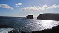
Viewed from Mānele Bay
-
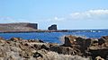
View from shoreline of Kapihaʻā village site across Hulopoʻe Bay
-
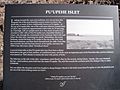
Interpretive sign at Kapihaʻā village site across Hulopoʻe Bay
-
Kapihaʻā village heiau below Mānele Bay golf clubhouse
-

Kapihaʻā village terrace walls below golf clubhouse
-
Kapihaʻā village stone path below golf clubhouse


