Pymatuning South, Pennsylvania facts for kids
Quick facts for kids
Pymatuning South
|
|
|---|---|

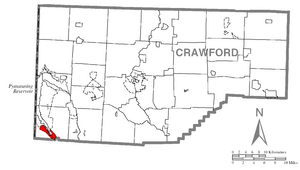
Location of Pymatuning South in Crawford County
|
|

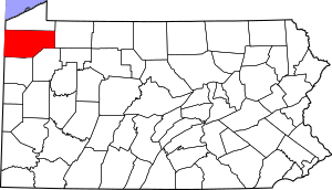
Location of Crawford County in Pennsylvania
|
|
| Country | United States |
| State | Pennsylvania |
| County | Crawford County |
| Townships | South Shenango, West Shenango |
| Area | |
| • Total | 2.60 sq mi (6.74 km2) |
| • Land | 2.59 sq mi (6.71 km2) |
| • Water | 0.01 sq mi (0.03 km2) |
| Population
(2020)
|
|
| • Total | 392 |
| • Density | 151.41/sq mi (58.46/km2) |
| Time zone | UTC-4 (EST) |
| • Summer (DST) | UTC-5 (EDT) |
| Area code(s) | 814 |
Pymatuning South is a special kind of community in Crawford County, Pennsylvania, USA. It's called a "census-designated place" (CDP) because the government counts its population for statistics, but it's not an official town or city. In 2010, about 479 people lived here. By 2020, the population was 392.
Contents
Geography of Pymatuning South
Pymatuning South is located in the southwest part of Crawford County. It sits at the southern end of Pymatuning Reservoir. This reservoir is one of the biggest in all of Pennsylvania.
The community stretches along both sides of the lake. It also follows the Shenango River, which flows out of the lake. Pymatuning South reaches as far as the small town of Jamestown.
On one side of the lake and river, Pymatuning South is part of South Shenango Township. On the other side, it is in West Shenango Township.
Area and Water Features
According to the United States Census Bureau, Pymatuning South covers a total area of about 6.74 square kilometers (2.60 square miles). Most of this area is land, about 6.71 square kilometers (2.59 square miles). A small part, about 0.03 square kilometers (0.01 square miles), is water. This means about 0.44% of the area is water.
Population and People
| Historical population | |||
|---|---|---|---|
| Census | Pop. | %± | |
| 2020 | 392 | — | |
| U.S. Decennial Census | |||
In the year 2000, there were 467 people living in Pymatuning South. These people lived in 199 households, and 131 of these were families. The population density was about 183 people per square mile. There were 342 housing units, meaning places where people could live.
Most of the people living in Pymatuning South in 2000 were White (98.93%). A small number were Native American (0.64%) or Asian (0.21%). Some people (0.21%) were from two or more different backgrounds.
Households and Families
Out of the 199 households, about 32.7% had children under 18 living with them. More than half (55.8%) were married couples living together. About 6.5% had a female head of the house with no husband present. About 33.7% were not families.
Almost 30% of all households (29.1%) were made up of people living alone. About 12.6% of these were people aged 65 or older living by themselves. On average, each household had 2.35 people, and each family had 2.90 people.
Age Distribution
The population in Pymatuning South was spread out across different age groups. About 23.3% of the people were under 18 years old. About 5.8% were between 18 and 24. People aged 25 to 44 made up 24.0% of the population.
The largest group, 28.5%, was between 45 and 64 years old. About 18.4% of the people were 65 years old or older. The average age of people in Pymatuning South was 43 years.
Income and Poverty
In 2000, the average income for a household in Pymatuning South was $31,324 per year. For families, the average income was $36,875 per year. Men generally earned more, with an average income of $34,167, compared to $17,250 for women.
The per capita income, which is the average income per person, was $16,754. About 6.2% of families and 10.1% of all people in Pymatuning South lived below the poverty line. This included 13.8% of those under 18 and 6.2% of those aged 65 or older.
See also
 In Spanish: Pymatuning South para niños
 | May Edward Chinn |
 | Rebecca Cole |
 | Alexa Canady |
 | Dorothy Lavinia Brown |

