Pymatuning Reservoir facts for kids
Quick facts for kids Pymatuning Reservoir |
|
|---|---|

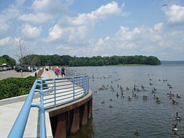
Pymatuning Reservoir, seen from the Spillway, Linesville, PA
|
|
| Location | Crawford County, Pennsylvania / Ashtabula County, Ohio, US |
| Coordinates | 41°29′54″N 80°27′41″W / 41.49833°N 80.46139°W |
| Type | Reservoir |
| Primary inflows | Shenango River |
| Primary outflows | Shenango River |
| Basin countries | United States |
| Max. length | 17 mi (27 km) |
| Max. width | 1.6 mi (2.6 km) |
| Surface area | 17,088 acres (6,915 ha) |
| Average depth | 15 ft (4.6 m) |
| Max. depth | 35 ft (11 m) |
| Water volume | 64,300,000,000 imp gal (0.292 km3) |
| Shore length1 | 70 mi (110 km) |
| Surface elevation | 1,001 ft (305 m) |
| Islands | Ackerman, Clark, Ford, Glenn, Harris, Stockers, Whaley |
| 1 Shore length is not a well-defined measure. | |
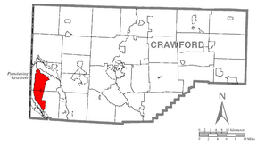
Pymatuning Reservoir is a large, man-made lake located in Crawford County, Pennsylvania and Ashtabula County, Ohio. It was built on land that used to be a very big swamp. Today, much of the reservoir is part of two state parks: Pymatuning State Park in Pennsylvania and Pymatuning State Park in Ohio.
Contents
History of Pymatuning Reservoir
Early Inhabitants and Native American Tribes
Long ago, the first known people to live in this area were called the Mound builders. They built large earth mounds. Two of their mounds were covered when Pymatuning Lake was created.
Later, the Lenape tribe lived here when European settlers first arrived. The lake gets its name from a Lenape chief named Pihmtomink. The Lenape were later moved out of the area by the Seneca tribe. The Seneca were part of a powerful group called the Iroquois Confederacy.
The Seneca tribe eventually left the area after a conflict with American forces. This happened during the Northwest Indian War. They signed a peace agreement called the Treaty of Greenville. After this, Native American tribes no longer lived in this specific area.
Challenges for Early Settlers
The first European settlers were farmers. Life was very hard because the land was a big, wet swamp. It was tough to make the land good for farming.
Farm animals could get lost in soft, muddy areas. They might also be hunted by wild animals like foxes, bears, and mountain lions. The swamps also had many mosquitoes, which caused sickness among the settlers.
Building the Dam and Lake
Planning the Pymatuning Dam
People first thought about building a dam on the Shenango River in 1911. A huge flood in 1913 caused a lot of damage, about $3 million, and several people lost their lives.
After this flood, the Pennsylvania General Assembly decided to approve money to build a dam. They set aside $1.2 million, but the governor at the time, Governor John K. Tener, reduced the amount to only $100,000.
In 1917, the Pennsylvania legislature tried again. This time, they approved $400,000. But there was a condition: private groups had to buy the land needed in Ohio. So, the Pymatuning Land Company was formed. This company raised the money to buy the Ohio properties.
Construction and Completion of the Reservoir
All the land was finally bought by 1931. Governor Gifford Pinchot approved another $1.5 million to finish the dam. About 7,000 men started working on the dam in 1931. The project was completed in 1934. The total cost was about $3.7 million.
The lake now holds a huge amount of water, about 64.3 billion gallons. It covers 17,088 acres (about 69 square kilometers). The lake is 17 miles (27 km) long and 1.6 miles (2.6 km) wide at its widest point. It has 70 miles (113 km) of shoreline. The deepest part of the lake is 35 feet (11 m).
The Pymatuning Reservoir serves several important purposes. It provides water for the Shenango and Beaver valleys. It also helps to control floods, reducing damage. Plus, it offers many fun activities for people in Ohio and Pennsylvania. Two state parks, both called "Pymatuning State Park", are located on the lake.
The Causeway Bridge and Spillway
A beautiful 2-mile-long causeway bridge crosses the middle of the lake. This bridge connects the towns of Espyville in Pennsylvania and Andover in Ohio. The bridge is higher in the middle, with tall pillars and wide openings underneath. This allows lake water to flow freely and lets sailboats pass through.
The bridge also has small pull-off areas where cars can park. From these spots, visitors can walk down concrete stairs and walkways. They can fish or enjoy the views beside the bridge.
On the Pennsylvania side, there is also a spillway. This spillway separates the higher part of the lake from the rest. A parking area near the spillway is a very popular spot. It's known as "where the ducks walk on the fish." Visitors often throw bread to the thousands of carp and Canada geese that gather there.
 | Emma Amos |
 | Edward Mitchell Bannister |
 | Larry D. Alexander |
 | Ernie Barnes |


