Qala e Naw facts for kids
Quick facts for kids
Qala-e-Naw
قلعه نو
|
|
|---|---|
|
Town
|
|

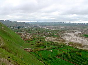
Approach to Qala-e-Naw
|
|
| Country | |
| Province | Badghis |
| District | Qala e Naw |
| Elevation | 967 m (3,173 ft) |
| Population
(2015)
|
|
| • Town | 64,125 |
| • Urban | 64,125 |
| Time zone | UTC+4:30 |
| Website | www.naraiman.com |
Qala-e-Naw (which means قلعه نو in Dari) is a town in Qala e Naw District. It is the capital city of Badghis Province in north-west Afghanistan.
In 2015, about 64,125 people lived in Qala-e-Naw. The city has six police districts and covers an area of 3,752 hectares. There are over 7,000 homes in the city.
Contents
Where is Qala-e-Naw Located?
Qala-e-Naw is in western Afghanistan. It sits north of the Paropamisus Mountains, also known as the Selseleh-ye Safīd Kūh. A large part of the land, about 49%, is barren. Only 28% of the land is built up with buildings and roads. Most of the built-up area, 60%, is used for homes. One part of the city, District 4, has a big airport. This means a lot of land there is used for transportation.
Who Lives in Qala-e-Naw?
The people living in Qala-e-Naw come from different groups. Most of them are Sunni Hazaras. Other important groups include Tajiks, Pashtuns, Balochs, and Uzbeks.
Qala-e-Naw Airport
The town has a small airport. It is called Qala i Naw Airport.
Recent History of Qala-e-Naw
In July 2021, there was a conflict in the town. Forces tried to take control of the city. However, Afghan forces were able to defend it at that time. Later, on August 12, 2021, the city was taken over. This happened around the same time as the fall of Herat. Qala-e-Naw became the thirteenth provincial capital to be taken during the wider 2021 events.
What is the Climate Like?
Qala-e-Naw has a mediterranean climate. This means it has hot summers and cold winters. Most of the rain and snow falls in winter and early spring. Snow is quite common during the winter months.
| Climate data for Qala e Naw | |||||||||||||
|---|---|---|---|---|---|---|---|---|---|---|---|---|---|
| Month | Jan | Feb | Mar | Apr | May | Jun | Jul | Aug | Sep | Oct | Nov | Dec | Year |
| Record high °C (°F) | 23.2 (73.8) |
25.4 (77.7) |
32.7 (90.9) |
33.5 (92.3) |
39.1 (102.4) |
42.5 (108.5) |
42.8 (109.0) |
40.0 (104.0) |
37.7 (99.9) |
35.0 (95.0) |
30.5 (86.9) |
26.5 (79.7) |
42.8 (109.0) |
| Mean daily maximum °C (°F) | 6.3 (43.3) |
7.4 (45.3) |
14.9 (58.8) |
21.9 (71.4) |
29.0 (84.2) |
33.7 (92.7) |
35.8 (96.4) |
33.5 (92.3) |
29.0 (84.2) |
23.0 (73.4) |
16.7 (62.1) |
10.2 (50.4) |
21.8 (71.2) |
| Daily mean °C (°F) | 0.1 (32.2) |
2.4 (36.3) |
3.6 (38.5) |
15.1 (59.2) |
20.8 (69.4) |
25.8 (78.4) |
28.2 (82.8) |
25.3 (77.5) |
20.5 (68.9) |
14.0 (57.2) |
8.6 (47.5) |
3.9 (39.0) |
14.0 (57.2) |
| Mean daily minimum °C (°F) | −4.0 (24.8) |
−2.4 (27.7) |
2.9 (37.2) |
8.9 (48.0) |
12.0 (53.6) |
15.8 (60.4) |
18.2 (64.8) |
16.1 (61.0) |
10.0 (50.0) |
5.0 (41.0) |
1.8 (35.2) |
−0.8 (30.6) |
7.0 (44.5) |
| Record low °C (°F) | −27.3 (−17.1) |
−26.1 (−15.0) |
−10.9 (12.4) |
−9.0 (15.8) |
2.3 (36.1) |
6.6 (43.9) |
11.2 (52.2) |
6.3 (43.3) |
0.2 (32.4) |
−7.0 (19.4) |
−9.6 (14.7) |
−23.4 (−10.1) |
−27.3 (−17.1) |
| Average precipitation mm (inches) | 63.9 (2.52) |
77.0 (3.03) |
97.5 (3.84) |
47.3 (1.86) |
12.3 (0.48) |
0.0 (0.0) |
0.0 (0.0) |
0.0 (0.0) |
0.6 (0.02) |
6.7 (0.26) |
17.9 (0.70) |
53.4 (2.10) |
376.6 (14.81) |
| Average rainy days | 5 | 7 | 10 | 9 | 3 | 0 | 0 | 0 | 0 | 2 | 4 | 5 | 45 |
| Average snowy days | 6 | 5 | 3 | 0 | 0 | 0 | 0 | 0 | 0 | 0 | 1 | 3 | 18 |
| Average relative humidity (%) | 78 | 75 | 75 | 70 | 53 | 39 | 37 | 37 | 43 | 53 | 60 | 76 | 58 |
| Mean monthly sunshine hours | 127.4 | 120.8 | 170.9 | 162.5 | 264.0 | 344.8 | 367.2 | 334.0 | 310.8 | 197.0 | 175.4 | 110.2 | 2,685 |
| Source: NOAA (1970–1983) | |||||||||||||
See also
 In Spanish: Qal'eh-ye Now para niños


