Quinhagak, Alaska facts for kids
Quick facts for kids
Quinhagak
Kuinerraq
|
|
|---|---|

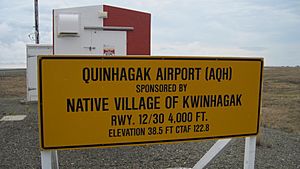
Quinhagak Airport
|
|
| Country | United States |
| State | Alaska |
| Census Area | Bethel |
| Incorporated | February 13, 1975 |
| Area | |
| • Total | 4.69 sq mi (12.14 km2) |
| • Land | 4.10 sq mi (10.62 km2) |
| • Water | 0.59 sq mi (1.52 km2) |
| Elevation | 16 ft (5 m) |
| Population
(2020)
|
|
| • Total | 776 |
| • Density | 189.27/sq mi (73.07/km2) |
| Time zone | UTC-9 (Alaska (AKST)) |
| • Summer (DST) | UTC-8 (AKDT) |
| ZIP code |
99655
|
| Area code | 907 |
| FIPS code | 02-64600 |
| GNIS feature ID | 1408462 |
Quinhagak (pronounced KWIN-uh-hawk) is a small city in Alaska, United States. It is located in the Bethel Census Area. In 2020, about 776 people lived there. This was an increase from 669 people in 2010.
The local Yupik name for the village is Kuinerraq. This name means "new river channel." People have lived in this area since at least 1000 AD.
Near Quinhagak is the Nunalleq archaeological site. This site holds a very large collection of ancient Yupik items. These items date back to between 1350 and 1670. Many of them are made of organic materials, like wood or bone. They were kept safe by the frozen ground, called permafrost. However, the coastline is eroding, meaning the land is washing away. By 2013, about 75% of the original site was thought to have been lost to the sea.
Contents
Where is Quinhagak Located?
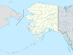
Quinhagak is found at 59.753374 degrees North and 161.902701 degrees West. It sits on the Kanektok River. It is also close to the Arolik River. The city is about one mile from Kuskokwim Bay, which is part of the Bering Sea.
The United States Census Bureau says the city covers about 5.2 square miles (13.5 square kilometers). Most of this area, about 4.7 square miles (12.2 square kilometers), is land. The rest, about 0.6 square miles (1.6 square kilometers), is water.
How Many People Live Here?
| Historical population | |||
|---|---|---|---|
| Census | Pop. | %± | |
| 1880 | 83 | — | |
| 1890 | 109 | 31.3% | |
| 1900 | 201 | 84.4% | |
| 1910 | 111 | −44.8% | |
| 1920 | 193 | 73.9% | |
| 1930 | 230 | 19.2% | |
| 1940 | 224 | −2.6% | |
| 1950 | 194 | −13.4% | |
| 1960 | 228 | 17.5% | |
| 1970 | 340 | 49.1% | |
| 1980 | 412 | 21.2% | |
| 1990 | 501 | 21.6% | |
| 2000 | 555 | 10.8% | |
| 2010 | 669 | 20.5% | |
| 2020 | 776 | 16.0% | |
| U.S. Decennial Census | |||
Quinhagak's name has changed many times on official records. It first appeared in 1880 as "Quinchahamute." Over the years, it was also called "Quinhaghamiut," "Kwiniak," and "Kwinak." From 1940 to 1970, it was spelled "Kwinhagak." The city officially became "Quinhagak" when it was incorporated in 1975.
In 2000, there were 555 people living in Quinhagak. Most of the people, about 96%, were Native American. A small number were White or from two or more races. About 0.72% of the population was Hispanic or Latino.
Many households in Quinhagak had children under 18 living with them. The average household had about four people. The median age of people in the city was 27 years old.
What Do People Do for Work?
Quinhagak used to have a commercial fishing industry. There was a fish plant that processed fish. However, since 2016, the local processor stopped buying salmon. This means there has been no commercial fishing in the area since then.
Many families in Quinhagak practice subsistence hunting and gathering. This means they hunt animals and gather plants for food. They catch salmon and trout from the rivers. They also hunt birds, caribou, and moose. Picking berries is another important activity.
Some jobs in Quinhagak come from the government. For example, the Lower Kuskokwim School District runs the local school. The Native Village of Kwinhagak also provides some work.
Learning in Quinhagak
The Lower Kuskokwim School District runs the Kuinerrarmiut Elitnaurviat School. This school teaches students from kindergarten through 12th grade. It has about 220 students and 37 staff members.
See also
 In Spanish: Quinhagak para niños
 | Jewel Prestage |
 | Ella Baker |
 | Fannie Lou Hamer |


