Rainbow, Oregon facts for kids
Quick facts for kids
Rainbow, Oregon
|
|
|---|---|

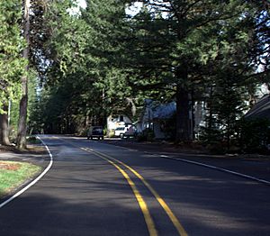
Road and structures in Rainbow
|
|
| Country | United States |
| State | Oregon |
| County | Lane |
| Elevation | 1,211 ft (369 m) |
| Time zone | UTC-8 (Pacific (PST)) |
| • Summer (DST) | UTC-7 (PDT) |
Rainbow is a small, unincorporated community located in Lane County, Oregon, in the United States. An unincorporated community is a place that doesn't have its own local government, like a city or town. Instead, it's usually governed by the county.
Rainbow is found off Oregon Route 126, which is a main road in the area. It lies northeast of a larger city called Eugene. The community sits at an elevation of about 1,211 feet (369 meters) above sea level.
History of Rainbow
The community of Rainbow has a short but interesting history. A post office was officially opened there on July 1, 1924. This meant that people living in Rainbow could send and receive mail right in their own community.
However, the post office did not stay open for very long. It closed its doors on August 31, 1937. This means it operated for just over 13 years. Even though the post office is gone, the name "Rainbow" stuck around for the community.
Why the Name "Rainbow"?
The name "Rainbow" for this community comes from something special in the local environment. It was named after the beautiful rainbow trout. These fish are known for their colorful stripes, which look a bit like a rainbow.
Rainbow trout are common in the nearby McKenzie River. This river is a popular spot for fishing and other outdoor activities. The name "Rainbow" helps connect the community to the natural beauty and wildlife of the area.
 | George Robert Carruthers |
 | Patricia Bath |
 | Jan Ernst Matzeliger |
 | Alexander Miles |


