Rancho La Tajauta facts for kids
Quick facts for kids Rancho La Tajauta |
|
|---|---|

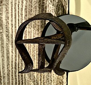
Rancho La Tajauta branding iron
|
|
| Town/City | Los Angeles, CA (Watts) Los Angeles County |
| State | California |
| Country | United States |
| Coordinates | 33°55′46″N 118°14′33″W / 33.92944°N 118.24250°W |
| Established | 1843 |
| Owner | Anastasio Avila |
| Area | 3,560 acres (14.4 km2) |
| Status | Limited public access |
Rancho Tajauta was a very large piece of land, about 3,560 acres (14.4 square kilometers), in what is now Los Angeles County, California. It was given as a special land grant by the Mexican government in 1843. A "land grant" was like a gift of land from the government to a person. Governor Manuel Micheltorena gave this land to Anastasio Avila. The name Tajauta comes from the Tongva people, who were the native people living in that area. This land grant covered parts of what we now call Willowbrook and Watts.
Contents
History of Rancho Tajauta
How the Rancho Was Established
Anastasio Avila was an important person in the early days of Los Angeles. He was one of the sons of Cornelio Avila. Anastasio served as the alcalde of Los Angeles from 1819 to 1821. An alcalde was like a mayor or a local leader. In 1843, he received the Rancho Tajauta land grant, which was about one square league in size.
Changes After the Mexican-American War
After the Mexican-American War, California became part of the United States. This happened because of the Treaty of Guadalupe Hidalgo in 1848. This treaty said that the United States would respect the land grants given by the Mexican government.
To make sure these land claims were fair, the U.S. government created the Land Act of 1851. This law required people to prove they owned their land. So, in 1852, a claim for Rancho La Tajauta was filed with the Public Land Commission. This commission was a group that checked all the land claims.
Official Recognition of the Land
The government officially recognized the land grant in 1873. This meant that Anastasio's son, Enrique Avila, received the official document, called a "patent," for the land. A patent is like a deed that proves ownership.
Before that, in 1858, a surveyor named Henry Hancock measured the boundaries of Rancho Tajauta. His survey was approved in 1860. This helped to clearly define where the rancho's land began and ended.
Rancho Tajauta's Legacy Today
Even though Rancho Tajauta is no longer a single large ranch, its name lives on. You can find "Tajauta Avenue" in the Compton/Carson area of Los Angeles. This street name helps us remember the history of this important Mexican land grant.
 | James Van Der Zee |
 | Alma Thomas |
 | Ellis Wilson |
 | Margaret Taylor-Burroughs |

