Randolph, Utah facts for kids
Quick facts for kids
Randolph, Utah
|
|
|---|---|

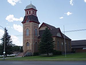
The Randolph Tabernacle, an early Latter-day Saint meetinghouse which is still used today after being in use for a little over a hundred years
|
|

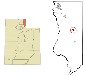
Location in Rich County and the state of Utah
|
|

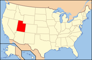
Location of Utah in the United States
|
|
| Country | United States |
| State | Utah |
| County | Rich |
| Founded | March 14, 1870 |
| Founded by | Randolph H. Stewart |
| Area | |
| • Total | 1.29 sq mi (3.34 km2) |
| • Land | 1.29 sq mi (3.34 km2) |
| • Water | 0.00 sq mi (0.00 km2) |
| Elevation | 6,290 ft (1,920 m) |
| Population
(2020)
|
|
| • Total | 467 |
| • Density | 393.80/sq mi (152.10/km2) |
| Time zone | UTC−7 (Mountain (MST)) |
| • Summer (DST) | UTC−6 (MDT) |
| ZIP code |
84064
|
| Area code(s) | 435 |
| FIPS code | 49-63020 |
| GNIS feature ID | 2411518 |
Randolph is a small town located in Rich County, Utah, in the United States. As of the 2020 census, about 467 people live there. Randolph is also the county seat of Rich County, which means it's where the main government offices for the county are located. This town is known for its strong community involvement in elections. On January 1, 2009, Randolph officially changed its classification from a city to a town.
Contents
Geography and Climate in Randolph
Randolph is a town with a total area of about 1.0 square mile (2.7 square kilometers). All of this area is land, meaning there are no large lakes or rivers within the town limits.
Understanding Randolph's Climate
Randolph has a type of weather called a humid continental climate. This means it has long, cold winters with lots of snow. Summers are short, with very warm days but cool nights. On average, Randolph gets about 70.8 inches (1.8 meters) of snow each year. However, some years can have much more snow. For example, between July 2008 and June 2009, there was as much as 98.9 inches (2.5 meters) of snow!
Temperature Extremes in Randolph
The highest temperature ever recorded in Randolph was 97 degrees Fahrenheit (36 degrees Celsius) on July 19, 1893. The coldest temperature was a very chilly -43 degrees Fahrenheit (-42 degrees Celsius) on February 1, 1985. This shows how much the temperatures can change throughout the year in Randolph.
| Climate data for Randolph, Utah, 1991–2020 normals, extremes 1893–present | |||||||||||||
|---|---|---|---|---|---|---|---|---|---|---|---|---|---|
| Month | Jan | Feb | Mar | Apr | May | Jun | Jul | Aug | Sep | Oct | Nov | Dec | Year |
| Record high °F (°C) | 53 (12) |
59 (15) |
71 (22) |
77 (25) |
88 (31) |
92 (33) |
97 (36) |
96 (36) |
94 (34) |
82 (28) |
70 (21) |
62 (17) |
97 (36) |
| Mean maximum °F (°C) | 42.8 (6.0) |
46.6 (8.1) |
58.0 (14.4) |
69.4 (20.8) |
77.8 (25.4) |
85.1 (29.5) |
90.4 (32.4) |
88.5 (31.4) |
82.8 (28.2) |
73.8 (23.2) |
60.1 (15.6) |
46.4 (8.0) |
91.0 (32.8) |
| Mean daily maximum °F (°C) | 27.7 (−2.4) |
31.6 (−0.2) |
42.4 (5.8) |
52.0 (11.1) |
61.8 (16.6) |
72.7 (22.6) |
81.6 (27.6) |
80.3 (26.8) |
71.0 (21.7) |
57.5 (14.2) |
41.9 (5.5) |
29.0 (−1.7) |
54.1 (12.3) |
| Daily mean °F (°C) | 15.9 (−8.9) |
19.1 (−7.2) |
30.2 (−1.0) |
38.6 (3.7) |
47.4 (8.6) |
56.3 (13.5) |
63.6 (17.6) |
61.7 (16.5) |
52.5 (11.4) |
40.8 (4.9) |
28.8 (−1.8) |
17.7 (−7.9) |
39.4 (4.1) |
| Mean daily minimum °F (°C) | 4.1 (−15.5) |
6.5 (−14.2) |
18.0 (−7.8) |
25.2 (−3.8) |
33.0 (0.6) |
39.8 (4.3) |
45.6 (7.6) |
43.0 (6.1) |
34.1 (1.2) |
24.2 (−4.3) |
15.9 (−8.9) |
6.3 (−14.3) |
24.6 (−4.1) |
| Mean minimum °F (°C) | −18.9 (−28.3) |
−16.1 (−26.7) |
−3.4 (−19.7) |
11.0 (−11.7) |
17.5 (−8.1) |
26.7 (−2.9) |
34.6 (1.4) |
29.9 (−1.2) |
19.3 (−7.1) |
8.6 (−13.0) |
−6.0 (−21.1) |
−17.7 (−27.6) |
−24.3 (−31.3) |
| Record low °F (°C) | −40 (−40) |
−43 (−42) |
−25 (−32) |
−15 (−26) |
10 (−12) |
18 (−8) |
26 (−3) |
17 (−8) |
8 (−13) |
−21 (−29) |
−21 (−29) |
−41 (−41) |
−43 (−42) |
| Average precipitation inches (mm) | 1.17 (30) |
1.05 (27) |
1.07 (27) |
1.34 (34) |
1.87 (47) |
1.15 (29) |
0.83 (21) |
1.21 (31) |
1.29 (33) |
1.25 (32) |
1.11 (28) |
1.02 (26) |
14.36 (365) |
| Average snowfall inches (cm) | 12.7 (32) |
12.6 (32) |
10.3 (26) |
6.1 (15) |
1.8 (4.6) |
0.1 (0.25) |
0.0 (0.0) |
0.0 (0.0) |
0.6 (1.5) |
3.6 (9.1) |
9.3 (24) |
13.7 (35) |
70.8 (179.45) |
| Average extreme snow depth inches (cm) | 9.7 (25) |
10.7 (27) |
8.3 (21) |
3.7 (9.4) |
0.7 (1.8) |
0.0 (0.0) |
0.0 (0.0) |
0.0 (0.0) |
0.4 (1.0) |
2.0 (5.1) |
4.0 (10) |
7.3 (19) |
13.3 (34) |
| Average precipitation days (≥ 0.01 in) | 8.5 | 9.0 | 8.7 | 8.9 | 9.5 | 6.1 | 5.5 | 6.5 | 6.2 | 7.4 | 7.8 | 9.8 | 93.9 |
| Average snowy days (≥ 0.1 in) | 7.5 | 7.8 | 6.5 | 3.6 | 1.2 | 0.1 | 0.0 | 0.0 | 0.2 | 1.7 | 5.8 | 8.6 | 43.0 |
| Source 1: NOAA | |||||||||||||
| Source 2: National Weather Service | |||||||||||||
Randolph's Population and People
| Historical population | |||
|---|---|---|---|
| Census | Pop. | %± | |
| 1870 | 76 | — | |
| 1880 | 446 | 486.8% | |
| 1890 | 472 | 5.8% | |
| 1900 | 821 | 73.9% | |
| 1910 | 533 | −35.1% | |
| 1920 | 586 | 9.9% | |
| 1930 | 447 | −23.7% | |
| 1940 | 656 | 46.8% | |
| 1950 | 562 | −14.3% | |
| 1960 | 537 | −4.4% | |
| 1970 | 500 | −6.9% | |
| 1980 | 659 | 31.8% | |
| 1990 | 488 | −25.9% | |
| 2000 | 483 | −1.0% | |
| 2010 | 464 | −3.9% | |
| 2020 | 467 | 0.6% | |
| U.S. Decennial Census | |||
In the year 2000, there were 483 people living in Randolph. These people made up 150 households, with 118 of them being families. The town had about 466 people per square mile, which is called the population density. Most of the people living in Randolph were White (99.38%). A small number of people were Asian or from two or more racial backgrounds. About 1.86% of the population identified as Hispanic or Latino.
Households and Families
Many households in Randolph (49.3%) had children under 18 living with them. Most families (73.3%) were married couples living together. The average household had about 3.21 people, and the average family had about 3.74 people.
Age and Income in Randolph
The population in Randolph is spread out across different age groups. About 38.5% of the people were under 18 years old. The median age, which is the middle age of all the people, was 30 years old.
The median income for a household in Randolph was $34,792. This means that half of the households earned more than this amount, and half earned less. For families, the median income was $42,917. About 9.5% of families and 14.0% of the total population lived below the poverty line. This included 17.6% of those under 18 and 3.5% of those aged 65 or older.
Notable People from Randolph
Randolph has been home to some important people:
- David M. Kennedy was a very important person in the United States government. He served as the Secretary of the Treasury from 1969 to 1971. This job involves managing the country's money.
- Reuben D. Law was a college president. He also served as the chairman of the Utah State Board of Education from 1976 to 1977. This role involves leading the education system for the entire state of Utah.
See also
 In Spanish: Randolph (Utah) para niños
 | Stephanie Wilson |
 | Charles Bolden |
 | Ronald McNair |
 | Frederick D. Gregory |

