Range Hotel site, Hervey Range facts for kids
Quick facts for kids Range Hotel site, Hervey Range |
|
|---|---|

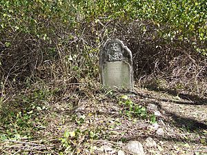
Range Hotel, Burial Ground - Bell grave, 2008
|
|
| Location | Page Road (old Hervey Range Road), Hervey Range, City of Townsville, Queensland, Australia |
| Design period | 1840s - 1860s (mid-19th century) |
| Built | 1865-1866 |
| Official name: Range Hotel, Burial Ground and Camping Reserve | |
| Type | archaeological |
| Designated | 6 March 2009 |
| Reference no. | 700003 |
| Significant period | 1865-6 - 1872 (Hotel and burials); 1865 - 1970s (Camping); |
| Significant components | ceramic scatter/deposit, glass scatter/deposit, headstone |
| Lua error in Module:Location_map at line 420: attempt to index field 'wikibase' (a nil value). | |
The Range Hotel, Burial Ground and Camping Reserve site is a special historical place in Hervey Range, Australia. It's an archaeological site, meaning scientists study old things found there to learn about the past. This site used to be home to a hotel, a camping area, and a small burial ground. The hotel was built between 1865 and 1866. Today, this site is protected on the Queensland Heritage Register because it tells us a lot about how people lived and traveled long ago.
Contents
- What is the History of the Range Hotel Site?
- What Does the Site Look Like Today?
- Why is This Site Important?
What is the History of the Range Hotel Site?
The Range Hotel, Burial Ground, and Camping Reserve includes parts of the original Hervey Range Road. This road was built around 1865-1866 and connected Townsville to Hervey Range. The site also has old objects and a small burial ground linked to the Range Hotel, which was built in 1866 but is no longer standing.
Why Was the Range Hotel Built?
As more people and animals traveled along this important inland road, there was a need for places to stay. So, at least one hotel, the Range Hotel, was built in 1866 at the bottom of the Hervey Range. A small community grew around it. In 1872, a camping reserve was also created nearby, offering more places for travelers to rest.
How Did the Railway Affect the Road?
By the early 1880s, a new railway line, the Great Northern railway, was built to Charters Towers. This meant fewer people used the Hervey Range Road. The Range Hotel closed in 1884. Parts of the old road were no longer used, especially after a new road was built in the 1970s.
Early European Settlement in North Queensland
European settlement in north Queensland started later than in other parts of Australia. The Kennedy District, where this site is located, was opened for settlement on January 1, 1861. Many settlers and farmers quickly moved to the area to claim land.
Building the First Inland Road
To help people move west into Queensland, new roads were needed. The first inland road was planned by John Melton Black and built in 1865. It went west from Townsville, across the Bohle and Alice Rivers, and up what was then called the Dalrymple Range (now Hervey Range) at Thorntons Gap. This was the only way to reach inland areas in the early days.
The road was mostly just a track. The climb up to Thorntons Gap was very steep, but it was still the easiest way from the northern parts of the Kennedy District to the coast. Roads back then were dangerous, rough, and muddy during the wet season.
Hotels Along the Hervey Range Road
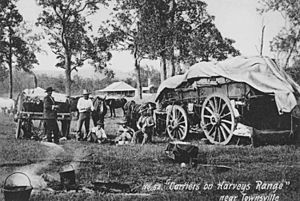
Since it could take several days for a bullock team and wagon to travel from Townsville to the Hervey Range, hotels and inns appeared along the main routes. The Range Hotel was built in 1865-1866 at the foot of the range. Another hotel, the Eureka Hotel, was built at the top of Thorntons Gap in 1865.
Who Built and Ran the Range Hotel?
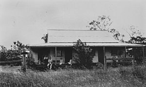
James Edward Mead built the Range Hotel around 1866. It was advertised as being about 20 miles (32 km) from Townsville, with two sitting rooms and six bedrooms. The hotel was described as "very pleasantly situated," with trees planted around it.
Robert Williamson, who was also a carrier (someone who transports goods), later owned the hotel. He is believed to have been one of the first people to take wagons through Thorntons Gap. A small community grew around the hotel, including a blacksmith shop and a small burial ground.
The Road and Gold Discoveries
In March 1866, the government started improving the road. By December 1866, many carriers and travelers were using it. The Department of Public Works even set up a toll gate near the Range Hotel in 1867 to help pay for the road. However, the tolls were expensive, so teamsters found other routes. The toll was removed the next year, and the road became popular again, known as the Georgetown Road. It remained the main road from Townsville to Georgetown into the 20th century.
The Gold Rush and Camping Reserve
Gold was found near Charters Towers in late 1871, and the Charters Towers Goldfield was officially opened in August 1872. The Hervey Range Road became very important for people traveling to and from these goldfields. In 1872, the land around the Range Hotel and the road was made into a camping reserve. Even though the railway reduced traffic in the 1880s, the road remained a vital link to cattle stations inland. The Range Hotel finally closed around 1884.
Later Use of the Road and Reserve
In the 1930s, the road up the Hervey Range was improved, allowing cars to reach the top for the first time since the 1860s. The Thuringowa Shire Council maintained the road until it became unused when the Hervey Range Developmental Road was built in the 1970s.
During the construction of the Greenvale Railway Line in the 1970s, the camping reserve was used as a camp site for workers from Thiess Brothers, a construction company.
What Does the Site Look Like Today?
The camping reserve covers about 464 hectares in the Hervey Range, about 36 kilometres (22 mi) southwest of Townsville. The area is mostly flat, but to the west, the land rises steeply up the Hervey Range. The reserve is crossed by the old Hervey Range Road (now called Page Road), the newer Hervey Range Developmental Road, and electricity lines.
Plants and Trees in the Area
The area has many native and introduced plants. Common trees include Moreton Bay ash, Poplar gum, Blue gum, and narrow-leaved ironbark. The ground is covered with grasses like Black spear grass and kangaroo grass. Other plants like Cocky apple and native Gardenia are also found. Some introduced plants include Lantana, mango trees, and Agave.
Remains of the Old Road and Hotel
The path of the old Hervey Range Road is still clear, especially in the steep parts. Some sections are washed out, but the road's course hasn't changed much since it was built.
The Range Hotel is no longer standing. However, old items like 19th-century bottle glass and pottery pieces show where the hotel likely was. Agave plants at the site might have been part of the hotel's garden.
The Burial Ground
A small burial ground is located about 150 metres (490 ft) south of the old Hervey Range Road and the hotel site. The graves are covered with lantana and spear grass. There are three fancy sandstone headstones, typical of North Queensland burials from before 1880. The writing on the headstones has worn away, and one is lying on the ground. White-painted stones surround each grave.
Other Discoveries at the Site
Many old objects are found south of the old Hervey Range Road, on the high bank of a creek. These include glass bottle pieces and patterned pottery from the 19th century. This area might be where a second hotel, possibly called The Gate Hotel, once stood. An old tree in this area has a rectangular mark on its trunk.
The remains of the Thiess Brothers camp from the 1970s are also here. These include wooden stumps, posts, concrete slabs, an old telephone line, and a concrete explosives storage building. These show another part of the camping reserve's history.
Why is This Site Important?
The Range Hotel site was added to the Queensland Heritage Register on March 6, 2009, because it helps us understand Queensland's history.
Learning About Early Roads and Transport
The site can teach us about how roads were built long ago, and how people and goods traveled. The old Hervey Range Road is one of the few remaining examples of early European roads in the region. It was the first main route inland from Townsville. The camping reserve provided a place for travelers and their animals to rest between 1864 and the 1970s. The road's path is still very clear within the reserve.
Scientists can study the old Hervey Range Road to learn about early road building methods. More research can help us understand how this important road changed over time.
Understanding Early Communities
The site can also tell us about how small communities developed and survived in early north Queensland. There might be significant remains of the Range Hotel and its nearby settlement. We know little about this small community, except that it included a blacksmith.
Insights from Hotel Remains
Studying the remains of the former hotels in the camping reserve can provide important information about how early frontier hotels operated. Looking at objects from the Range Hotel, and possibly The Gate Hotel, can help us compare them with other early hotels. This research can also help us understand the Eureka Hotel, which was at the top of Hervey Range and connected by this old road.
The Burial Ground's Significance
The burial ground next to the former Range Hotel has one of the oldest headstones in the region. It marks the grave of Francis Earl, a 24-year-old local farmer who died at the hotel in 1866. The sandstone headstones are typical of 19th-century cemeteries in this area, with detailed decorations often seen on graves from before 1880. There might be more graves there (possibly up to 21) from the earliest European settlement of the Townsville region. This could give us new information about the early history of the area, including why burial grounds were sometimes found near hotels and why people were buried there instead of formal cemeteries.
What Can We Learn from Travelers' Remains?
The site may also contain old objects left by travelers going to and from the Charters Towers Goldfields and inland farms. Studying these objects can give us important insights into what materials people were transporting and using as they traveled through the area from 1865 onwards, especially those going to the Charters Towers Goldfields from 1872.
 | William Lucy |
 | Charles Hayes |
 | Cleveland Robinson |


