Raoul, Georgia facts for kids
Quick facts for kids
Raoul, Georgia
|
|
|---|---|

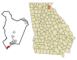
Location in Habersham County and the state of Georgia
|
|
| Country | United States |
| State | Georgia |
| County | Habersham |
| Area | |
| • Total | 2.01 sq mi (5.21 km2) |
| • Land | 2.00 sq mi (5.19 km2) |
| • Water | 0.01 sq mi (0.02 km2) |
| Elevation | 1,394 ft (425 m) |
| Population
(2020)
|
|
| • Total | 2,803 |
| • Density | 1,398.70/sq mi (539.95/km2) |
| Time zone | UTC-5 (Eastern (EST)) |
| • Summer (DST) | UTC-4 (EDT) |
| ZIP code |
30510
|
| Area code(s) | 706 |
| FIPS code | 13-63588 |
| GNIS feature ID | 2403460 |
Raoul is a small place in Habersham County, Georgia, United States. It is known as an unincorporated community and a census-designated place (CDP). This means it's a group of homes and businesses that isn't officially a city or town, but the government counts its population separately.
In 2010, about 2,558 people lived in Raoul. This number grew from 1,816 people in 2000. By 2020, the population had increased to 2,803.
Contents
Exploring Raoul's Location
Raoul is located in the southwestern part of Habersham County. It shares a border with the town of Alto to the northeast. To the southeast, it borders Banks County.
Two important roads pass near Raoul. Georgia State Route 13 (also called Gainesville Highway) runs along the Banks County line. U.S. Route 23 (Tommy Irwin Parkway) is a four-lane highway that forms the northwest edge of the community.
Raoul is about 6 miles (10 km) northeast of Cornelia. It is also about 18 miles (29 km) southwest of Gainesville.
How Big is Raoul?
The area of Raoul is about 2.0 square miles (5.2 square kilometers). Most of this area is land. Only a very small part, about 0.01 square miles (0.02 square kilometers), is water.
Who Lives in Raoul?
| Historical population | |||
|---|---|---|---|
| Census | Pop. | %± | |
| 2020 | 2,803 | — | |
| U.S. Decennial Census | |||
In 2010, there were 2,558 people living in Raoul. There were 348 households, which are groups of people living together in one home. Out of these, 262 were families.
The population density was about 1,266 people per square mile (489 people per square kilometer). This tells us how many people live in a certain amount of space.
People and Their Backgrounds
The people living in Raoul come from different backgrounds:
- 66.8% were White.
- 24.6% were African American.
- 0.4% were Native American.
- 0.7% were Asian.
- 6.0% were from other races.
- 1.4% were from two or more races.
About 10.2% of the people were Hispanic or Latino.
Households and Families
Many households in Raoul had children under 18 living with them (35.6%). Most households (54.3%) were married couples living together. Some households (14.4%) had a female head of the house with no husband present. About 20.1% of all households were made up of individuals living alone.
The average household had about 2.91 people. The average family had about 3.36 people.
Age Groups
The people in Raoul are spread across different age groups:
- 13.1% were under 20 years old.
- 8.83% were between 20 and 24 years old.
- 49.2% were between 25 and 44 years old.
- 24.5% were between 45 and 64 years old.
- 4.3% were 65 years or older.
The average age of people in Raoul was 36.1 years.
Money and Income
In 2000, the average income for a household in Raoul was about $35,192 per year. For families, the average income was $36,538. The average income per person was $6,871.
About 14.4% of families and 18.7% of all people lived below the poverty line. This included 25.3% of those under 18 and 15.8% of those 65 or older.
Learning in Raoul
All schools in Habersham County are part of the Habersham County School District. This district helps provide education for students living in Raoul.
See also
 In Spanish: Raoul (Georgia) para niños
 | Georgia Louise Harris Brown |
 | Julian Abele |
 | Norma Merrick Sklarek |
 | William Sidney Pittman |

