Ravine des Casoars facts for kids
Quick facts for kids Ravine des Casoars |
|
|---|---|

Ravine des Casoars
|
|
| Length | 3 kilometres (1.9 miles) east–west |
| Area | 96 square kilometres (37 square miles) |
| Depth | 100 metres (330 feet) |
| Geography | |
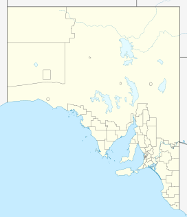
Ravine des Casoars (English: Ravine of the Cassowaries) is a special place on the west coast of Kangaroo Island in South Australia. It's like a deep, narrow valley or gorge. The name means "Ravine of the Cassowaries" in English. It's about 95 kilometers (about 59 miles) west of a town called Kingscote.
Contents
Exploring Ravine des Casoars
The Ravine des Casoars is a valley with very steep sides. It stretches for about 3 kilometers (nearly 2 miles) from east to west. At its deepest, it goes down about 100 meters (about 328 feet). This ravine collects water from a large area of about 96 square kilometers (about 37 square miles) on the western part of Kangaroo Island.
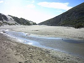
The ravine opens up to the sea on the island's west coast. It forms a gap about 120 meters (about 394 feet) wide in the tall cliffs along the coastline. Inside this gap, there's a sandy beach. This beach and a sand dune behind it stretch about 600 meters (about 1,968 feet) back into the ravine. They reach up to about 100 meters (about 328 feet) high on the south side. On the north side of the ravine, a creek flows into a small lagoon.
Coastal Caves and Wildlife
The base of the cliffs on the northern side of the beach has been worn away by the sea. This has created some interesting caves. In 1965, two caves were described.
One cave, known as 'K5', was about 50 feet (15 meters) wide. At its entrance, there was a home for little penguins. The cave also had a huge rockfall and cool decorations like flowstone, which are mineral deposits that look like frozen waterfalls. A naturalist named Mervinia Masterman also wrote about the penguin rookery in her book Flinder's Chase Revisited (1972).
Next to 'K5' is another cave called 'K16'. This cave was described as being about 400 feet (122 meters) long, 40 feet (12 meters) wide, and 10 feet (3 meters) high. It had beautiful decorations like rimstone (small dams of minerals) and stalactites (icicle-shaped mineral formations hanging from the ceiling).
History of the Ravine
Early Human Presence
Aboriginal sites have been found at Ravine des Casoars by the South Australian Museum. Scientists have used radiocarbon dating on materials found at nearby sites. This method helps them figure out how old things are. The findings suggest that Aboriginal people lived in the western part of Kangaroo Island for a very long time. They were there from about 7,500 years ago until about 350–400 years ago.
European Exploration
The first Europeans known to visit the ravine were part of the Baudin expedition between 1800 and 1803. Baudin, the leader of the expedition, reportedly named the ravine. He saw many birds that he thought were cassowaries, but they were actually the now-extinct Kangaroo Island Emu. That's why he named it "Ravine of the Cassowaries."
People have also reported seeing an old inscription in one of the coastal caves where the ravine meets the sea. This inscription supposedly has Baudin's name and other French names. As of 1999, this inscription had not been found again. It might be hidden by sand or other changes inside the cave.
Protected Status
Today, Ravine des Casoars is part of a special protected area called the Ravine des Casoars Wilderness Protection Area. This means the area is protected to keep its natural beauty and wildlife safe for the future.
 | Tommie Smith |
 | Simone Manuel |
 | Shani Davis |
 | Simone Biles |
 | Alice Coachman |


