Red Rock, Yavapai County, Arizona facts for kids
Quick facts for kids
Red Rock, Arizona
|
|
|---|---|

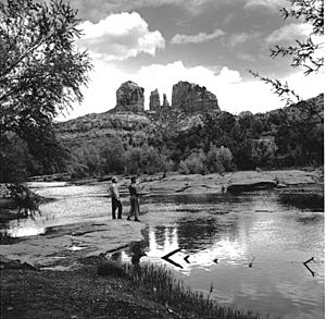
Red Rock Crossing in 1959
|
|
| Country | United States |
| State | Arizona |
| County | Yavapai |
| Elevation | 3,976 ft (1,212 m) |
| Time zone | UTC-7 (Mountain (MST)) |
| Area code(s) | 928 |
| GNIS feature ID | 33497 |
Red Rock is a special place located in Yavapai County, Arizona, in the United States. It's about 4.5 miles (7.2 kilometers) southwest of the well-known town of Sedona.
Contents
Discover Red Rock Crossing
One of the most famous spots in this area is called Red Rock Crossing. This used to be a "ford," which is a shallow place in a river or creek where people and vehicles could cross. Red Rock Crossing allowed people to get across Oak Creek.
This crossing was known for its amazing views of a huge, beautiful rock formation called Cathedral Rock. Imagine seeing that incredible sight every time you crossed the creek!
History of the Crossing
Sadly, in 1978, a big flood washed out the Red Rock Crossing. This means it was damaged so badly that cars can't use it anymore. There are no plans right now to fix it for cars to cross again.
Most of the area around the crossing is now part of the Crescent Moon Ranch recreation area. This area is managed by the Coconino National Forest. It's a great place for people to visit and enjoy nature, even if they can't drive across the creek anymore.
Another Name: Baldwins Crossing
Did you know that Red Rock Crossing also had another name? It was sometimes called Baldwins Crossing. So, if you ever hear that name, you'll know they're talking about the same historic spot!
Images for kids
-
Cathedral Rock at Red Rock Crossing, 2009
 | Bayard Rustin |
 | Jeannette Carter |
 | Jeremiah A. Brown |


