Regans Ford, Western Australia facts for kids
Quick facts for kids Regans FordWestern Australia |
|
|---|---|

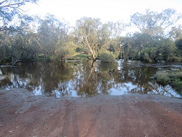
The former Moore River crossing at Regans Ford, now closed, in August 2022
|
|
| Postcode(s) | 6507 |
| Area | [convert: needs a number] |
| Location | |
| LGA(s) | Shire of Dandaragan |
| State electorate(s) | Moore |
| Federal Division(s) | Durack |
Regans Ford is a small town in Western Australia. It is located about 110 kilometers (or 68 miles) north of Perth. This town is part of the Wheatbelt region. It is also located within the Shire of Dandaragan.
The land around Regans Ford is great for farming. Farmers here grow lots of wheat and other cereal crops. The town has a special place called a "grain receival point." This is where farmers bring their crops to be collected by a company called Cooperative Bulk Handling (CBH).
Contents
The Story Behind Regans Ford
Regans Ford gets its name from a special crossing point. This crossing is called a ford, and it goes over the Moore River. Maps have shown this ford since at least the year 1880.
Who Was Edward Regan?
The ford itself was named after a man called Edward Regan. He was a shepherd in the area during the 1860s. Later, in the 1870s, Edward Regan bought land close to this river crossing. Some stories say that Regan was hired to build the crossing. He worked with Aboriginal people to create it.
A Place for Travelers
In 1880, the land next to the ford was set aside. It became a watering place for people traveling and for their animals. This helped travelers and their livestock on their long journeys.
Becoming a Townsite
Much later, in 1968, people were planning a new road. This road would connect Gingin to Eneabba. During this planning, someone suggested that the land at Regans Ford could be used for a new town.
 | Laphonza Butler |
 | Daisy Bates |
 | Elizabeth Piper Ensley |


