
Lancelin, Western Australia facts for kids
Quick facts for kids LancelinWestern Australia |
|
|---|---|

View of the Indian Ocean, south of the Lancelin pier.
|
|

Lancelin
Location in Western Australia
|
|
| Postcode(s) | 6044 |
| Elevation | 6 m (20 ft) |
| Area | [convert: needs a number] |
| Location |
|
| LGA(s) | Shire of Gingin |
| State electorate(s) | Moore |
| Federal Division(s) | Pearce |
Lancelin is a small, fun town for fishing and holidays in Western Australia. It's about 127 kilometers (79 miles) north of Perth. You can find it at the end of Lancelin Road, not far from the beautiful Indian Ocean Drive.
Lancelin is also near where a famous ship, the Vergulde Draeck (or Gilt Dragon), sank in 1656. It hit rocks close to the shore. Usually, about 600 people live in Lancelin. But during holidays like Christmas and New Year, the town gets super busy with up to 2,500 visitors!
Contents
History of Lancelin
How Lancelin Got Its Name
The town of Lancelin is named after Lancelin Island, which is nearby. This island was named by Captain Nicolas Baudin in 1801. He was a French explorer, and he named it after P.J. Lancelin, who was a writer about science.
Early Days and Fishing
Back in the 1940s, Lancelin was mostly a place where people went camping for holidays. Some small holiday shacks were probably built around this time. People started to become more interested in the area because it was a good spot for crayfish (also called lobsters) fishing. One famous fishing boat used here in the 1960s was the Trixen. You can now see this boat at the Western Australian Maritime Museum.
Becoming a Town
Lancelin officially became a town in 1950. It was first called "Wangaree," which is an Aboriginal word meaning "fish." But in 1953, the local government asked for the name to be changed, and so it became Lancelin.
Cool Science and Training
In 1974, something exciting happened in Lancelin. Two special rockets were launched from here to study the sun during a solar eclipse. This was part of scientific research! Also, the Australian military has used the Lancelin Defence Training Area north of the town for training exercises since the 1940s.
Fun Things to Do in Lancelin
Islands and Wildlife
Just off the coast of Lancelin, there are two islands: Edwards Island and Lancelin Island.
Lancelin Island is a special nature reserve about 500 meters (1,640 feet) from the shore. It's protected to help keep its plants and animals safe. Many different seabirds nest here, and you can also find landbirds, lizards, and even resting sea lions. You can visit this island by boat, and it's a popular trip in summer. There's a walkway on the island where you can walk and watch the amazing wildlife.
Edwards Island is a very important nature reserve, so people are not allowed to visit it.
Awesome Outdoor Activities
Lancelin is a fantastic place for water sports! Kitesurfing and windsurfing are very popular in the ocean here. If you prefer land adventures, you can try sandboarding down the huge sand dunes. Riding on a dune buggy, motorbike, or four-wheel drive on the beaches and dunes behind the town is also a lot of fun.
Events and Records
Every March, there's a fun "colour blast" event held right on the beach. It's a colorful and exciting time! The Lancelin District Community Association even holds a Guinness World Record for the largest off-road vehicle convoy. That's a lot of cars driving together!
Lancelin's Climate
Lancelin has a hot-summer mediterranean climate. This means it's usually warm all year round, a bit like a subtropical climate, but with very dry summers.
| Climate data for Lancelin | |||||||||||||
|---|---|---|---|---|---|---|---|---|---|---|---|---|---|
| Month | Jan | Feb | Mar | Apr | May | Jun | Jul | Aug | Sep | Oct | Nov | Dec | Year |
| Record high °C (°F) | 46.0 (114.8) |
45.3 (113.5) |
43.6 (110.5) |
37.5 (99.5) |
32.0 (89.6) |
29.4 (84.9) |
27.7 (81.9) |
29.0 (84.2) |
32.4 (90.3) |
39.0 (102.2) |
40.7 (105.3) |
43.2 (109.8) |
46.0 (114.8) |
| Mean daily maximum °C (°F) | 29.2 (84.6) |
30.0 (86.0) |
28.5 (83.3) |
25.5 (77.9) |
22.7 (72.9) |
20.2 (68.4) |
19.2 (66.6) |
19.3 (66.7) |
20.5 (68.9) |
22.5 (72.5) |
24.9 (76.8) |
27.3 (81.1) |
24.2 (75.6) |
| Mean daily minimum °C (°F) | 17.6 (63.7) |
18.1 (64.6) |
16.7 (62.1) |
14.6 (58.3) |
12.4 (54.3) |
10.8 (51.4) |
9.9 (49.8) |
9.9 (49.8) |
10.5 (50.9) |
11.9 (53.4) |
14.1 (57.4) |
16.2 (61.2) |
13.6 (56.5) |
| Record low °C (°F) | 8.6 (47.5) |
8.3 (46.9) |
6.3 (43.3) |
4.4 (39.9) |
3.3 (37.9) |
1.6 (34.9) |
1.5 (34.7) |
0.1 (32.2) |
1.0 (33.8) |
3.2 (37.8) |
4.4 (39.9) |
4.4 (39.9) |
0.1 (32.2) |
| Average precipitation mm (inches) | 8.9 (0.35) |
12.0 (0.47) |
14.1 (0.56) |
30.8 (1.21) |
82.6 (3.25) |
119.5 (4.70) |
120.7 (4.75) |
91.1 (3.59) |
56.4 (2.22) |
28.9 (1.14) |
20.9 (0.82) |
8.2 (0.32) |
592.3 (23.32) |
| Average precipitation days | 2.0 | 2.1 | 3.5 | 7.0 | 12.0 | 15.4 | 16.6 | 15.4 | 12.6 | 8.2 | 5.4 | 3.0 | 103.2 |
| Average relative humidity (%) | 61 | 60 | 60 | 62 | 61 | 63 | 65 | 64 | 64 | 62 | 62 | 61 | 62 |
Gallery
-
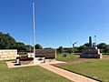
Lancelin War Memorial
-
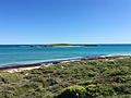
Lancelin Island viewed from the lookout
-
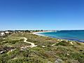
View from Lancelin Lookout southward towards the town centre and the jetty
-
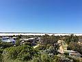
Sand dunes to the northeast of Lancelin viewed from the lookout
-
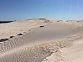
Lancelin sand dunes


