
Rheinwald, Switzerland facts for kids
Quick facts for kids
Rheinwald
|
||
|---|---|---|
 |
||
|
||

Rheinwald
Location in Switzerland

Rheinwald
Location in Canton of Graubünden
|
||
| Country | Switzerland | |
| Canton | Graubünden | |
| District | Viamala | |
| Area | ||
| • Total | 136.82 km2 (52.83 sq mi) | |
| Population
(Dec 2020 )
|
||
| • Total | 574 | |
| • Density | 4.195/km2 (10.866/sq mi) | |
| Postal code |
7435,37,38
|
|
| Surrounded by | Blenio (TI), Malvaglia (TI), Mesocco, Vals | |

Rheinwald is a cool place in Switzerland, located in the Viamala Region in the Graubünden area. It's a 'municipality,' which is like a local government area. It was created on January 1, 2019, when three smaller towns – Hinterrhein, Nufenen, and Splügen – decided to join together to form one bigger community.
Contents
History of Rheinwald Towns
The area that is now Rheinwald has a long history. Each of the towns that joined together has its own story.
Hinterrhein's Early Days
The town of Hinterrhein was first written about in documents way back in 1219. It was called de Reno then, showing how old it is!
Nufenen Through Time
Nufenen was first mentioned in 1343, known as Ovena. Later, in 1633, it was called Nufena. People who spoke Romansh called it Nueinas, and in Italian, it used to be known as Novena.
Splügen's Ancient Roots
Splügen is even older! It was first mentioned around the year 840. Back then, it was called cella in Speluca, which means a small church or settlement in a cave-like area.
Rheinwald's Geography
After the towns merged, Rheinwald became a larger area. As of 2009, it covers about 136.82 km2 (52.83 sq mi) of land. That's a pretty big space for exploring!
Rheinwald's Population
The new municipality of Rheinwald has a total population of 574 people as of December 2020.
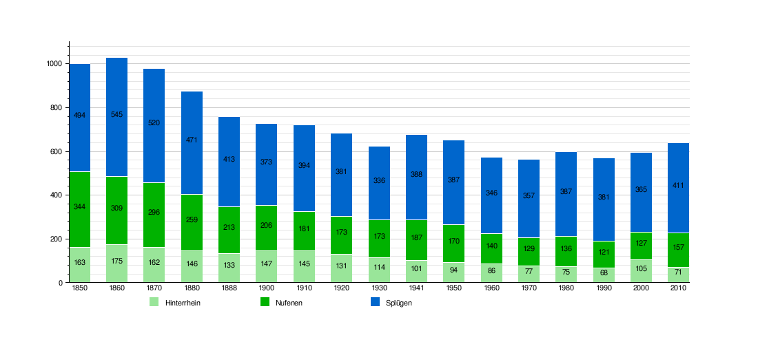
How the Population Changed Over Time
It's interesting to see how the number of people living in these towns has changed over many years. The chart below shows the historical population for Hinterrhein, Nufenen, and Splügen before they merged. You can see how each town's population went up and down.
Important Heritage Sites
Rheinwald is home to some really important historical buildings. These are so special that they are listed as heritage sites of national significance.
- The Alte Landbrücke (which means Old Bridge)
- The Säumerherberge (a hostel for mule drivers) called Weiss Kreuz
These places help us remember the past and how people lived and traveled long ago.

Splügen's Wakker Prize
In 1995, the village of Splügen (one of the towns that formed Rheinwald) won a special award called the Wakker Prize. This prize is given by the Swiss Heritage Society. They gave it to Splügen because the village did a great job of keeping its old, historic look while also allowing new buildings and tourism to grow. They found a good balance between protecting the past and planning for the future. The old part of town was kept safe to look just as it always had, while new developments were built carefully outside the historic center.
Rheinwald's Climate
The climate in Rheinwald, especially around Hinterrhein, can be quite interesting. Between 1961 and 1990, Hinterrhein had about 121.4 days of rain each year. On average, it received about 1,469 mm (57.8 in) of precipitation (rain or snow).
The wettest month was usually May, with about 194 mm (7.6 in) of precipitation over 14.2 days. The driest month was February, with only about 45 mm (1.8 in) of precipitation.
Detailed Weather Information
Here's a closer look at the weather in Hinterrhein from 1981 to 2010:
| Climate data for Hinterrhein (1981-2010) | |||||||||||||
|---|---|---|---|---|---|---|---|---|---|---|---|---|---|
| Month | Jan | Feb | Mar | Apr | May | Jun | Jul | Aug | Sep | Oct | Nov | Dec | Year |
| Mean daily maximum °C (°F) | −1.5 (29.3) |
−0.6 (30.9) |
2.6 (36.7) |
5.6 (42.1) |
11.2 (52.2) |
15.3 (59.5) |
18.1 (64.6) |
17.5 (63.5) |
13.6 (56.5) |
9.6 (49.3) |
3.0 (37.4) |
−0.8 (30.6) |
7.8 (46.0) |
| Daily mean °C (°F) | −6.3 (20.7) |
−5.8 (21.6) |
−2.1 (28.2) |
1.6 (34.9) |
6.5 (43.7) |
10.0 (50.0) |
12.5 (54.5) |
12.0 (53.6) |
8.5 (47.3) |
4.6 (40.3) |
−1.2 (29.8) |
−5.0 (23.0) |
2.9 (37.2) |
| Mean daily minimum °C (°F) | −11.6 (11.1) |
−11.9 (10.6) |
−7.4 (18.7) |
−2.7 (27.1) |
1.8 (35.2) |
4.3 (39.7) |
6.4 (43.5) |
6.5 (43.7) |
3.5 (38.3) |
0.1 (32.2) |
−5.3 (22.5) |
−9.6 (14.7) |
−2.2 (28.0) |
| Average precipitation mm (inches) | 50 (2.0) |
37 (1.5) |
65 (2.6) |
137 (5.4) |
197 (7.8) |
175 (6.9) |
171 (6.7) |
184 (7.2) |
186 (7.3) |
179 (7.0) |
150 (5.9) |
67 (2.6) |
1,598 (62.9) |
| Average snowfall cm (inches) | 80.1 (31.5) |
63 (25) |
71.4 (28.1) |
66.5 (26.2) |
13.2 (5.2) |
8.6 (3.4) |
0.2 (0.1) |
1.1 (0.4) |
3.7 (1.5) |
17.8 (7.0) |
42.7 (16.8) |
68.8 (27.1) |
437.1 (172.1) |
| Average precipitation days (≥ 1.0 mm) | 6.7 | 5.6 | 7.2 | 10.1 | 13.0 | 12.4 | 11.8 | 12.2 | 9.4 | 9.7 | 8.8 | 7.2 | 114.1 |
| Average snowy days (≥ 1.0 cm) | 8.9 | 8.4 | 8.1 | 7.1 | 2.1 | 0.8 | 0.1 | 0.2 | 0.5 | 1.8 | 5.8 | 9 | 52.8 |
| Average relative humidity (%) | 73 | 72 | 72 | 73 | 73 | 73 | 73 | 76 | 77 | 76 | 76 | 75 | 74 |
| Mean monthly sunshine hours | 59 | 94 | 117 | 112 | 149 | 166 | 193 | 174 | 128 | 103 | 58 | 39 | 1,391 |
| Source: MeteoSwiss | |||||||||||||
