
Riberalta facts for kids
Quick facts for kids
Riberalta
|
|
|---|---|
|
Town and municipality
|
|

Riberalta, Bolivia
|
|

Riberalta
Location in Bolivia
|
|
| Country | |
| Department | Beni Department |
| Province | Vaca Díez Province |
| Settled | 1897 |
| Area | |
| • Total | 20.1 km2 (7.8 sq mi) |
| Elevation | 144 m (472 ft) |
| Population
(2018)
|
|
| • Total | 99,070 |
| • Density | 4,929/km2 (12,770/sq mi) |
| Time zone | UTC-4 (BOT) |
| Area code(s) | +591 2 |
| Website | Official website: http://www.bolivia-riberalta.com/ |
Riberalta is a town in northern Bolivia. It is located in the Beni Department, where the Madre de Dios River meets the Beni River. Riberalta sits on the southeast bank of the Beni River.
This city is the capital of the Vaca Diez Province. It is known for its natural beauty, thanks to its location near the Beni and Madre de Dios rivers. It is also close to the amazing Amazon rainforest. Riberalta is often called the "Bolivian capital of the Amazon." It is also home to a part of the Bolivian Navy.
Riberalta is very important for the trade of Brazil nuts. Bolivia produces most of the world's Brazil nuts. In 2017/2018, Bolivia made 78% of all Brazil nuts! Peru made 16%, and Brazil made only 2%.
Contents
History of Riberalta
Who Lived in Riberalta First?
The area where Riberalta is now was first home to native people like the Chácobo and Pacahuara. They called this place "Pamahuayá," which means "place of the fruits."
A Bolivian expert named Wigberto Rivero found that other native groups also lived here. These groups, like the Pacahuara, Chacobos, Caripunas, Sinabos, and Perintintin, spoke languages from the Pano family. They lived here for thousands of years. They even fought against attacks from the Incan Empire and later settlers from the west.
How Riberalta Got Its Name
The name Riberalta comes from two Spanish words: "ribera alta." This means "high bank" in English. The city was officially started on February 3, 1894. About 2,500 people lived there at that time. It was built in a red canyon in northern Bolivia.
Riberalta has had four different names over time:
- Barranca Colorada (Red Canyon)
- La Cruz (The Cross)
- Ribera-Alta (High Bank)
- Riberalta
In the mid-1800s, explorers went into the jungle of northwest Bolivia. They found high riverbanks, more than thirty meters tall. Two large rivers met there, which helped the area become an important economic center.
On October 8, 1880, a man named Don Edwin Heath called the city Barranca Colorada. A few years later, a German manager named Frederico Bodo Claussen heard about the place. He sent someone to set up a business there.
Then, on May 3, 1884, it was named La Cruz. This happened when Don Maximo Henicke looked at a small house built two years earlier. Just over a year later, on July 7, 1885, Bodo Claussen gave it the name Ribera-Alta. This name was later combined to become Riberalta.
Finally, on February 3, 1894, Riberalta was officially founded as Villa Riberalta. This was done by Lysimachus Gutiérrez, who was a National Delegate of the Colonies. He acted under the orders of President Mariano Baptista. The founding also honored the birthday of Mcal. Antonio Jose de Sucre.
Climate in Riberalta
Riberalta is in a special climate zone. It's between the tropical savanna climate of the Llanos de Moxos and the tropical monsoon climate of the Amazon rainforest. This means it has a wet season and a dry season.
The city gets a good amount of rain, but it's very different depending on the time of year. According to the Köppen Climate Classification system, Riberalta has a "tropical savanna climate," also known as "Aw."
| Climate data for Riberalta, elevation 141 m (463 ft) | |||||||||||||
|---|---|---|---|---|---|---|---|---|---|---|---|---|---|
| Month | Jan | Feb | Mar | Apr | May | Jun | Jul | Aug | Sep | Oct | Nov | Dec | Year |
| Record high °C (°F) | 35.0 (95.0) |
35.0 (95.0) |
36.0 (96.8) |
34.6 (94.3) |
35.8 (96.4) |
33.3 (91.9) |
34.2 (93.6) |
36.4 (97.5) |
38.3 (100.9) |
36.5 (97.7) |
36.0 (96.8) |
36.8 (98.2) |
38.3 (100.9) |
| Mean daily maximum °C (°F) | 31.5 (88.7) |
31.4 (88.5) |
31.7 (89.1) |
31.7 (89.1) |
31.2 (88.2) |
31.0 (87.8) |
31.7 (89.1) |
33.1 (91.6) |
33.6 (92.5) |
33.4 (92.1) |
32.4 (90.3) |
31.7 (89.1) |
32.0 (89.7) |
| Daily mean °C (°F) | 26.8 (80.2) |
26.7 (80.1) |
26.8 (80.2) |
26.6 (79.9) |
25.7 (78.3) |
24.8 (76.6) |
24.6 (76.3) |
25.8 (78.4) |
26.9 (80.4) |
27.4 (81.3) |
27.1 (80.8) |
26.9 (80.4) |
26.3 (79.4) |
| Mean daily minimum °C (°F) | 22.1 (71.8) |
22.0 (71.6) |
21.9 (71.4) |
21.5 (70.7) |
20.2 (68.4) |
18.6 (65.5) |
17.4 (63.3) |
18.5 (65.3) |
20.2 (68.4) |
21.5 (70.7) |
21.8 (71.2) |
22.0 (71.6) |
20.6 (69.2) |
| Record low °C (°F) | 20.6 (69.1) |
20.0 (68.0) |
17.2 (63.0) |
15.0 (59.0) |
10.0 (50.0) |
9.9 (49.8) |
8.9 (48.0) |
10.0 (50.0) |
13.8 (56.8) |
16.1 (61.0) |
16.0 (60.8) |
19.0 (66.2) |
8.9 (48.0) |
| Average precipitation mm (inches) | 279.2 (10.99) |
265.7 (10.46) |
256.2 (10.09) |
157.3 (6.19) |
74.7 (2.94) |
27.3 (1.07) |
17.2 (0.68) |
21.8 (0.86) |
64.5 (2.54) |
144.8 (5.70) |
201.4 (7.93) |
262.4 (10.33) |
1,772.5 (69.78) |
| Average precipitation days | 17.6 | 16.4 | 15.9 | 11.4 | 6.6 | 3.0 | 1.4 | 2.0 | 4.7 | 9.4 | 12.8 | 16.2 | 117.4 |
| Average relative humidity (%) | 80.9 | 81.7 | 80.9 | 80.6 | 78.7 | 76.1 | 69.5 | 66.2 | 67.7 | 72.4 | 77.0 | 79.6 | 75.9 |
| Source 1: Servicio Nacional de Meteorología e Hidrología de Bolivia | |||||||||||||
| Source 2: Deutscher Wetterdienst (extremes) | |||||||||||||
Getting Around Riberalta
Riberalta is connected to the city of Cobija by bus. You can also reach the rest of Bolivia by flying from the Capitán Av. Selin Zeitun Lopez Airport (RIB). This airport serves northern Bolivia.
Images for kids
-
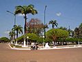
Main square of the city, Riberalta, Bolivia
-
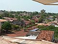
A view of the city


See also
 In Spanish: Riberalta para niños
