Richmond West, Florida facts for kids
Quick facts for kids
Richmond West, Florida
|
|
|---|---|

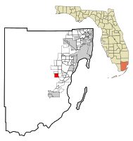
Location in Miami-Dade County and the state of Florida
|
|

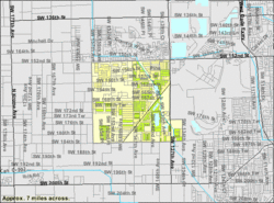
U.S. Census Bureau map showing CDP boundaries
|
|
| Country | |
| State | |
| County | |
| Area | |
| • Total | 4.28 sq mi (11.09 km2) |
| • Land | 4.17 sq mi (10.80 km2) |
| • Water | 0.11 sq mi (0.29 km2) |
| Elevation | 7 ft (2 m) |
| Population
(2020)
|
|
| • Total | 35,884 |
| • Density | 8,601.15/sq mi (3,321.09/km2) |
| Time zone | UTC-5 (Eastern (EST)) |
| • Summer (DST) | UTC-4 (EDT) |
| ZIP Codes |
33177, 33187 (Miami)
|
| Area code(s) | 305, 786, 645 |
| FIPS code | 12-60230 |
| GNIS feature ID | 1853280 |
Richmond West is a special kind of community in Miami-Dade County, Florida, United States. It's called a census-designated place (CDP). This means it's an area that looks like a town or city but doesn't have its own official city government. Instead, it's managed by the county.
Richmond West is part of the larger Miami metropolitan area in South Florida. In 2020, about 35,884 people lived there. This was an increase from 31,973 people in 2010.
Contents
History of Richmond West
Richmond West started as a small settlement in the early 1900s. It was first known as Eureka.
In 1907, a simple one-room schoolhouse was built in Eureka. It was located at the corner of S.W. 147th Avenue and S.W. 184th Street. This school closed in 1916. Its students, along with those from six other local one-room schools, moved to the bigger Redland Farm Life School. This new school was about four miles south.
By 1927, the area was known as Richmond. The Seaboard Air Line Railway built a train station here. Even though the old station is gone, the train tracks are still used today by CSX, which is the company that took over from Seaboard.
Major Storms and Rebuilding
In 1945, a very strong storm called the 1945 Homestead hurricane hit the area. It caused a lot of damage, estimated at $50,000,000. Almost half of this damage happened at the nearby Naval Air Station Richmond. Strong winds started a fire there. The fire destroyed 25 blimps, 366 planes, and 150 cars.

For many years, Richmond West was mostly farmland. But in the mid-1980s, new neighborhoods and the Dadeland Mobile Home Park were built. These were located south of S.W. 152nd Street.
In August 1992, another very powerful storm, Hurricane Andrew, struck the area. It completely destroyed the mobile home park. Many homes and businesses in the surrounding area were also ruined. After the hurricane, people worked hard to rebuild. New homes and businesses were gradually built, and development continued southward.
Where is Richmond West?
Richmond West is located about 21 miles southwest of downtown Miami. You can find it at the coordinates 25.610164 degrees North and 80.427836 degrees West.
To the north of Richmond West is a community called Country Walk. Part of Zoo Miami is also located just to the east of Richmond West.
The United States Census Bureau says that Richmond West covers a total area of about 4.3 square miles (11.09 square kilometers). Most of this area, about 4.2 square miles (10.80 square kilometers), is land. The rest, about 0.1 square miles (0.29 square kilometers), is water.
Population of Richmond West
The number of people living in Richmond West has grown a lot over the years.
- In 1990, there were 8,583 people.
- By 2000, the population grew to 28,082 people.
- In 2010, there were 31,973 people.
- And in 2020, the population reached 35,884 people.
This shows that more and more families are choosing to live in Richmond West. In 2020, there were 10,103 households and 8,837 families living in this community.
See also
 In Spanish: Richmond West para niños
 | Valerie Thomas |
 | Frederick McKinley Jones |
 | George Edward Alcorn Jr. |
 | Thomas Mensah |

