Ridgefield (CDP), Connecticut facts for kids
Quick facts for kids
Ridgefield, Connecticut
|
|
|---|---|

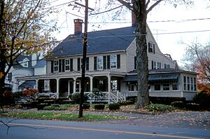
Elms Tavern, built in 1799
|
|

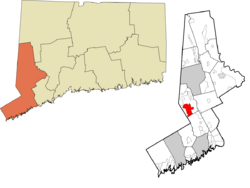
Location within the Western Connecticut Planning Region and the state of Connecticut
|
|
| State | Connecticut |
| County | Fairfield |
| Town | Ridgefield |
| Area | |
| • Total | 6.40 sq mi (16.58 km2) |
| • Land | 6.40 sq mi (16.57 km2) |
| • Water | 0.008 sq mi (0.02 km2) |
| Elevation | 749 ft (228 m) |
| Population
(2010)
|
|
| • Total | 7,645 |
| • Density | 1,195/sq mi (461.5/km2) |
| ZIP Code |
06877
|
| FIPS code | 09-63900 |
| GNIS feature ID | 2377856 |
Ridgefield is a special kind of community called a census-designated place (CDP) in Fairfield County, Connecticut, USA. It's like the main village area within the larger town of Ridgefield, plus the homes around it. In 2020, about 7,596 people lived in this CDP part of Ridgefield. The whole town of Ridgefield had about 25,053 people.
Contents
Geography of Ridgefield
This community is located in the southern part of the larger town of Ridgefield.
Main Roads in Ridgefield
Several important roads pass through Ridgefield, making it easy to get around:
- Connecticut Route 33 is known as Ridgefield's Main Street.
- Connecticut Route 35 also runs through the area.
- Connecticut Route 102, called Branchville Road, goes east from Main Street.
- Connecticut Route 116, or North Salem Road, heads northwest from the north end of Main Street.
Land and Water Area
The Ridgefield CDP covers about 16.6 square kilometers (about 6.4 square miles). Most of this area is land. Only a tiny part, about 0.02 square kilometers (0.008 square miles), is water.
People of Ridgefield (Demographics)
Let's look at who lives in Ridgefield and how the population is made up.
Population Count
In 2010, there were 7,645 people living in the Ridgefield CDP. These people lived in 3,046 homes, and 2,018 of those were families. On average, there were about 2.5 people in each home and 3.17 people in each family.
Diversity in Ridgefield
The people living in Ridgefield come from different backgrounds:
- About 93.6% were White.
- Around 3.0% were Asian.
- About 1.0% were African American.
- A small number were Native American, Alaska Native, or Pacific Islander.
- About 1.5% were from two or more races.
- People of Hispanic or Latino background made up 4.2% of the population.
Age Groups in Ridgefield
The community has people of all ages:
- About 27.8% of the population were under 18 years old.
- Around 15.4% were 65 years old or older.
- The average age in Ridgefield was about 43.5 years old.
Household Income
From 2013 to 2017, the estimated average yearly income for a household in Ridgefield was about $125,595. For families, the average income was higher, around $165,333. The income per person was about $74,017. A small number of families (0.9%) and people (2.5%) lived below the poverty line.
See also
 In Spanish: Ridgefield (condado de Fairfield) para niños
 | Delilah Pierce |
 | Gordon Parks |
 | Augusta Savage |
 | Charles Ethan Porter |

