
Riemst facts for kids
Quick facts for kids
Riemst
|
|||
|---|---|---|---|
 |
|||
|
|||

Riemst
Location in Belgium
|
|||
| Country | Belgium | ||
| Community | Flemish Community | ||
| Region | Flemish Region | ||
| Province | Limburg | ||
| Arrondissement | Tongeren | ||
| Area | |||
| • Total | 57.88 km2 (22.35 sq mi) | ||
| Population
(2018-01-01)Lua error in Module:Wd at line 1575: attempt to index field 'wikibase' (a nil value).
|
|||
| • Total | Lua error in Module:Wd at line 1,575: attempt to index field 'wikibase' (a nil value). | ||
| Postal codes |
3770
|
||
| Area codes | 012 | ||
| Website | www.riemst.be | ||


Riemst is a small town in Belgium. It is located in the Limburg province. People in Riemst speak Flemish, which is a type of Dutch.
In 2018, about 16,665 people lived in Riemst. The town covers an area of almost 58 square kilometers. This means about 276 people live in each square kilometer.
Riemst was once the location of an important battle. This was the Battle of Lauffeld, fought in 1747. A bridge in Vroenhoven, a part of Riemst, played a role at the start of World War II. German forces attacked this area.
Before Riemst became the town it is today, Paul Schiepers was the last mayor of its original borough. He was born in 1919 and passed away in 1978.
Areas of Riemst
Riemst is made up of several smaller areas. These areas are:
- Genoelselderen
- Herderen
- Kanne
- Membruggen
- Millen
- Riemst (the main part)
- Val-Meer
- Lafelt
- Vlijtingen
- Vroenhoven
- Heukelom
- Zichen-Zussen-Bolder
Images for kids
-
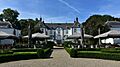
Elderen (wine) castle at Genoelselderen
-
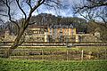
Neercanne castle at Kanne
-
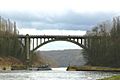
Bridge over the Albert Canal near Vroenhoven
-
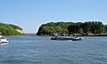
Albert Canal near Kanne


See also
 In Spanish: Riemst para niños
