
Two Guns, Arizona facts for kids
Quick facts for kids
Two Guns, Arizona
|
|
|---|---|
|
Ghost town
|
|

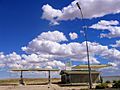
Abandoned gas station in Two Guns
|
|

Two Guns, Arizona
Location in Arizona

Two Guns, Arizona
Location in the United States
|
|
| Country | United States |
| State | Arizona |
| County | Coconino |
| Elevation | 5,423 ft (1,653 m) |
| Population | 0 |
| Time zone | UTC-7 (MST) |
| GNIS feature ID | 24665 |
Two Guns is a fascinating ghost town located in Coconino County, Arizona, United States. It sits on the east edge of Canyon Diablo, about 30 miles (48 km) east of Flagstaff. Two Guns used to be a busy stop for tourists traveling along the famous Route 66. Today, it's a quiet place with many old buildings and stories from the past.
Contents
Exploring Two Guns: A Ghost Town's Story
Early Days and Ancient History
People have lived in the Two Guns area for a very long time. Scientists have found old tools and items from Native Americans that date back to between 1050 and 1600. This shows that the area was important to people centuries ago.
As new settlers arrived in the mid-1800s, they quickly saw that Two Guns was a great spot to cross Canyon Diablo. At first, people crossed by wagon, and later by cars.
The Canyon Diablo Cave Story
In 1878, a significant event happened at a cave in Two Guns. Some Apaches were hiding there from their Navajo enemies. The Navajos found them and lit fires at the cave's entrance. This caused smoke to fill the cave. Sadly, 42 Apaches died from the smoke. Their valuables were taken. This place is now known as the "death cave" because of this sad event.
Outlaws and Hidden Treasure
During the winter of 1879–80, a famous outlaw named Billy the Kid and his gang hid near Two Guns. They stayed in the ruins of a stone house and corral on the west side of Canyon Diablo.
In 1880, before Two Guns became a town, the Santa Fe Railway was building its tracks across northern Arizona. They had to stop near Two Guns to build a bridge over Canyon Diablo. A temporary settlement grew there for the workers. This place became known as Canyon Diablo. It was a very rough and wild place.
In 1889, some men from the Hashknife Ranch robbed a train at Canyon Diablo. They got away with a lot of money and valuables. A group of lawmen, led by Sheriff Buckey O'Neill, chased them. They caught the bandits but found only a small amount of the stolen goods. Years later, one of the thieves said that the rest of the stolen treasure was buried near Two Guns. This makes the area popular with people who love to hunt for treasure!
Building Roads and Bridges
The National Old Trails Highway was built in Arizona in 1907. It generally followed the railway line. This highway crossed the dry riverbed of Canyon Diablo right at the Two Guns location. Cars had to zig-zag up and down the canyon sides.
In 1915, the Canyon Diablo Bridge opened at Two Guns. This made crossing the canyon much easier. This bridge was used until 1938 when a newer bridge was built nearby.
Two Guns Becomes a Tourist Stop
.jpg)


The first person to settle at Two Guns was Ed Randolph. He built a store right next to the death cave.
In 1922, Earle and Louise Cundiff bought 320 acres (130 ha) of land from Randolph. They paid $1,000 for it. They built a store, a restaurant, and gas pumps for travelers.
In 1925, a man named Harry E. Miller leased land from the Cundiffs. He called himself "Chief Crazy Thunder." Miller wanted to attract tourists by showing off the beauty of Canyon Diablo. He built a small zoo along the canyon rim. His zoo had animals like mountain lions, cougars, and snakes. He also opened a restaurant and a gift shop selling Native American items. Miller even cleaned out the death cave and sold Apache skulls as souvenirs.
Miller offered tours to visitors. The tour started at a Hopi house he built, where visitors could see piki bread being made. Then, a paved path led down to a soft drink stand at the bottom of the canyon. Next was a tour of the death cave, where Miller had put electric lights and fake ruins. Miller put up big, colorful signs along the highway. He named his place "Fort Two Guns" after a silent movie actor, William S. "Two Guns" Hart.
In 1925, "Rimmy" Jim Giddings also opened a gas station and cafe called Rimmy Jim's at Two Guns.
In 1926, the highway became known as U.S. Route 66. That same year, there was a disagreement between Cundiff and Miller. Miller shot Cundiff, but he was later found not guilty. Miller's store burned down in 1929. Soon after, Louise Cundiff built her own tourist store. Miller left Arizona the next year. Louise remarried, and in 1934, she opened the Two Guns Texaco service station. They also moved the zoo behind the station, but it closed before 1950.
In 1938, a new bridge was built across Canyon Diablo. Route 66 then followed Interstate 40 through Two Guns. A more modern service station was built in 1963. In the late 1960s, a motel, a western tavern, a reptile exhibit, and a new zoo were added. Later, a Shell service station and a KOA campground also opened.
The Decline of Two Guns
The service station at Two Guns burned down in 1971. After this, Two Guns began to decline. Today, you can still see the ruins of many old buildings. These include the trading post, the campground, old cottages, the zoo, and the burned-out service station. In 1988, the Canyon Diablo Bridge was added to the National Register of Historic Places.
Images for kids
-
Abandoned gas station in Two Guns
