Rindge Tract facts for kids

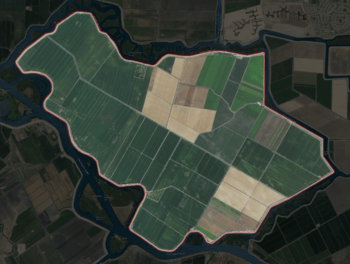
USGS aerial imagery of the Rindge Tract
|
|
| Geography | |
|---|---|
| Location | Northern California |
| Coordinates | 38°01′20″N 121°26′05″W / 38.02222°N 121.43472°W |
| Adjacent bodies of water | Sacramento–San Joaquin River Delta |
| Highest elevation | -3 ft (-0.91 m) |
| Administration | |
|
United States
|
|
| State | |
| County | San Joaquin |
The Rindge Tract is an island located in the Sacramento–San Joaquin River Delta in California. It's part of San Joaquin County. This island is managed by a group called Reclamation District 2037, which helps keep the land safe and usable.
The Rindge Tract is found at these coordinates: 38°01′20″N 121°26′05″W / 38.02222°N 121.43472°W. In 1981, the United States Geological Survey (USGS) measured its elevation. They found that the island is actually −3 ft (−0.91 m) below sea level. This means it's lower than the ocean!
Contents
What is the Sacramento-San Joaquin River Delta?
The Sacramento–San Joaquin River Delta is a huge area where the Sacramento and San Joaquin rivers meet. It's a mix of rivers, canals, and islands. This delta is very important for California's water supply. It provides drinking water for millions of people. It also helps with farming and supports many kinds of wildlife.
How are Delta Islands Formed?
Many islands in the Delta, like Rindge Tract, were once marshy wetlands. Over time, people built levees (special walls) around these areas. This helped to drain the water and create farmland. These islands are often below sea level, making the levees very important.
Why are Delta Islands Important?
Delta islands are important for several reasons. They are used for farming, growing crops like corn, alfalfa, and asparagus. They also provide homes for animals and plants. The Delta is a key stop for many birds migrating along the Pacific Flyway.
How is Rindge Tract Managed?
The Rindge Tract is managed by Reclamation District 2037. A reclamation district is a local government agency. Its main job is to manage water and protect land from floods. They maintain the levees around the island. This keeps the water out and the land dry for use.
What is a Reclamation District?
A reclamation district collects money from landowners to pay for water projects. These projects include building and fixing levees. They also manage drainage systems. Their work is vital for keeping low-lying areas like Rindge Tract safe.


