Rio Grande (Paraná River tributary) facts for kids
Quick facts for kids Rio Grande |
|
|---|---|

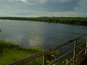
The Rio Grande on the São Paulo/Minas Gerais border in Brazil. Photo taken at the bridge at the end of the Anhanguera Highway.
|
|

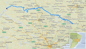
Path of the Rio Grande [1]
|
|
| Country | Brazil |
| State | Minas Gerais, São Paulo |
| Physical characteristics | |
| Main source | Mantiqueira Mountains Minas Gerais, Brazil |
| River mouth | Paraná River confluence with Paranaíba River, Brazil 20°4′41″S 50°59′41″W / 20.07806°S 50.99472°W |
| Length | 1,090 km (680 mi) |
| Basin features | |
| River system | Río de la Plata |
The Rio Grande is a very important river in south-central Brazil. Its name means "great river" in Portuguese. This river starts in the Mantiqueira Mountains in the state of Minas Gerais. From there, it flows towards the west and northwest.
As it continues, part of the Rio Grande forms the border between the states of Minas Gerais and São Paulo. After flowing for about 1,090 kilometers (677 miles), it meets the Paranaíba River. Together, they form the Upper Paraná River, which is a major waterway in South America.
Contents
Rivers Joining the Rio Grande
Many smaller rivers flow into the Rio Grande, adding to its size and power. These are called tributaries.
Major Tributaries
Here are some of the main rivers that join the Rio Grande:
- Rio Aiuruoca: This river starts in Itamonte.
- Rio das Mortes: Its source is located between Barbacena and Senhora dos Remédios.
- Rio Jacaré: This river begins in the Serra do Galba mountains.
- Rio Sapucaí: It starts in the Mantiqueira Mountains in São Paulo.
- Rio Pardo: This river has its source in Ipuiúna.
The Rio Grande Basin
The area of land drained by the Rio Grande and its tributaries is called its basin. This basin is part of the larger Paraná River basin.
Basin Size and Importance
The total area of the Rio Grande basin is about 143,000 square kilometers (55,213 square miles). A large part of this, about 86,500 square kilometers (33,398 square miles), is located within the state of Minas Gerais. This makes up nearly 18% of the state's land. The Rio Grande basin is very important for producing electricity in Minas Gerais. It generates about 67% of all the energy used in the state.
Dams and Power Plants
The Rio Grande has several dams and reservoirs built along its course. These structures are used to control the river's flow and, most importantly, to generate electricity.
Key Dams on the River
Some of the major dams on the Rio Grande include:
- Furnas Dam
- Peixotos Dam
- Luiz Barreto Dam
- Jaguara Dam
- Volta Grande Dam
- Marimbondo Dam
- Água Vermelha Dam
These dams help power homes and businesses across the region.
River Use and History
The Rio Grande is mostly known for producing electricity. Because it has many rapids and waterfalls, and no special water locks, large boats cannot travel easily on it. Only small boats can use certain parts of the river.
Historical River Travel
In the past, from 1889 to 1963, a special narrow gauge railway called the Estrada de Ferro Oeste de Minas (EFOM) offered a unique service. It used steam navigation to carry passengers and freight along the river. The railway met the Rio Grande at Ribeirão Vermelho. From there, boats traveled down the river for about 208 kilometers (129 miles) to Capetina.
There were six stations along the river between Ribeirão Vermelho and Capetinga. The railway company had a fleet of six paddle steamers, along with barges and launches. This river service stopped when the Furnas Dam was completed, as the dam's reservoir covered parts of the old route.
See also
 In Spanish: Río Grande (Minas Gerais) para niños
 | Emma Amos |
 | Edward Mitchell Bannister |
 | Larry D. Alexander |
 | Ernie Barnes |

