
Rio Nido, California facts for kids
Quick facts for kids
Rio Nido, California
Rionido
|
|
|---|---|

Rio Nido, California
Location in California
|
|
| Country | United States |
| State | California |
| County | Sonoma |
| Elevation | 75 ft (23 m) |
| Population
(2010)
|
|
| • Total | 522 |
| Time zone | UTC−8 (PST) |
| • Summer (DST) | UTC−7 (PDT) |
| ZIP Code |
95471
|
| Area code(s) | 707 |
| FIPS code | 06-60956 |
| GNIS feature ID | 1659515 |
Rio Nido, California is a small place in Sonoma County, California. Its name comes from Spanish, meaning "Nest River." It's located on the Russian River, about 1.3 miles (2.1 km) east of Guerneville.
People say the name might have come from an eagle's nest seen on the riverbanks. Rio Nido has two unofficial sayings: "Memories That Linger" and "The Moon Is Always Out In Rio Nido." In 2010, about 522 people lived there.
Life in Rio Nido
Rio Nido is a small community with a post office located inside its fire station. The number of people living here changes with the seasons. In 2000, there were 296 residents, but by 2010, the population grew to 522. Like many resort areas, more people visit or live here during the summer.
This area has many summer homes and cabins. You can also find a few small businesses, like a bar and restaurant, a public pool, and a small resort hotel. Most homes are nestled in a redwood canyon. A small creek, Rio Nido Creek, flows through this canyon into the Russian River. The main roads are named Canyons One, Two, Three, Four, Six, and Seven. There is no Canyon Five.
A Look Back in Time
The land that became Rio Nido was bought in 1908 by the Eagle Lodge in San Francisco. They divided it into smaller pieces for their members. The village was first called "Eaglenest." Its post office opened in 1908. The name changed to "Rionido" in 1910.
During World War II, many new buildings were added. This was to welcome the large numbers of soldiers and sailors. The Russian River area was a popular spot for recreation. Many famous "Big Bands" played music at Rio Nido's dance hall. The post office name changed again to "Rio Nido" in 1947.
In the 1950s and 1960s, a footbridge crossed the river to a public beach. A small boat would travel between Rio Nido beach and Johnson's Beach in Guerneville. There was a snack bar on the beach. You could also rent canoes. Loudspeakers played music from KSRO radio around the town square and on the beach.
During summer evenings, a teacher named Dick Crest led a small orchestra. They played free concerts in the town square and at dances. By 1974, the beach was no longer used and became overgrown. A tunnel under the county highway still leads to the river path.
Weather in Rio Nido
Rio Nido, like other places in the Russian River valley, has warm, dry summers. Nights and mornings can be chilly with fog. Winters are cool and wet. Snow is very rare here. It snowed in 2004 and 1989.
In January, temperatures usually range from 35.7°F (2.1°C) to 57.0°F (13.9°C). In July, temperatures average between 49.3°F (9.6°C) and 83.6°F (28.7°C). During summer, fog often comes from the Pacific Ocean at night and early morning. Most summer afternoons are sunny and warm with light breezes. The most rain in a year is about 53.23 inches (135.2 cm). Heavy winter rains can sometimes cause the river to flood.
Who Lives Here?
The 2010 United States Census counted 522 people living in Rio Nido. Most residents, about 84.9%, are White. Other groups include 0.8% Black or African American, 1.5% Native American, 1.3% Asian, and 0.8% Pacific Islander. About 6.5% of people are of two or more races. Also, 10.9% of the population is of Hispanic or Latino origin.
There are 284 households in Rio Nido. About 93 of these are family households. On average, there are 1.84 people per household and 2.72 people in family households. The average age of people in Rio Nido is 47.2 years old.
Images for kids
-
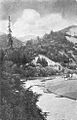
Russian River at Rio Nido, around 1910s
-
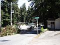
Village Square, Rio Nido, May 2008
-
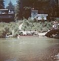
Rio Nido beach, 1963. The bridge is gone now.
-
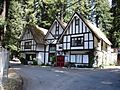
Rio Inn, 2008
-
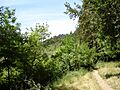
Trail to Russian River at Rio Nido, now covered with plants, 2008
.jpg)


