River Aller facts for kids
Quick facts for kids River Aller |
|
|---|---|

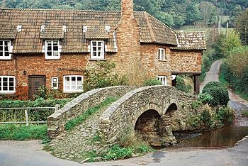
Packhorse Bridge, Allerford
|
|
| Country | England |
| State | Somerset |
| Region | Exmoor |
| District | West Somerset |
| City | Allerford |
| Physical characteristics | |
| Main source | Holnicote, West Somerset, Exmoor, Somerset, England 51°11′54″N 3°32′52″W / 51.19833°N 3.54778°W |
| River mouth | Porlock Bay, Bristol Channel near Hurlestone Point, Somerset, England 0 m (0 ft) 51°13′31″N 3°35′10″W / 51.22528°N 3.58611°W |
| Basin features | |
| Tributaries |
|
The River Aller is a small but interesting river located in Exmoor, a beautiful national park in Somerset, England. It's part of the amazing natural landscape of the area.
Contents
Exploring the River Aller
The River Aller starts its journey from several small streams. These tiny streams come together near places called Tivington and Huntscott. Imagine lots of little trickles of water joining up to form a bigger flow!
The River's Path
As the River Aller grows, it flows through the Holnicote Estate. This is a large and historic area. The river passes by the main part of the estate, known as Holnicote.
The Allerford Bridge
One of the most famous spots along the River Aller is in the village of Allerford. Here, the river flows under a very old bridge. This bridge is a packhorse bridge, which means it was built a long time ago, in medieval times. It was used by horses carrying goods on their backs. It's a really cool piece of history!
Where the River Ends
After passing through Allerford, the River Aller meets up with another river called the River Horner. Together, these rivers flow into Porlock Bay. This bay is part of the Bristol Channel, which is a large inlet of the Atlantic Ocean. The river's journey ends near a place called Hurlstone Point.
Understanding Flooding Risks
The area around the River Aller can sometimes be at risk of flooding. This is because of the type of rocks and soil in the ground, which is called its geology. When there's a lot of rain, the water might not drain away quickly enough.
To help keep people safe and manage this risk, some special systems have been suggested. These include:
- Telemetry monitoring: This means using technology to watch how much water is flowing in the river. It's like having a constant eye on the river's levels.
- Siren warning system: If the river levels get too high, a siren could sound to warn people nearby. This gives everyone time to prepare and stay safe.
These systems help local communities deal with heavy rainfall and protect homes and land from potential floods.
 | Audre Lorde |
 | John Berry Meachum |
 | Ferdinand Lee Barnett |

