River Ayr Way facts for kids
Quick facts for kids River Ayr Way |
|
|---|---|

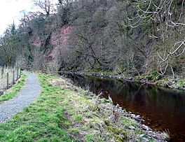
The River Ayr Way west of Catrine
|
|
| Length | 66 km (41 mi) |
| Location | Ayrshire, Scotland |
| Established | 2006 |
| Designation | Scotland's Great Trails |
| Trailheads | Glenbuck Loch55°32′13″N 3°58′26″W / 55.537°N 3.974°W Ayr55°28′08″N 4°38′31″W / 55.469°N 4.642°W |
| Use | Hiking |
| Elevation gain/loss | 470 metres (1,540 ft) gain |
| Lowest point | Sea level |
| Waymark | Yes |
| Website | https://eastayrshireleisure.com/countryside-outdoor/the-river-ayr-way/ |
The River Ayr Way is a special long walking path in Ayrshire, Scotland. It stretches for 66 kilometers (about 41 miles). This path follows the River Ayr from where it starts at Glenbuck Loch all the way to the sea at Ayr. When you reach Ayr, the path connects with another trail called the Ayrshire Coastal Path.
This walking route was created as part of a big project to help people explore the countryside, especially in areas that used to have coal mines. The River Ayr Way was officially opened in 2006 by a famous broadcaster named Fred Macaulay. Today, it's known as one of Scotland's Great Trails, which means it's a really important and well-loved path. In 2018, about 137,000 people walked on the path, and about 41,000 of them walked the whole way!
Running the Trail: The Ultramarathon
Every year, a very long running race called an ultramarathon takes place along the entire River Ayr Way. An ultramarathon is a running race that is longer than a traditional marathon (which is 42.195 kilometers or 26.2 miles). This race goes "downhill" from the river's source to the sea.
There's also a relay race, which means teams of two or three people can split the route. Each person runs one section of the path.
Race Sections
The River Ayr Way is divided into three main sections for the relay race:
- Section 1: From Glenbuck to Sorn, which is about 27 kilometers (17 miles) long.
- Section 2: From Sorn to Annbank, covering about 23 kilometers (14 miles).
- Section 3: From Annbank to Ayr, the final stretch of about 14 kilometers (9 miles).
 | Toni Morrison |
 | Barack Obama |
 | Martin Luther King Jr. |
 | Ralph Bunche |

