River Corve facts for kids
Quick facts for kids River Corve |
|
|---|---|

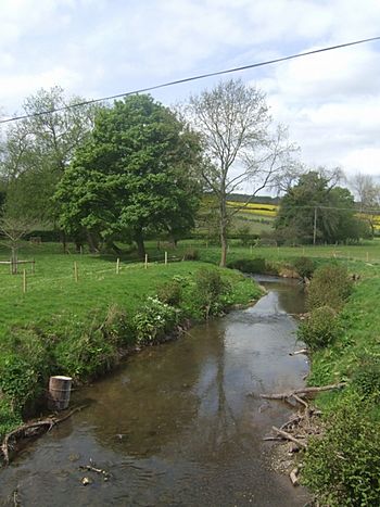
River Corve - upstream at Beambridge
|
|
| Country | England |
| Counties | Shropshire |
| City | Ludlow |
| Physical characteristics | |
| River mouth | Confluence with River Teme Ludlow, Shropshire, England 75 m (246 ft) |
| Basin features | |
| Tributaries |
|
The River Corve is a smaller river located in Shropshire, England. It is a tributary of the River Teme. A tributary is a smaller stream or river that flows into a larger one. The River Corve joins the River Teme in the town of Ludlow. The River Teme then flows into the River Severn near Worcester.
The area where the River Corve flows is known as the Corvedale. This name is often used to describe the whole region. For example, a primary school in Diddlebury uses this name. The river's name is sometimes spelled "Corf," which sounds like how it is pronounced.
Contents
Where Does the River Corve Flow?
The River Corve starts its journey near a place called Corfton. This place actually gets its name from the river itself! After Corfton, the river flows past Culmington.
It then continues through Stanton Lacy. Finally, it reaches the northwest edge of Ludlow. Just outside Ludlow, the River Corve meets the River Teme in an area of open meadows.
Historical Connections of the Corve
The river also gave its name to Corfham Castle. This castle is located near Peaton. Corfham was once a very important place. In medieval times, it was the main administrative center for two Saxon hundreds. A hundred was a type of land division. These hundreds, called Patton and Culvestan, covered the Corvedale area.
Later, during the reign of King Henry I, these two hundreds were combined. They became a single hundred known as Munslow. However, the name Culvestan was still used to describe the lower Corve valley for about a hundred years after that.
River Corve and Local Challenges
Rivers can face challenges, and the River Corve is no exception. In 2006, there was a pollution incident. Slurry from a livestock farm near Stanton Long entered the river. This caused fish to die, which was very sad for the river's ecosystem.
Flooding and Bridge Rebuilding
In 2007, the area experienced very heavy flooding. The River Corve rose quickly, about 1.6 meters (over 5 feet) in just three hours. During this flood, a house collapsed into the river. Also, the Burway Bridge collapsed. This bridge was a key connection for traffic on the B4361 Coronation Avenue, linking it to Ludlow town center.
To help people get around, a temporary Bailey bridge was put up. This helped reduce traffic problems while a new bridge was built. A modern new bridge was designed by Mouchel, a company from Shrewsbury. It was built by McPhillips (Wellington) Ltd. The new bridge was finished in 2008, restoring the important connection.
How the River Corve Area is Organized
The name "Corvedale" is also used for an electoral division. An electoral division is an area used for voting. This division elects one member to the Shropshire Council. In 2011, about 3,783 people lived in this ward. It covers a large countryside area. This area includes 13 different civil parishes, which are local government areas. It is even larger than what people usually think of as the Corvedale area.
The name "Corve" is also used for a parish ward in Ludlow. This ward elects two members to the Ludlow Town Council. It covers the northwest part of the town.
 | Madam C. J. Walker |
 | Janet Emerson Bashen |
 | Annie Turnbo Malone |
 | Maggie L. Walker |

