River John facts for kids
Quick facts for kids River John |
|
|---|---|

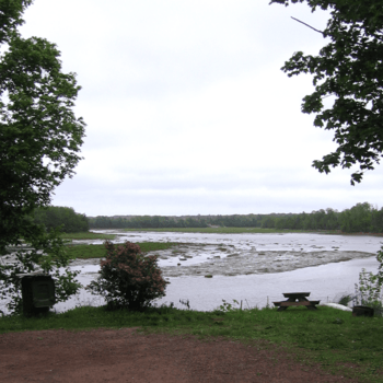
River John at low tide
|
|
| Country | Canada |
| Province | Nova Scotia |
| Physical characteristics | |
| River mouth | Northumberland Strait sea level |
| Basin features | |
| Basin size | 1,117 km2 (431 sq mi) |
River John is a river located in Nova Scotia, Canada. It flows through the western part of Pictou County. The river eventually empties into Amet Sound, which is part of the Northumberland Strait. The village of River John is named after this river.
The Miꞌkmaq people, who are the original inhabitants of this land, called the river Kajeboogwek. This name means "flowing through desert or solitary place." An older English name for the river was Deception River. The name "River John" is thought to come from the French name Rivière Jaune, given by the Acadians. It might also be named after nearby Cap Jean (now called Cape John). DesBarres, a famous mapmaker, included it as "River John" in his important map collection, Atlantic Neptune.
Contents
History of River John
Early Settlement
People began to settle permanently along River John in the late 1700s. These early settlers started building communities and farms along the riverbanks.
Shipbuilding on the River
During the 1800s, River John became a very important place for building wooden ships. Many large ships were constructed right on the river. These ships helped transport goods and people across the seas.
In 1884, two of the biggest ships ever built in Pictou County were launched here. The Warrior, weighing 1,687 tons, was built by the Kitchin yard. In the same year, a rival company, led by Archibald MacKenzie, launched the Caldera, which weighed 1,574 tons. These were huge ships for their time!
Communities and the River John Watershed
Towns Along the River
Several communities are located along the lower parts of River John. These include the village of River John itself, Marshville, and Welsford. Welsford was once known as River John Village.
Upper River Settlements
The upper parts of the river flow through the Cobequid Mountains. Settlements in this area began in the early 1800s. Some of these communities are West Branch River John, Diamond, Loganville, and Dalhousie Settlement.
River John's Watershed
A watershed is an area of land where all the water drains into a single river or body of water. The River John watershed includes all the land that drains into Amet Sound. In 2011, about 6,661 people lived within this watershed, according to estimates from the Province of Nova Scotia.
River John's Tides
The River John is a tidal river for some of its length. This means that the water level in the river changes with the ocean's tides. When the tide comes in, the river's water level rises. When the tide goes out, the water level drops.
 | Janet Taylor Pickett |
 | Synthia Saint James |
 | Howardena Pindell |
 | Faith Ringgold |

