
Cobequid Mountains facts for kids

The Cobequid Mountains, sometimes called the Cobequid Hills, are a mountain range located in Nova Scotia, Canada. They are found in the mainland part of the province.
Contents
How the Cobequid Mountains Formed
The Cobequid Mountains are part of the huge Appalachian Mountains system, which stretches across eastern North America. These mountains go from Cape Chignecto in western Cumberland County all the way to Pictou County in the east.
The story of the Cobequid Mountains began a very, very long time ago, during the Precambrian and Devonian ages. This means they are made up of different kinds of rock, like sediments, granites, and volcanic rock. All these rocks were squeezed and folded when huge landmasses, called continents, slowly moved and crashed into each other.
Millions of years ago, this part of Nova Scotia was right in the middle of a giant supercontinent called Pangaea. When different parts of Pangaea collided, it created the mountains we see today. Over millions of years, wind and water have worn down these mountains, making them lower and more like rolling hills.
Scientists believe that the northern part of Nova Scotia, where the Cobequid Mountains are, was once connected to what is now northern Europe. When this landmass crashed into a piece of land from present-day northern Africa, it shaped the landscape of Nova Scotia. You can still see a leftover fault line from this event, called the Cobequid-Chedabucto Fault. It runs along the southern side of the Cobequid Mountains, near the Minas Basin and Cobequid Bay.
Sometimes, people think the Cobequid Mountains extend into Antigonish County further east. However, that smaller mountain range is actually different and is called the Pictou-Antigonish Highlands.
Tallest Spots in the Cobequids
The highest point in the Cobequid Mountains is an unnamed peak located on the eastern side of the Wentworth Valley. It stands at about 365 m (1,198 ft) tall. Other tall peaks in the area include:
- Higgins Mountain (about 364 m (1,194 ft))
- Nuttby Mountain (about 360 m (1,181 ft))
- Dalhousie Mountain (about 335 m (1,099 ft))
- Mt. Thom (about 329 m (1,079 ft))
Water and Waterfalls
The Cobequid Mountains are full of freshwater lakes and springs. These are the starting points for many small rivers and streams. Some of these waters flow south into the Minas Basin, while others flow north into the Northumberland Strait.
On the southern slopes of the mountains, you can find many beautiful waterfalls. These waterfalls are created by steep cliffs, called escarpments, which were formed by ancient fault lines linked to the Fundy Basin.
Forests and Natural Resources
The forests covering the Cobequid Mountains are mostly made up of hardwood trees. You'll find lots of sugar maple (also known as 'rock maple') and yellow birch on the mountain slopes. In autumn, these trees put on a spectacular show with their bright, changing leaf colours!
In the deep valleys of streams and rivers, you'll mostly see red spruce trees. On the lower slopes, there's a mix of different trees like balsam fir, red spruce, black spruce, white spruce, paper birch, red maple, and silver maple (also called 'white maple').
The rocks in the Cobequid Mountains also hold valuable resources. There are several coal deposits found in different areas. These stretch across the northern side of the mountains in Cumberland County, from places like Joggins through River Hebert to Springhill. You can also find coal on the southern edge near Debert. In the past, iron ore was found in the igneous rocks near Londonderry.
Images for kids
-
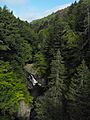
Waterfall on the Great Village River, one of many deeply cut rivers flowing out of the Cobequid Mountains of Nova Scotia.
