Cumberland County, Nova Scotia facts for kids
Quick facts for kids
Cumberland County
|
|||
|---|---|---|---|
|
County
|
|||
|
|||

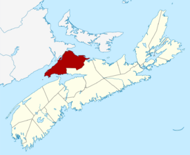
Location of Cumberland County, Nova Scotia
|
|||
| Country | Canada | ||
| Province | Nova Scotia | ||
| Towns | Amherst / Oxford | ||
| Established | August 17, 1759 | ||
| Incorporated | April 17, 1879 | ||
| Electoral Districts Federal |
Cumberland—Colchester |
||
| Provincial | Cumberland North / Cumberland South | ||
| Government | |||
| • Type | Cumberland County Municipal Council | ||
| Area | |||
| • Land | 4,275.77 km2 (1,650.88 sq mi) | ||
| Population
(2021)
|
|||
| • Total | 30,538 | ||
| • Density | 7.1/km2 (18/sq mi) | ||
| • Change 2011-16 | |||
| Time zone | UTC-4 (AST) | ||
| • Summer (DST) | UTC-3 (ADT) | ||
| Area code(s) | 902 | ||
| Dwellings | 18,445 | ||
| Median Income* | $38,433 CAD | ||
| Website | www.cumberland county.ns.ca | ||
|
|||
Cumberland County is a cool place in Nova Scotia, a province in Canada. It was named in 1755 after the Duke of Cumberland, a famous person from that time. The county officially started in 1759. It was later divided in 1840 to create new areas.
In the 1800s, Cumberland County was a busy place. People worked in lumbering, building ships, and mining coal. But in the 1900s, some people moved away. Also, many trees were cut down. This caused some communities to be left empty.
Today, Cumberland County covers about 4,275 square kilometers. It has lots of forests, different minerals, and farms. Farmers here grow many wild blueberries. In 2021, about 30,538 people lived in Cumberland County. Most of them live in the main county area. The county has two towns: Amherst and Oxford. It also has two larger communities, Parrsboro and Springhill, which are not officially towns.
Contents
History of Cumberland County
The name "Cumberland" was given by Lieutenant-Colonel Robert Monckton. He named it on June 18, 1755, after capturing a fort called Fort Beauséjour. He chose the name to honor William Augustus, Duke of Cumberland. The Duke was a son of King George II. He was also a military leader. The local Mi'kmaq people called this area "Kwesomalegek," which means "hardwood point."
Cumberland County was officially founded on August 17, 1759. In 1840, the area of Parrsboro was split. One part joined Cumberland County, and the other part joined Colchester County. The border between Cumberland and Colchester counties was set in 1840. It was made even clearer in 1897.
The 1800s were a time of growth for the county. Lumbering, shipbuilding, and coal mining were very important jobs. But in the 1900s, many trees were cut down. Also, people started moving to bigger cities. This led to some communities, like Eatonville and New Yarmouth, becoming empty.
Geography and Natural Resources
Cumberland County is a large area, covering about 4,271 square kilometers. It has many natural resources. There are huge forests that provide wood for lumber mills. The county also has several mineral resources. For example, there are two salt mines that are still working today. In the past, until the 1970s, there were also many coal mines. These mines dug for coal in areas like Joggins and Springhill.
Farming is also important here. Many farmers focus on harvesting wild blueberries. These grow in the Cobequid Hills. There are also mixed farms in other areas. These include the Tantramar Marshes, the Northumberland Strait coast, and the Wentworth Valley.
The western part of Cumberland County is special. It's part of the Isthmus of Chignecto. This is a narrow strip of land that connects the Nova Scotia peninsula to the rest of North America. Because of this, important roads and railways pass through the county. These include Highway 104, which is part of the Trans-Canada Highway. The CN Rail line from Halifax to Montreal also runs through here. The border with New Brunswick is about 30 kilometers long.
Cumberland County has two official towns: Amherst and Oxford. There are also two other large communities, Parrsboro and Springhill. These places have more than 1,000 people. However, they do not have their own town governments.
Population and Communities
In 2021, the population of Cumberland County was 30,538 people. This means there were about 7 people living in each square kilometer. Most of these people live in the main part of the county. The county has many homes, with about 14,139 homes being lived in.
Towns and Villages
Cumberland County is home to several communities.
- Towns
- Villages
- County municipality and county subdivisions
- Municipality of the County of Cumberland
- Cumberland Subdivision A
- Cumberland Subdivision B
- Cumberland Subdivision C
- Cumberland Subdivision D
Highways in Cumberland County
The county has several important highways that connect its communities and link it to other parts of Nova Scotia and Canada.
 Trunk 2
 Trunk 4
 Trunk 6
 Hwy 104 (TCH)
 Hwy 142
 Route 204
 Route 209
 Route 321
See also
- List of municipalities in Nova Scotia
- Central Nova Tourist Association — This group helps promote tourism in Cumberland County.
- Royal eponyms in Canada
- Black Lake listings within Nova Scotia.
 | Percy Lavon Julian |
 | Katherine Johnson |
 | George Washington Carver |
 | Annie Easley |


