
Tantramar Marshes facts for kids
The Tantramar Marshes, also known as the Tintamarre National Wildlife Area, is a large area of flat, wet land near the Bay of Fundy in Canada. It's located where the land narrows between New Brunswick and Nova Scotia, close to Sackville, New Brunswick. This special place is a tidal saltmarsh, meaning it's a marsh that gets covered by ocean water when the tide comes in.
This marsh covers a huge area of 20,230 hectares, making it one of the biggest saltmarshes on the Atlantic Ocean coast of North America. It's a very important resting spot for many birds that are migrating, like tiny semi-palmated sandpipers and large Canada geese. Because it's so important for wildlife, the Tantramar Marshes are now a National Wildlife Area and have two special bird sanctuaries where birds are protected.
The name Tantramar comes from an old French word, tintamarre, which means 'a loud noise' or 'racket'. This name was given because of all the noisy birds that gather there to feed. The beautiful landscape of the Tantramar Marshes has inspired many artists, including poets like Charles G.D. Roberts and Elizabeth Bishop, and painters like Alex Colville.
Several communities are located near or on the marshes. In New Brunswick, these include Aulac and Sackville. On the Nova Scotia side, you'll find Amherst and Fort Lawrence.
Contents
What is the Natural Environment Like?
The Tantramar Marshes are mostly flat lands that sit just above sea level. The soil here is made of fine dirt called silt, which has been brought in and left behind by ocean tides over hundreds of years. Because the land is so flat and the soil is silty, water doesn't drain away quickly. This creates slow-moving, winding rivers, shallow lakes, and wet, spongy areas called bogs.
These wet conditions are perfect for plants like sedges (which look like grasses) and tamarack trees. The areas where the land meets the water, called intertidal zones, are home to many different kinds of freshwater and estuarine (a mix of fresh and salt water) animals and plants. Several rivers flow through the marsh, including the Aulac, LaPlanche, Missaguash, and Tantramar Rivers.
A Look at the History of the Marshes
The Tantramar Marshes have a long and interesting history, especially regarding how people have lived and worked there.
Early Settlers and Farming
Long before Europeans arrived, Indigenous peoples used well-known paths across the marshes to travel between the Bay of Fundy and the Northumberland Strait. Around 1671, a group of French settlers called Acadians moved from Port Royal and started a village in this area, which they named Beaubassin. They built small settlements on higher ground.
The Acadians were very clever farmers. They built special walls called dykes and water gates called sluices to control the tides. This helped them turn the salty marshland into rich fields and pastures for farming.
Changes After Conflicts
In 1755, after a battle at Fort Beauséjour that ended the fight between the British and French for control of Acadia, the Acadians were forced to leave their homes. This event is known as the expulsion of the Acadians. Six years later, British settlers moved into the area and continued to turn the marsh into farmland.
Over time, land ownership became more organized, and a group called the Commission of Sewers was created to manage the dykes and drainage, which was very important for the economy. By the mid-1800s, about 10,000 hectares of the marsh were used to grow grains, root vegetables, and marsh hay.
Hay Farming and Decline
Once the land was drained, it was cheap to produce hay. Tantramar hay was sold to lumber camps, mining operations, and even stables as far away as Boston. In the 1930s, there were more than 400 large post-and-beam barns on the marshes used to store hay. Today, fewer than 30 of these barns remain.
The price of hay dropped sharply as cars replaced horses. In 1920, hay cost $28 per ton, but by 1938, it was only $7 a ton. Because farming hay became less profitable, much of the marshland was then used for pasture (where animals graze). As farming declined, organizations like the Canadian Wildlife Service and Ducks Unlimited helped to return parts of the marshes to their natural state, making them better for wildlife again.
Modern Challenges and Uses
After 2010, people became worried that rising sea levels and the aging 18th-century dykes could flood the Tantramar Marshes. This could even make Nova Scotia an island, separated from the rest of North America.
In 1945, Radio Canada International built a radio transmitter station on the marshes. This location turned out to be one of the best in the world for sending shortwave radio signals. However, shortwave broadcasting ended in 2012, and the tall transmitting towers have since been taken down. In 2017, the land where the station was located was sold to a group of New Brunswick Mi'kmaq bands.
Images for kids
-
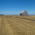
A hay barn, once common on the Tantramar Marsh.
-

The former RCI transmitter station in 2009.


