
Fort Beauséjour facts for kids
Quick facts for kids Fort Beauséjour |
|
|---|---|
| Aulac, New Brunswick | |

Fort Beauséjour and Cathedral (c. 1755)
|
|
| Coordinates | 45°51′53″N 64°17′29″W / 45.86472°N 64.29139°W |
| Type | Fortress |
| Site information | |
| Controlled by | France (1751–1755), United Kingdom (1755–1835), Parks Canada (1926–present) |
| Official name: Fort Beauséjour – Fort Cumberland National Historic Site of Canada | |
| Designated: | 1920 |
| Site history | |
| Built | 1751 |
| In use | 1751–1835 |
Fort Beauséjour, later called Fort Cumberland, was a big fort in eastern Canada. It was built on a narrow strip of land called the Isthmus of Chignecto, which connects New Brunswick and Nova Scotia today. This spot was very important for Acadia, a French colony that covered parts of what are now the Maritimes, Quebec, and northern Maine.
The French built the fort between 1751 and 1752. But in 1755, during the Seven Years' War, they lost it to the British in the Battle of Fort Beauséjour. The British then renamed it Fort Cumberland. This fort was a key place during the time when France and Britain were often fighting, from 1749 to 1763. Years later, in 1776, it was also the site of the Battle of Fort Cumberland, where British soldiers stopped attacks from people who supported the American Revolution.
Since 1920, the fort has been a National Historic Site of Canada. It's called the Fort Beauséjour – Fort Cumberland National Historic Site. Parts of the fort have been fixed up, and there's a museum and visitor center. About 6,000 people visit the fort every year.
Contents
Why Fort Beauséjour Was Important
Europe's Wars Come to North America
For hundreds of years, European countries like France and Britain were often at war. These wars sometimes spread to their colonies around the world, including North America. New France, the French colony in North America, was always worried about attacks from the British. Acadia, a part of New France, was especially easy to attack by water.
The capital of Acadia, Port-Royal, was founded in 1605. It was destroyed by the British in 1613 and attacked many times after that. Finally, in 1710, the British took control of Port-Royal for good.
The Treaty of Utrecht and Border Disputes
In 1713, a peace agreement called the Treaty of Utrecht was signed. This treaty said that France had to give the land we now call mainland Nova Scotia to Great Britain. However, France kept control of Cape Breton Island and Prince Edward Island. The treaty didn't clearly say where the border was between French Canada and British Nova Scotia.
Because of this, the unofficial border became the Missiguash River on the Isthmus of Chignecto. This area was home to a successful Acadian village called Beaubassin.
Growing Tensions Between France and Britain
By the mid-1700s, France and Britain were getting ready for another big war, the Seven Years' War. At this time, over a million British colonists lived along the Atlantic coast. New France had about 70,000 people, with about 18,544 of them living in what is now the Maritimes.
Building Fort Beauséjour

As the disagreements grew, the British started building forts in Nova Scotia in 1749. They built Citadel Hill in Halifax (which they also founded as a town) and Fort Sackville in Bedford. The French also got ready. They rebuilt the Fortress of Louisbourg and took back Fort Nerepis to help protect their lands.
In 1750, the French sent more soldiers to their colony. That same year, the British Governor of Nova Scotia, Edward Cornwallis, sent Major Charles Lawrence with a small group of soldiers to show British power in the Chignecto area. On the north side of the Missaguash River, Lawrence found French soldiers led by Louis de La Corne. De La Corne had orders to stop the British from moving forward. He even burned the village of Beaubassin to prevent the British from using it. Lawrence decided not to fight and pulled back.
After some debate, Governor Cornwallis sent Lawrence back to the Missaguash River with more soldiers. They defeated a group of Indigenous people and their French leader, Father Le Loutre. In the fall of 1750, Lawrence built Fort Lawrence near the burned village of Beaubassin.

In November 1750, the French Governor General, de la Jonquière, ordered two new forts to be built at each end of the Isthmus of Chignecto to stop the British. One was Fort Gaspareaux on the Northumberland Strait, and the other was Fort Beauséjour on the Bay of Fundy.
Construction of Fort Beauséjour began in April 1751. By 1751, the gunpowder magazine (where gunpowder was stored), a well, four casemates (bomb-proof rooms), and officers' living quarters were finished. The soldiers' barracks were added the next year. By 1753, the fort had palisade walls and an earth wall about 5 meters (16 feet) high. It was shaped like a pentagon (a five-sided shape) with strong corners called bastions, made of earth and wooden stakes.
In 1754, Louis Du Pont Duchambon de Vergor became the commander of Fort Beauséjour. It later became clear that he was not a good military leader.
The Battle of Fort Beauséjour

The French position at the fort might have been weakened by Thomas Pichon, a clerk who worked there. The British commander at Fort Lawrence paid Pichon for information about what the French were doing. Pichon gave them details about French activities, maps of the forts, and ideas on how to capture them. Lieutenant-Colonel Robert Monckton later used this information in his attacks. Pichon even told the French that the British wouldn't attack that year, which made them delay strengthening Fort Beauséjour.
On May 19, 1755, a group of 31 transport ships and three warships left Boston. They carried almost 2,000 soldiers from New England and 270 British regular soldiers. They arrived near the mouth of the Missaguash River on June 2. The next day, the soldiers, led by Lieutenant-Colonel Robert Monckton, landed a few kilometers from Fort Beauséjour.
To defend the fort, Commander Louis Du Pont Duchambon de Vergor had only 150 soldiers and about a dozen gunners. On June 16, a large British bomb went through the roof of a casemate and killed many people inside. Vergor decided to surrender. The fort was given to the British and renamed Fort Cumberland. The very next day, Fort Gaspereau also surrendered without a fight. The capture of these forts settled the border dispute in favor of the British. It also marked the beginning of the Expulsion of the Acadians.
Fort Cumberland and Its Later Years

After the British captured the fort, they ordered the Acadians living nearby to sign an oath of loyalty to the British king. However, the Acadians refused, wanting to stay neutral. Some Acadians said they were forced to help defend Fort Beauséjour. The British used this as a reason to start the Expulsion of the Acadians, forcing many Acadians from their homes. Acadian homes were burned to stop them from returning.
The British army moved to Fort Cumberland and abandoned and burned Fort Lawrence in October 1756. Fort Cumberland became one of the places where the British held Acadians during the nine years of the expulsion.
Acadians and Mi'kmaq people, led by French officer Boishébert, fought against being forced from their homeland. They attacked British soldiers and rangers near Fort Cumberland several times between 1756 and 1761.
In 1776, at the start of the American Revolutionary War, Fort Cumberland and its soldiers stopped several attacks in the Battle of Fort Cumberland. These attacks were led by Jonathan Eddy, who supported the American rebels.
After the Revolutionary War ended and the United States became independent, the British left Fort Cumberland in the late 1780s. When fighting with the United States started again in the War of 1812, Britain sent soldiers to fix up the fort and guard it. However, there was no fighting at the fort during that war. In 1835, the British military decided the fort was no longer needed and left it for good.
Fort Beauséjour – Fort Cumberland National Historic Site
In 1920, the fort was named a National Historic Site of Canada. This was because of its important role in the history of both France and Britain in Canada. It is now called the Fort Beauséjour – Fort Cumberland National Historic Site. Parts of the fort have been repaired and restored. There is also a museum and visitor center for people to learn more.
The museum tells the story of the conflicts between France and Great Britain in the 1700s. It also covers the later struggle between the American rebels and Britain. About 6,000 people visit the fort each year, making it an important place for heritage tourism in the Maritimes.
Images for kids
-
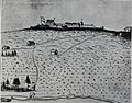
Fort Beauséjour in 1755 by Winckworth Tonge
-
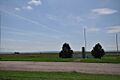
Marker at the site of Beaubassin


See also
 In Spanish: Fuerte Beauséjour para niños
