Minas Basin facts for kids
Quick facts for kids Minas Basin |
|
|---|---|
| French: Bassin des Mines | |

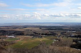
Looking east across the Southern Bight of Minas Basin from The Lookoff
|
|
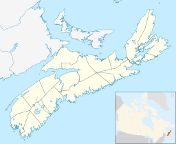
| Location | Nova Scotia |
| Coordinates | 45°15′N 64°10′W / 45.250°N 64.167°W |
| Type | Inlet |
| Part of | Bay of Fundy |
| Settlements | Truro, Wolfville, Parrsboro |
| Official name: Southern Bight-Minas Basin | |
| Designated: | 5 November 1987 |
| Reference #: | 379 |
The Minas Basin (which is called Bassin des Mines in French) is a part of the Bay of Fundy. It is located in Nova Scotia, Canada. This area is famous for having some of the highest tides in the world.
Contents
Geography of Minas Basin
The Minas Basin is the eastern part of the Bay of Fundy. The Bay of Fundy splits near Cape Chignecto. The Minas Basin is marked by large rock formations called Cape Split and Cape d'Or.
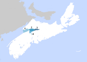
The Minas Basin has four main areas:
- The Minas Channel: This is the entrance, between Parrsboro and Cape Blomidon.
- Central Minas Basin: This area goes from the Minas Channel to the start of Cobequid Bay.
- Cobequid Bay: This part reaches all the way to the Salmon River.
- The Southern Bight: This section stretches from the Avon River to the Noel Shore.
Many large rivers flow into the Minas Basin. These include the Shubenacadie River, Cornwallis River, Avon River, Gaspereau River, and Salmon River. Along the northern side of the basin, there are high cliffs and islands made of basalt rock. These are known as the Basalt Headlands.
People have created large areas of farmland along the northern shore and near the Gaspereau and Salmon Rivers. They did this by building dykes. These dykes have special gates called sluices that let water out but not in. This way of creating land is called polderisation.
Amazing Tides of Minas Basin
Burntcoat Head is on the south side of the Minas Basin. It holds the record for the highest tidal range ever measured. The water level can change by more than 16 meters (about 52 feet) during a spring tide. It also has one of the highest average tidal ranges every single day.
The water in Minas Bay moves in and out of the main Bay of Fundy through the Minas Channel. This creates incredibly strong tidal currents. Near Cape d'Or, the clashing currents are so strong they are called the Dory Rips. The water in the Minas Basin is a thick, reddish-brown color. This is because of all the silt (fine dirt) that the strong tides constantly stir up.
At mid-tide, the currents can move faster than 8 knots (about 4 meters per second). The amount of water flowing through the deep channel on the north side of Cape Split is amazing. It's equal to the combined flow of all the rivers and streams on Earth put together! That's about 4 cubic kilometers (1 cubic mile) of water every hour.
Communities and Parks
Many towns and villages are located along the Minas Basin or its rivers. The largest town is Truro, found at the end of Cobequid Bay. Other smaller towns include Parrsboro, Wolfville, and Windsor.
For over 200 years, ferries connected the north and south sides of the basin. The last ferry was called the MV Kipawo. Its name came from the three communities it connected: Kingsport, Parrsboro, and Wolfville.
Parks to Explore
Several provincial parks let visitors enjoy the Minas Basin. These include Anthony (near Truro), Five Islands, and Cape Blomidon. There are also community parks that highlight the basin. These include the Kingsport waterfront, the Walton Lighthouse, and the Burntcoat Head Lighthouse.
History of the Area
Early Settlement
The Mi'kmaq were the first people to live around the Minas Basin. Mi'kmaq stories connect their god Glooscap to important places like Cape Blomidon and Five Islands.
European explorers and traders arrived in the early 1600s. One of them was the French explorer Samuel de Champlain. In 1607, he explored the copper deposits at Cape d'Or, which is at the entrance to the Basin. Champlain named the nearby Advocate Harbour "Port of Mines" because of the copper ore. Even though the French did not start a mine, the name "Les Mines" stuck. It became associated with the upper Bay of Fundy, which was called "Baie des Mines." This name was later changed to Minas Basin in English.
French Acadian settlements began in the late 1600s. They settled around the southern shore of the Minas Basin, an area known as Les Mines. The Acadians had a big impact on the area. They created a lot of farmland by building dykes and aboiteaux. These are special systems to reclaim land from the sea. They founded communities like Grand-Pré and Cobequid. Even today, their dyke systems are still used near Truro and Wolfville.
In 1755, the British forced over 12,000 Acadians to leave their homes. This event is known as the Great Expulsion.
After the Acadians left, new settlers arrived. These were the New England Planters in 1760, followed by Loyalists in the 1780s. The Planters continued to use the ferry system. They also rebuilt and expanded the Acadian dyke systems. This helped them create even more farmland from the Basin.
Industry and Resources
The communities around the Minas Basin relied on many different jobs. These included fishing, logging, farming, mining, and boat building. In the late 1800s, the shipyards in the Basin built many wooden ships. Some were very large, like the William D. Lawrence, the biggest wooden ship ever built in Canada.
The strong tides also helped transport goods. Lumber, apples, and gypsum were moved by water. The tides even powered Tide mills in places like Canning and Hantsport.
Mining was also important. People mined gypsum (used in drywall), iron, barite, manganese, and copper. Gypsum was shipped from Hantsport until 2009.
There have been attempts to use the powerful tides of the Minas Basin to create energy. However, these attempts have not been successful so far.
Nature and Fossils
The Minas Basin is home to many different animals. Marine mammals like seals and porpoises can be seen. Many types of fish live here, including bass, shad, and flounder. You can also find lobster, crab, mussels, and clams. The area also has many kinds of seaweed, sponges, worms, and sea jellys.
Many birds visit or live here. These include sandpipers, terns, eagles, falcons, seagulls, herons, and kingfishers.
Amazing Fossils and Minerals
Fossils are often found near Parrsboro, Blue Beach, and other areas along the Avon River. Sometimes, fossils are also found at Evangeline Beach and Burntcoat Head. These fossils include shells, sponges, trees, fish, amphibians, reptiles, and even dinosaurs.
Scientists also find trace fossils here. These are not the animals themselves, but signs they were there. They include vertebrate footprints, fish fin-tracks, and invertebrate trackways (like scorpion tracks). You can also see raindrop imprints and wave ripples in the rocks. These fossils show that the region was once warm and tropical, then covered by a shallow sea, and later became a desert. The fossils range from the beginning of the Carboniferous period to the Jurassic period.
The basalt cliffs at Cape Split and around Parrsboro are rich in minerals. Many types of zeolites are found here. Nova Scotia's provincial mineral, stilbite, is one of them. Other minerals include heulandite, analcime, and chabazite. You can also find calcite, magnetite, copper, and quartz (often as amethyst). Beautiful agate is also common. In the sedimentary rocks, gypsum is often found. Other minerals from these rocks include pyrite, barite, and manganite.
 | Mary Eliza Mahoney |
 | Susie King Taylor |
 | Ida Gray |
 | Eliza Ann Grier |


