River Lydden facts for kids
Quick facts for kids River Lydden |
|
|---|---|

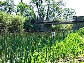
River Lydden at Bagber Bridge
|
|
|
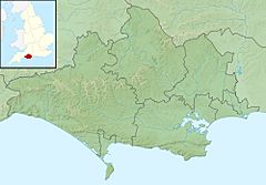
Location within Dorset
|
|
| Country | England |
| County | Dorset |
| Physical characteristics | |
| Main source | Buckland Newton |
| River mouth | River Stour 50°57′09″N 2°20′01″W / 50.9524°N 2.3336°W |
| Length | 24.55 km (15.25 mi) |
The River Lydden is a river in Dorset, England. It is about 24.55 kilometers (or 15.25 miles) long. The River Lydden is a smaller river that flows into a larger one, the River Stour. It travels through a beautiful area called Blackmore Vale.
Contents
About the River Lydden
The River Lydden is an important part of the natural landscape in Dorset. It helps shape the land and provides a home for many plants and animals. Understanding rivers like the Lydden helps us learn about geography and the environment.
Where Does the River Lydden Start?
The River Lydden begins its journey in the Dorset Downs. Its very first streams, called headwaters, start near a village called Buckland Newton. These small streams come together to form the main river.
The River's Journey
After starting near Buckland Newton, the small streams join up south of Pulham. From there, the river flows towards the north-east. It then meets another small stream called the Wonston Brook.
The River Lydden continues its path north. It flows past a place called King's Stag. Later, it reaches Twoford Bridge, where a main road, the A357, crosses over it. This crossing is between the villages of Lydlinch and Bagber.
Meeting Other Streams
After Twoford Bridge, the River Lydden meets its most important tributary. A tributary is a smaller river or stream that flows into a larger one. The main tributary for the Lydden is the Caundle Brook.
The lower part of the River Lydden then flows under the historic Bagber Bridge. This bridge is a special, protected structure. Finally, the River Lydden joins the much larger River Stour. This meeting point is near King's Mill, south-west of Marnhull.
 | Mary Eliza Mahoney |
 | Susie King Taylor |
 | Ida Gray |
 | Eliza Ann Grier |


