
Rivière au Saumon (Le Haut-Saint-François) facts for kids
Quick facts for kids Rivière au Saumon |
|
|---|---|
| Country | Canada |
| Province | Quebec |
| Region | Estrie |
| MRC | Le Haut-Saint-François Regional County Municipality |
| Municipality | Weedon |
| Physical characteristics | |
| Main source | Lake Danger Weedon 631 m (2,070 ft) 45°19′42″N 71°00′21″W / 45.32833°N 71.00583°W |
| River mouth | Saint-François River Weedon 250 m (820 ft) 45°40′58″N 71°26′43″W / 45.68278°N 71.44528°W |
| Length | 77.0 km (47.8 mi) |
| Basin features | |
| Progression | Saint-François River, Saint Lawrence River |
| Tributaries |
|

The Rivière au Saumon (which means Salmon River in English) is a river in Quebec, Canada. It flows into the Saint-François River. This river is found in the Estrie region of Quebec.
The river flows through several towns. These include Notre-Dame-des-Bois, La Patrie, Hampden, Lingwick, and Weedon.
People in this area mostly work in forestry (cutting trees) and agriculture (farming). The river usually freezes from mid-December to mid-March. It's safest to walk on the ice from late December to early March.
Contents
Where the Salmon River Flows
The Rivière au Saumon starts in a small lake called Danger Lake. This lake is about 0.175 kilometers long and sits high up at 631 meters. It's located close to the United States border.
The river flows north for about 77 kilometers. It eventually joins the Saint-François River.
Neighboring Rivers
Other rivers and streams are close to the Rivière au Saumon.
- To the north is the Saint-François River.
- To the east are the Chesham River and the Rouge River (rivière au Saumon).
- To the south are the Ditton River, North Eaton River, and Bown Creek.
- To the west is the Eaton River.
River Branches and Floods
The Rivière au Saumon has two main parts. One is the southern branch, which is the Ditton River. The other is the eastern branch.
Sometimes, the river can have sudden floods. This happens when a lot of water makes the river overflow its banks. It can cover the low-lying areas next to the river. Long ago, settlers used the river for transportation with fishing boats.
The Ditton River joins the Rivière au Saumon near the village of La Patrie. The river then continues towards Scotstown and Lingwick. Near Fontainebleau, it flows under the McVetty-McKenzie Bridge. Finally, it flows into the Saint-François River at Weedon. Because the Salmon River flows faster than the Saint-François River, many spring floods happen in this area.
The River's Journey
From Danger Lake, the Salmon River drops 388 meters over its 77-kilometer journey.
Upper Part of the River
The first 41.1 kilometers of the river's journey are called the upper course.
- For 17.5 kilometers, it flows west. It forms many small streams through forests and farms. It enters La Patrie and collects water from the Morin stream. It also meets the Chesham River.
- For 6.7 kilometers, it flows west in a large curve to the north. It collects water from the Audet, Desaultels, and Beauregard rivers. It also takes in the Ditton River from the south.
- For 5.6 kilometers, it flows north through farms. It crosses Route 212 East near La Patrie. It also collects water from the Fortier stream. This part of the river flows west of Mont-Mégantic National Park.
- For 6.4 kilometers, it flows northwest, making two loops to the east. It collects water from a mountain stream and the McLoed stream.
- For 4.9 kilometers, it flows northwest into Hampden. It makes a loop to the northeast and then enters Scotstown. Here, the river widens on the northeast side of Scotstown village. It also collects water from Dell Brook. This part of the river forms the western edge of Marécage des Scots Regional Park.
Lower Part of the River
The next 35.9 kilometers are the lower course of the river.
- For 12.4 kilometers, it flows west, passing north of Scotstown village. It goes into a deep valley and enters Lingwick. It collects water from Dutch Creek and Bown Creek.
- For 8.5 kilometers, it flows northwest, crossing Route 108. It makes a loop before collecting water from McGill stream. This stream flows from Lake McGill and Lake Moffatt.
- For 4.9 kilometers, it flows north, going around an island and making a loop to the east. It collects water from another stream.
- For 10.1 kilometers, it first flows northwest into Weedon. It crosses the Rivière au Saumon path south of Fontainebleau village. Then it flows west to its end point.
What's in a Name?
The name "Rivière au Saumon" means "Salmon River." This name was officially recognized on December 5, 1968, by the Commission de toponymie du Québec (Quebec's Place Names Commission).
Images for kids
-
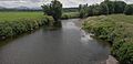
Salmon river near La Patrie. The northern flank of the White Mountains is in the background. The river has its source there.
-
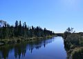
Rivière au Saumon at the Chemin du Quatre Milles bridge which leads to Rang Cohoes between Scotstown and La Patrie.
-
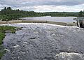
Salmon River in Scotstown.
-
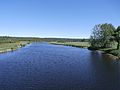
Rivière au Saumon upstream from the bridge over Chemin de la Rivière aux Saumons near Fontainebleau (Weedon).


