
Rivière des Hurons (Richelieu River tributary) facts for kids
Quick facts for kids Rivière des Hurons |
|
|---|---|

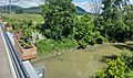
Bridge spanning the Huron River on the Route des patriotes near the mouth of the river.
|
|
| Country | Canada |
| Province | Quebec |
| Region | Montérégie |
| Regional County Municipality | Les Maskoutains Regional County Municipality, La Vallée-du-Richelieu Regional County Municipality, Rouville Regional County Municipality |
| Municipality | La Présentation, Saint-Charles-sur-Richelieu, Sainte-Marie-Madeleine, Sainte-Madeleine, Saint-Jean-Baptiste, Saint-Mathias-sur-Richelieu |
| Physical characteristics | |
| Main source | Agricultural stream La Présentation 34 m (112 ft) 45°37′30″N 73°03′01″W / 45.62513°N 73.05025°W |
| River mouth | Richelieu River Saint-Mathias-sur-Richelieu 10 m (33 ft) 45°27′35″N 73°15′44″W / 45.45972°N 73.26222°W |
| Length | 33 km (21 mi) |
| Basin features | |
| Tributaries |
|
The Rivière des Hurons (which means Hurons River in English) is a river in Quebec, Canada. It flows for about 33 kilometers (20.5 miles) before joining the Richelieu River. The river's mouth is near the town of Saint-Mathias-sur-Richelieu.
This river is important for the local economy, especially for farming. The area around the river is mostly used for agriculture. The river's water level changes with the seasons and how much rain falls. In winter, the river usually freezes from mid-December to late March.
Contents
River's Journey and Location
The Rivière des Hurons starts in the northwest part of Saint-Hyacinthe. It begins from many small streams in areas like La Présentation and Sainte-Marie-Madeleine.
Flowing South Through Towns
From its source, the river generally flows south. It crosses under Highway 20 and passes near the La Madeleine Golf Club. It also goes under the Canadian National Railway tracks and Highway 116.
As it continues south, the river turns southwest. It flows through Saint-Jean-Baptiste for about 9.4 kilometers (5.8 miles). The river then passes between Mont Rougemont and Mont Saint-Hilaire, though it stays some distance away from them.
Reaching the Richelieu River
The river flows almost straight until it reaches the border of Saint-Mathias-sur-Richelieu. It then crosses this area diagonally for about 9.7 kilometers (6 miles). Finally, it flows into the Richelieu River, south of Saint-Mathias-sur-Richelieu village.
Roads Along the River
In farming areas, Highway 227 runs along the east side of the river. This road is sometimes called "row South River." On the west side, the road is known as "North River Row." In Saint-Mathias-sur-Richelieu, "Huron River East" road follows the river to its end. "West Huron River" road runs along the other side for a part of the river.
The Rivière des Hurons has a gentle slope. This means its current is not very strong. During times of high water, like after heavy rain, small boats might be able to travel on some parts of the river. Many small farm bridges cross the river, especially in its northern sections.
History of the Huron River Area
For thousands of years, before Europeans arrived, the area around the Rivière des Hurons was important for Native American communities. They used the river and its surroundings for hunting, fishing, and farming. These groups were often semi-nomadic, meaning they moved around during different seasons.
European Settlement
European settlers, or their descendants, began to move into this area in the late 1600s. They mostly settled near the Richelieu River. This was a time when the fur trade was very active between the French and Native American communities.
How the River Got its Name
The name "Rivière des Hurons" has a long history. In October 1673, early land records from the Lord of Chambly already called the river "the Huron." About a century later, people started calling it "Hurons River." This name was officially noted in documents from 1773.
During the early days of the French colony in Canada, many Iroquois and Huron villages were located near the Richelieu River. They traded furs with the French and exchanged goods with other Native American groups. Many Indigenous communities chose to live near French settlements for safety and to get supplies.
The name "Huron River" was officially recognized on December 5, 1968, by the Geographical Names Board of Québec.
Images for kids
-
View of the Rivière des Hurons passing under the Chemin de Rouville bridge, in Saint-Jean-Baptiste, Quebec, with Mont Saint-Hilaire in the background
-Rivi%C3%A8re_Des_Hurons_et_ponts_du_chemin_de_Rouville-2022-06-14.jpg)
