Rivière du Cap Rouge facts for kids
Quick facts for kids Cap-Rouge river |
|
|---|---|

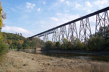
The river passing under the Cap-Rouge trestle
|
|
|
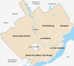
Location of the mouth of the river in Quebec City
|
|
| Native name | Rivière du Cap-Rouge |
| Country | Canada |
| Province | Quebec |
| Region | Capitale-Nationale |
| Cities | Quebec City, Saint-Augustin-de-Desmaures |
| Physical characteristics | |
| Main source | Forest stream Saint-Augustin-de-Desmaures 134 m |
| River mouth | Saint Lawrence River Cap-Rouge 4 m 46°44′55″N 71°20′35″W / 46.7486111°N 71.3430556°W |
| Length | 23.9 km (14.9 mi) |
| Basin features | |
| River system | Saint Lawrence River |
| Basin size | 82 km2 (32 sq mi) |
| Bridges | Cap-Rouge trestle |
The Cap-Rouge river (also called Rivière du Cap Rouge in French) is a river in Quebec, Canada. It flows on the north side of the mighty Saint Lawrence River. You can find it near the Quebec City area, specifically in the Sainte-Foy–Sillery–Cap-Rouge part of the city and in Saint-Augustin-de-Desmaures.
The river's water comes from a large area called a watershed. This watershed includes parts of Saint-Augustin-de-Desmaures, L'Ancienne-Lorette, and Quebec City. The Cap-Rouge river valley is easy to reach by several roads, like route 367 and route 138.
During winter, the river usually freezes over from early December to late March. It's generally safe to walk on the ice from late December to early March. The amount of water in the river changes with the seasons and how much rain or snow falls. The biggest flow of water, called the spring flood, happens in March or April.
About the Cap-Rouge River
The Cap-Rouge River starts on the slopes of Mount Bélair and the Butte du Petit-Capsa. These are small hills at the edge of the Laurentian Mountains. From there, the river flows for about 23.5 kilometers (14.6 miles). It finally joins the Saint Lawrence River in the Cap-Rouge neighborhood of Quebec City.
This meeting point of the two rivers is very special. It's where the Charlesbourg-Royal site is located. This was the first known French settlement in North America, a very important historical spot!
River's Journey and Surroundings
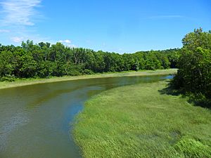
The Cap-Rouge River's watershed covers about 82 square kilometers (31.7 square miles). This area includes parts of La Jacques-Cartier Regional County Municipality, L'Ancienne-Lorette, La Haute-Saint-Charles, and Saint-Augustin-de-Desmaures. Some farming happens in these areas. This means there's a small risk of water pollution from farms. However, tests in 2016 showed that levels of things like ammonia, nitrates, and phosphorus in the water were all "good."
Other rivers and streams nearby include the Noire River to the west and the Lorette River to the north. As the Cap-Rouge River flows, it passes through different parts of Quebec City. These include areas like "Le Grand Village" and Cap-Rouge.
Near its end, the river flows under the Tracel de Cap-Rouge. This is a tall railway bridge used by the Canadian National Railway. The river then empties into the Cap Rouge cove, which is part of the Saint Lawrence River. You can also find several municipal parks along the river, like Champigny, Écores, and Lorraine. There are many kilometers of trails to explore along its banks.
The Cap-Rouge River flows for about 23.9 kilometers (14.9 miles). It drops about 134 meters (440 feet) from its source to its mouth. It winds through forests, farmlands, and urban areas. It also crosses under several roads and railway lines.
River History
The name "Cap Rouge river" comes from the nearby Cap Rouge, which means "Red Cape." Sometimes, people also called it "Rivière du Domaine." This is because it flowed through an old land area known as the Gaudarville domain.
The famous explorer Jacques Cartier was the first to describe this river. He explored the area a long time ago. At high tide, boats could travel more than a kilometer (over half a mile) up the river.
In the 1800s, a ferry service was replaced by a special swing bridge. This bridge could open to let boats and barges pass. This allowed them to travel up the river to transport goods. They carried grain to mills, wood, and other items for people and traders. Raw materials, coal, and finished pottery products from the Cap-Rouge factory were also moved this way.
The river's mouth was also a good spot for a small shipyard. At least two ships were built and launched there. From the mid-1700s, the river's strong current also powered mills. These mills were used to grind grain and saw wood.
The official name "Cap Rouge River" was formally recognized on December 5, 1968, by the Commission de toponymie du Québec.
 | Madam C. J. Walker |
 | Janet Emerson Bashen |
 | Annie Turnbo Malone |
 | Maggie L. Walker |


