Roaring Creek Township, Pennsylvania facts for kids
Quick facts for kids
Roaring Creek Township,
Pennsylvania |
|
|---|---|
|
Township
|
|

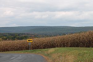
Catawissa Mountain in Roaring Creek Township
|
|

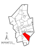
Map of Columbia County, Pennsylvania highlighting Roaring Creek Township
|
|

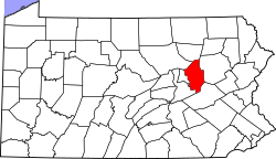
Map of Columbia County, Pennsylvania
|
|
| Country | United States |
| State | Pennsylvania |
| County | Columbia |
| Settled | 1774 |
| Incorporated | 1832 |
| Area | |
| • Total | 23.54 sq mi (60.97 km2) |
| • Land | 23.46 sq mi (60.76 km2) |
| • Water | 0.08 sq mi (0.21 km2) |
| Population
(2010)
|
|
| • Total | 545 |
| • Estimate
(2016)
|
537 |
| • Density | 22.89/sq mi (8.84/km2) |
| Time zone | UTC-5 (Eastern (EST)) |
| • Summer (DST) | UTC-4 (EDT) |
| Area code(s) | 570 |
| FIPS code | 42-037-65240 |
Roaring Creek Township is a small area called a township in Columbia County, Pennsylvania. It's located in Northeastern Pennsylvania. In 2010, about 545 people lived there.
The main office for the township is found at 666 Bear Gap Road in Elysburg, Pennsylvania. This office is actually just outside the township's borders.
Geography of Roaring Creek Township
Roaring Creek Township is in the southern part of Columbia County. To its southeast, it shares a border with Schuylkill County. A wide mountain ridge called Catawissa Mountain runs along the northeast side of the township. This ridge then turns west and becomes Little Mountain, crossing the southern end of the township.
The western and central areas of the township are part of the eastern end of the Roaring Creek valley. Roaring Creek flows northwest towards the Susquehanna River. A small community called Mill Grove is located along the southwest edge of the township, right next to Roaring Creek.
According to the U.S. Census Bureau, the township covers a total area of about 61.0 square kilometers (23.5 square miles). Most of this area, about 60.8 square kilometers (23.5 square miles), is land. Only a small part, about 0.2 square kilometers (0.08 square miles), is water.
People of Roaring Creek Township
| Historical population | |||
|---|---|---|---|
| Census | Pop. | %± | |
| 2010 | 545 | — | |
| 2016 (est.) | 537 | −1.5% | |
| U.S. Decennial Census | |||
In the year 2000, there were 495 people living in Roaring Creek Township. These people made up 198 households, and 149 of those were families.
The township had about 21 people living per square mile (8 people per square kilometer). There were 279 housing units, with about 12 units per square mile (5 units per square kilometer).
Most of the people in the township were White (99.39%). A small number were Asian (0.40%), and 0.20% were from two or more races.
Out of the 198 households, about 29.3% had children under 18 living with them. Most households (66.7%) were married couples living together. About 5.6% had a female head of household with no husband present. Around 24.7% were not families. Also, 22.7% of all households were made up of single individuals. About 14.1% of these individuals were 65 years old or older and living alone.
On average, each household had 2.50 people, and each family had 2.92 people.
The population in the township was spread out by age:
- 21.0% were under 18 years old.
- 6.5% were between 18 and 24 years old.
- 25.1% were between 25 and 44 years old.
- 29.7% were between 45 and 64 years old.
- 17.8% were 65 years old or older.
The average age of people in the township was 43 years. For every 100 females, there were about 98 males. For every 100 females aged 18 and over, there were about 98.5 males.
The average income for a household in the township was $40,625. For families, the average income was $43,125. Males earned an average of $35,795, while females earned an average of $22,250. The average income per person in the township was $21,725.
About 8.7% of families and 9.7% of the total population lived below the poverty line. This included 20.4% of those under 18 years old. No one aged 65 or older was found to be below the poverty line.
See also
 In Spanish: Municipio de Roaring Creek (Pensilvania) para niños


