Rob Roy Glacier facts for kids
Quick facts for kids Rob Roy Glacier |
|
|---|---|

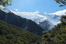
Rob Roy Glacier from below in the Rob Roy Valley
|
|
| Type | Hanging |
| Location | Mount Aspiring National Park |
| Coordinates | 44°28′0″S 168°43′0″E / 44.46667°S 168.71667°E |
| Highest elevation | 2,644 metres (8,675 ft) |
| Lowest elevation | 1,500 metres (4,900 ft) |
The Rob Roy Glacier is a small hanging glacier found in the Southern Alps of New Zealand's South Island. It is part of the beautiful Mount Aspiring National Park. The glacier is about 9 kilometres (6 mi) south of Mount Aspiring / Tititea, a very tall mountain.
A hanging glacier is a glacier that hangs from a steep cliff. The Rob Roy Glacier covers the high, steep sides of the mountains at the top of the Rob Roy Valley. The biggest part of the glacier is on the northwest side of the valley. It sits below Rob Roy Peak, which is 2,644 metres (8,675 ft) tall. This part of the glacier reaches down to a flat area high on the valley side. From there, it suddenly drops over a cliff at about 1,500 metres (4,900 ft) high.
The glacier covers most of the high walls around the valley. However, it doesn't cover the eastern side, where the peaks are a bit lower. When spring comes and the ice melts, small avalanches happen often. Big chunks of ice, called seracs, can also break off the glacier's edge. Sometimes, these large ice blocks tumble all the way down to the valley floor.
How Rob Roy Glacier Formed
In the very distant past, the Rob Roy Glacier was much bigger. It filled the entire Rob Roy Valley. About 20,000 years ago, during the last ice age, it even joined with the huge Matukituki Glacier. The Matukituki Glacier then combined with the Wanaka Glacier. Together, they formed a long river of ice that stretched all the way down the Clutha Valley. Today, the Rob Roy Glacier is much smaller. It is now a hanging glacier at the very top of the valley.
The Rob Roy Valley, which leads into the Matukituki Valley, is now covered with thick, green beech forests. The ground beneath the trees is full of ferns and mosses. Small birds like fantails, tomtits, and riflemans live in the forest. Above the trees, you can often hear and see keas, which are clever mountain parrots.
Rob Roy Peak was named after a Scottish hero called Rob Roy MacGregor. This name was given by the first Europeans who explored the area. They started farming in the Matukituki Valley in the 1870s.
Visiting Rob Roy Glacier
People have been visiting Rob Roy Glacier for over 100 years. Since the 1920s, four generations of the Aspinall family have allowed visitors to cross their land, Mt Aspiring Station, to reach Mount Aspiring National Park.
The Rob Roy Valley Track
The Rob Roy Valley Track is a very popular walk. It usually takes 3 to 4 hours to walk there and back. The path leads to a high mountain basin at the top of the valley. From there, you can see an amazing view of the Rob Roy Glacier across the valley. This glacier is one of the easiest to reach in the area. About 20,000 people visit Rob Roy Glacier every year.
The walking track starts at the Raspberry Creek car park. To get there, you drive along the Wanaka Mount Aspiring Road. The last 30 kilometres (19 mi) of this road is unsealed, meaning it's gravel. The very last 10 kilometres is a "fine weather only" road. It crosses seven shallow rivers, called fords, so it's best to check the weather before you go.
The track begins on farmland. Then, you cross the Matukituki River on a swing bridge. After that, the path follows Rob Roy Stream. It climbs about 330 metres (1,080 ft) up into the Rob Roy Valley. The walk ends at a lookout point just above the tree line. From here, you can look over the valley to the Rob Roy Glacier. It dramatically breaks over a rock ledge high up on the other side of the valley.
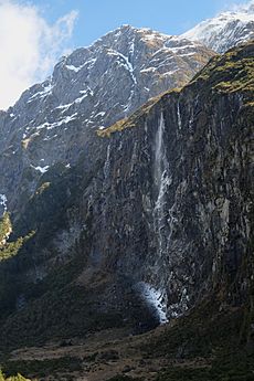
In spring, it's common to see avalanches and ice blocks breaking off the glacier. You can also often hear and see kea birds flying above. You can also clearly see the 261 metres (856 ft) tall Rob Roy Falls. These waterfalls drop freely down a steep cliff face south of the glacier. On cold, sunny days, the melting water from the glacier can refreeze as it falls. This happens when the water passes through the cold air in the shade of the cliff. The water then turns back into ice and snow at the bottom of the waterfall.
You can walk the track by yourself, or you can join a guided tour from Wanaka. There is also a shuttle service for hikers. The Raspberry Creek shelter is also the starting point for longer hiking trails into Mount Aspiring National Park.
In 2015, a wingsuit flier named David Walden did something amazing. He jumped from a cliff at the top of Rob Roy Low Peak, which is 2,560 metres (8,400 ft) high. He was the first person to fly over Rob Roy Glacier and into the valley below using BASE jumping.
 | Frances Mary Albrier |
 | Whitney Young |
 | Muhammad Ali |


