Rock moated site and medieval village facts for kids
Quick facts for kids Rock moated site and medieval village |
|
|---|---|

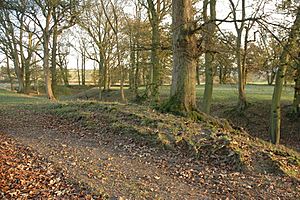
Part of the moat, viewed from the north-west
|
|
| Location | Worcestershire |
| OS grid reference | SO 733 711 |
| Designated | 21 July 1992 |
| Reference no. | 108658 |
| Lua error in Module:Location_map at line 420: attempt to index field 'wikibase' (a nil value). | |
The Rock moated site and medieval village is an interesting old place in Worcestershire, England. It's an archaeological site, which means it's where people study human history through digging up old things. This site includes a deserted medieval village, which is a village that people left a long time ago.
It's located near the modern village of Rock. It's also about 4 miles (6.4 km) southwest of Bewdley. This special site is protected as a Scheduled Monument. This means it's an important historical place that the government wants to keep safe.
What is a Moated Site?
A moated site is a place where a ditch filled with water, called a moat, was built around a building. People usually built moats around their homes or religious buildings. They were often a way to show off wealth or importance, not just for defense.
At Rock, we don't know exactly why the moat was built. Some people thought it might have been a place to keep cattle safe.
History of Rock Village
In the Middle Ages, the village of Rock was much bigger than it is today. In 1328, a man named Henry de Ribbesford owned the area. He was given permission to hold a weekly market there. He could also hold a yearly fair. This fair happened around the feast of St Margaret.
The Church of St Peter and St Paul in Rock is very old. It was first built in the 12th century. More parts were added in the 14th century. Then, it was repaired and updated in the late 1800s.
Exploring the Earthworks
The moated area is right next to the church. It's quite large, measuring about 114 meters (374 ft) from north to south. It's also about 110 meters (360 ft) from west to east. The ditch itself is about 3 meters (10 ft) deep. There's also a raised bank on the outside edge of the ditch.
On the west side, there's an original entrance. It's about 7 meters (23 ft) wide. The area inside the moat is about 0.3 hectares (0.74 acres). The ground inside is uneven, which suggests there are old buildings or features buried there.
Next to the moated site, to the northeast, is where the medieval village used to be. Farmers have ploughed this land in more recent times. But you can still see signs of old streets. These streets ran from northwest to southeast. You can also see where the villagers' homes used to be.

