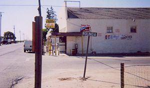
Rolinda, California facts for kids
Quick facts for kids
Rolinda
|
|
|---|---|

Rolinda Store (a.k.a. Rolinda Liquor), a community landmark
|
|
| Country | United States |
| State | California |
| County | Fresno County |
| Elevation | 253 ft (77 m) |
Rolinda is a small farming community in Fresno County, California. It is not an official city or town. It is located about 10 miles (16 km) west of downtown Fresno.
Discovering Rolinda
Rolinda is a quiet place known for its farms. It sits at an elevation of 253 feet (77 meters) above sea level. You can find it along State Route 180.
Location and Services
Rolinda is part of the 559 area code. It does not have its own ZIP code. Mail for Rolinda uses the Fresno ZIP code of 93706. This is common for smaller communities.
Farming and Wildlife
The land around Rolinda is mostly used for farming. Farmers grow Thompson Seedless grapes, which are often used to make raisins. They also grow crops like alfalfa, which is used to feed animals.
You might see many interesting birds in the fields. Cattle egrets often walk around, looking for insects. Birds of prey, like red-shouldered hawks, are also common during the day. They help keep the insect and rodent populations in check.
Schools and History
A well-known place south of Rolinda is the Houghton-Kearney Elementary School. It is part of the Central Unified School District. Before this school, there was the Houghton School, which closed in 1953.
Rolinda also had a post office a long time ago. It was open from 1895 to 1902.
 | Emma Amos |
 | Edward Mitchell Bannister |
 | Larry D. Alexander |
 | Ernie Barnes |


