
Rollins Dam facts for kids
Quick facts for kids Rollins Dam |
|
|---|---|

Rollins Dam Eastern Side walk way
|
|
| Country | The United States of America |
| Location | Nevada County, California |
| Coordinates | 39.136189,-120.952182 |
| Purpose | Water Storage, Flood Control, Recreation, Hydroelectricity |
| Status | Operational |
| Construction began | July 1963 |
| Opening date | December 1965 |
| Owner(s) | Nevada Irrigation District |
| Dam and spillways | |
| Type of dam | Rock fill–earth core dam |
| Impounds | Bear River |
| Length | 500 feet |
| Elevation at crest | 2171 feet |
| Dam volume | 2450000 cubic yards |
| Spillways | 1 |
| Spillway type | Ogee weir an concrete channel |
| Spillway capacity | 60000 second feet |
The Rollins Dam (National ID # CA00255) is a large dam in northern California. It sits on the border of Nevada and Placer counties.
This dam was built in 1965 by the Nevada Irrigation District. It is made of earth and rock, standing about 228 feet tall. The dam holds back the Bear River, which flows into the Feather River.
Rollins Dam helps with many things. It creates electricity, controls floods, stores water for farms, and provides drinking water. It is one of ten facilities owned by the Nevada Irrigation District. The dam is also part of a bigger system called the Yuba-Bear Hydroelectric Project.
The lake behind the dam is called Rollins Reservoir. It covers about 1.3 square miles when full. People enjoy fishing here, especially for trout in spring and bass in summer.
The California Office of Environmental Health Hazard Assessment suggests safe eating guidelines for fish from Rollins Reservoir. This is because small amounts of mercury have been found in some fish.
Contents
Building the Dam

Rollins Dam was built by the Nevada Irrigation District in the 1960s. It was part of the Yuba-Bear Hydroelectric Project. This big project aimed to help Nevada County with flood control, water storage, electricity, and fun outdoor activities.
Construction on the dam started in July 1963 and finished in December 1965. Before building began, an old railroad bridge was taken down. This bridge was once used to carry valuable metals.
A man named Ernest "Ernie" Bierwagen was a director for the NID. He helped oversee the building of Rollins Dam. Ernie's father also helped start the NID many years before. Ernie worked for the district for 25 years.
There is a special plaque dedicated to Ernie Bierwagen at the Orchard Springs Campground. It talks about his dedication to the community and his understanding of how important water is for everyone.
History of the Area
Spanish explorers first came to this area in 1822. They named the river "Rio de Oso," which means Bear River. In 1866, there was a fish hatchery near where Rollins Lake is today.
When the water level in Rollins Lake drops, you can sometimes see old roads and mine tunnels. These are from the Gold Rush days. One mine tunnel, called the Numitor, was started in 1884.
Rollins Dam is named after Dr. Jarret Laben Rollins. He was a doctor and a leader who saw how hard farmers struggled without enough water. Because of this, Nevada and Placer counties worked together. In 1921, they created the Nevada Irrigation District.
Dr. Rollins helped start the Bear River Water and Power Company. Later, this company joined with the NID. In 1962, people approved a plan to build the Yuba-Bear project. Dr. Rollins passed away in 1933, but the Rollins Reservoir was named in his honor in 1966.
Fun Activities
Rollins Reservoir is a great place for outdoor fun!
Fishing
You can catch many types of fish in the lake. These include German Brown Trout, Rainbow Trout, Kokanee, and different kinds of Bass and Catfish.
The Office of Environmental Health Hazard Assessment (OEHHA) has advice for eating fish from the lake. This is because of small amounts of mercury found in some fish. For kids and females, it's suggested to eat only one meal of Bass per month. For adult males, two meals of Bass are okay. For Channel Catfish, kids and females can have two meals a month, and adult males can have four.
</tbody>
| If your body weight is.. | Your meal size should not exceed ... | ||
|---|---|---|---|
| Pounds | kilograms | Ounces | grams |
| 19 | 9 | 1 | 28 |
| 39 | 18 | 2 | 57 |
| 58 | 26 | 3 | 85 |
| 77 | 35 | 4 | 113 |
| 96 | 44 | 5 | 142 |
| 116 | 53 | 6 | 170 |
| 135 | 61 | 7 | 199 |
| 154 | 70 | 8 | 227 |
| 173 | 79 | 9 | 255 |
| 193 | 88 | 10 | 284 |
| 212 | 96 | 11 | 312 |
| ≥231 | ≥105 | 12 | 340 |
Camping
There are several campgrounds around Rollins Reservoir. These include Greenhorn, Long Ravine, Orchard Springs, and Peninsula Camping. The NID owns and runs these campgrounds.
Together, they offer about 250 campsites with many services. You can find showers, picnic areas, volleyball courts, and places for campfires. Some campgrounds even have a general store and an arcade!
Fun events for kids, like an Easter Egg Hunt and a kids' Triathlon, happen here every year. Pets are welcome for a small daily fee. Hunting and metal detecting are not allowed. The campground gates close at 10:00 p.m. and open at 6:00 a.m. They are open all year.
Boating
You can rent different kinds of boats at Rollins Lake. These include ski boats, wakeboard boats, pontoon boats, and fishing boats. Kayaks, paddleboards, and canoes are also available. Rentals are for 3 or 7 hours, from 10 a.m. to 6 p.m. You can also bring your own boat, as long as it follows California boating rules.
How the River Flows
Rollins Dam is built on the Bear River. This river starts high in the Sierra Nevada mountains. Water for the river also comes from Spaulding Lake.
The water flows through different areas like Drum Afterbay and Dutch Flat Reservoir. Before it reaches Rollins Reservoir, it joins with Steephollow Creek. After Rollins Reservoir, the water continues to Lake Combie and other places. Eventually, it flows into the Feather River and then into the Sacramento River.
Making Electricity
After the Gold Rush, many old mining sites were used to produce water and power. The NID started making hydroelectric power in 1966. This was when the Yuba–Bear Power Project was completed.
The Rollins power plant alone can generate about 12.15 megawatts of electricity. All the NID power plants together make enough energy for many homes. The NID then sells this energy to Pacific Gas & Electric Company (PG&E).
Dam Maintenance

Like any big structure, Rollins Dam needs regular check-ups and maintenance.
Valve Check
In 2017, after another dam had issues, many dams in California were checked. Reports showed that a valve at Rollins Dam was not opening fully in 2014 and 2015. The NID approved replacing this valve in 2017 to make sure everything worked perfectly.
Sediment Build-up
Over the years, dirt and gravel have built up in Rollins Reservoir. This "sediment" takes up space that could be used to store water. The NID is working on a project called the Bear Sediment Removal Project. This project aims to clean out the sediment and keep the reservoir working well. They plan to remove gravel from the Bear River and Steephollow Creek to help with this.
Images for kids
-
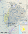
Map of the Feather River watershed; Rollins Reservoir is southeast of the town of Grass Valley.

