Romeo Island facts for kids

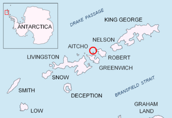
Location of Aitcho Islands in the South Shetland Islands.
|
|
|
Location of Barrientos Island
|
|
| Geography | |
|---|---|
| Location | Antarctica |
| Coordinates | 62°22′34.7″S 59°55′30.6″W / 62.376306°S 59.925167°W |
| Archipelago | South Shetland Islands |
| Area | 44 ha (110 acres) |
| Length | 1.35 km (0.839 mi) |
| Width | 0.47 km (0.292 mi) |
| Administration | |
| Administered under the Antarctic Treaty System | |
| Demographics | |
| Population | uninhabited |
Romeo Island is a small, rocky island located in a very cold place called Antarctica. It is part of a group of islands known as the South Shetland Islands. This island is found just off the north coast of Greenwich Island and west of the Aitcho Islands.
The island stretches about 1.35 kilometers (0.84 miles) in a west-northwest direction. It is about 470 meters (0.29 miles) wide. The total surface area of Romeo Island is 44 hectares (about 109 acres). No one lives on Romeo Island today.
Contents
History of Romeo Island
The area around Romeo Island was visited by sealers in the early 1800s. These were people who hunted seals for their fur and oil.
How Romeo Island Got Its Name
Romeo Island is named after a British sealing ship called Romeo. This ship was led by Captain James Johnson. The Romeo visited the South Shetland Islands in 1821 and 1822. It even stayed in Clothier Harbour in March 1822.
Where is Romeo Island Located?
The center of Romeo Island is located at coordinates 62°22′34.7″S, 59°55′30.6″W. It is situated in a specific part of the South Shetland Islands.
Nearby Islands
Romeo Island is about 9.45 kilometers (5.87 miles) northeast of Duff Point on Greenwich Island. It is also around 6.7 kilometers (4.2 miles) southwest of Table Island. Other nearby islands include Stoker Island, which is 4.05 kilometers (2.52 miles) northwest, and Ongley Island, which is 5.3 kilometers (3.3 miles) north by west.
Mapping and Surveys
Different countries have mapped and surveyed this area over the years. British maps were made in 1962 and 1968. Chilean maps were created in 1971, and Argentine maps in 1980. More recently, Bulgarian maps were made in 2005 and 2009. These maps help us understand the exact location and size of Romeo Island.
 | Emma Amos |
 | Edward Mitchell Bannister |
 | Larry D. Alexander |
 | Ernie Barnes |


