Table Island (South Shetland Islands) facts for kids

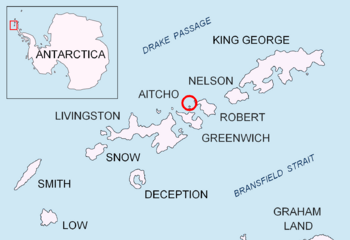
Location of Aitcho Islands in the South Shetland Islands
|
|
|
Location of Table Island
|
|
| Geography | |
|---|---|
| Location | Antarctica |
| Coordinates | 62°20′34.8″S 59°48′29.7″W / 62.343000°S 59.808250°W |
| Archipelago | South Shetland Islands |
| Area | 1.12 km2 (0.43 sq mi) |
| Length | 1.4 km (0.87 mi) |
| Width | 1.0 km (0.62 mi) |
| Highest elevation | 150 m (490 ft) |
| Administration | |
| Administered under the Antarctic Treaty System | |
| Demographics | |
| Population | uninhabited |
Table Island is a cool, flat-topped rocky island in Antarctica. It is part of the South Shetland Islands. This island is quite tall, rising over 150 meters (about 492 feet) from the sea. It is also pretty big, stretching about 1.4 kilometers (0.87 miles) long and 1.0 kilometer (0.62 miles) wide. Table Island is located north of Greenwich Island and near the Aitcho Islands. It sits on the west side of English Strait. No people live on Table Island.
Nearby, there is a rock called Turmoil Rock. It is about 1.32 kilometers (0.82 miles) southeast of Table Island. This area was visited by sealers a long time ago, in the early 1800s. Sealers were people who hunted seals.
How Table Island Got Its Name
Table Island got its name because of its shape. It looks like a flat table. The sealers who saw it thought the name fit perfectly.
Turmoil Rock also got its name from how it looks. It creates big waves, called breakers, around it. This makes the water look like it is in "turmoil."
These names were officially given after a survey. This survey was done by a ship called HMS Protector in 1967.
Where is Table Island?
The center of Table Island is located at 62°20′34.8″S 59°48′29.7″W / 62.343000°S 59.808250°W. It is in a busy area of islands.
Here are some distances to other nearby places:
- About 4.85 kilometers (3.01 miles) northwest of Fort William on Robert Island.
- About 7.9 kilometers (4.9 miles) north of Dee Island.
- About 2.5 kilometers (1.6 miles) north of Morris Rock.
- About 4.14 kilometers (2.57 miles) north by east of Holmes Rock.
- About 6.1 kilometers (3.8 miles) northeast of Romeo Island.
- About 2.76 kilometers (1.71 miles) southwest of Potmess Rocks.
- About 4.68 kilometers (2.91 miles) west by south of Rogozen Island.
Many countries have mapped this area over the years. These include British maps from 1820, 1821, 1822, 1935, and 1968. Spain mapped it in 1861, Chile in 1947, Argentina in 1980, and Bulgaria in 2005 and 2009.
 | Leon Lynch |
 | Milton P. Webster |
 | Ferdinand Smith |


